Unmanned aerial vehicle position estimation system and estimation method based on visual sensor

A visual sensor and unmanned aerial vehicle technology, applied in the direction of control/regulation system, three-dimensional position/course control, vehicle position/route/altitude control, etc., can solve problems such as limited bandwidth, high price, limited use range, etc., to avoid Transmission delay, high resource utilization, and the effect of real-time estimation

Active Publication Date: 2021-07-13
南京云智控产业技术研究院有限公司
View PDF4 Cites 2 Cited by
  • Summary
  • Abstract
  • Description
  • Claims
  • Application Information

AI Technical Summary

Problems solved by technology

In the process of offline transmission, due to the limited bandwidth of wireless transmission technology, it often leads to a long time data delay, which affects the real-time performance of positioning
Chinese invention patent CN201610634278.3 discloses a UAV positioning system, which uses an airborne camera to transmit image data to the ground station for analysis and calculation. This method is difficult to achieve ideal real-time estimation when the image is relatively complex.
[0005] The above positioning schemes are often limited by sensor performance and computer computing power.
In order to eliminate the impact of offline transmission on positioning, expensive micro-computing equipment is often used, which is expensive and has a very limited range of use.

Method used


Image

  • Unmanned aerial vehicle position estimation system and estimation method based on visual sensor
  • Unmanned aerial vehicle position estimation system and estimation method based on visual sensor
  • Unmanned aerial vehicle position estimation system and estimation method based on visual sensor

Examples


Embodiment Construction

[0046] The present invention will be further explained below in conjunction with the accompanying drawings and specific embodiments. It should be understood that the following specific embodiments are only used to illustrate the present invention and are not intended to limit the scope of the present invention.

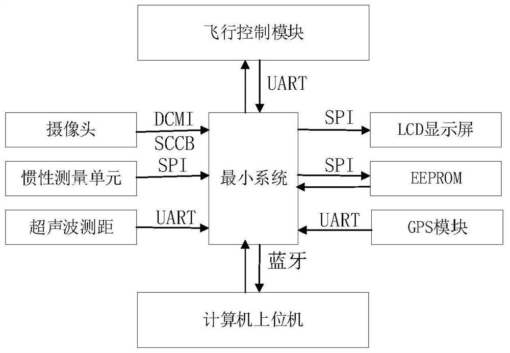
[0047] Such as figure 1 As shown, a visual sensor-based UAV position estimation system of the present invention includes an MCU module and a flight control module mounted on the UAV; the MCU module is respectively connected to a camera, an inertial measurement unit, an ultrasonic ranging sensor, GPS sensor, LCD display screen, EEPROM; the MCU module realizes data transmission between the flight control module and the universal asynchronous transceiver transmitter; the MCU module communicates with the upper computer of the computer through bluetooth Data transmission is realized; the installation angle of the inertial measurement unit is parallel to the body of the UAV...


PUM


Abstract

The invention discloses an unmanned aerial vehicle position estimation system and method based on a visual sensor. The system comprises an MCU module carried on an unmanned aerial vehicle and a flight control module. The MCU module is respectively connected with the camera, the inertial measurement unit, the ultrasonic ranging sensor, the GPS sensor, the LCD display screen and the electrified erasable programmable read-only memory; data transmission is realized between the MCU module and the flight control module through a universal asynchronous transceiving transmitter; data transmission is realized between the MCU module and the upper computer through Bluetooth; the mounting angle of the inertial measurement unit is parallel to the body of the unmanned aerial vehicle, and the mounting angles of the camera and the laser distance measuring sensor are perpendicular to the body of the unmanned aerial vehicle. According to the invention, under the condition that the manufacturing cost is not increased, the measurement precision and the calculation rate of pose estimation are both considered.

Description

technical field [0001] The invention belongs to the technical field of control engineering, in particular to realize high-precision pose estimation of a small quadrotor UAV, and in particular to a UAV position estimation system and estimation method based on a visual sensor. Background technique [0002] UAV has the characteristics of compact structure, low price, small size, and light weight. It has broad military and civilian prospects and is a hot topic in the development of global science and technology. With the development of UAV control technology, the autonomous positioning of UAV has become one of the key technologies of UAV. In order to realize the autonomous flight of UAVs and improve the ability of UAVs to complete tasks, autonomous positioning has far-reaching significance for the development of UAVs. How to achieve high-precision autonomous positioning has become a hot topic in UAV research. [0003] The Global Positioning System (GPS) is a satellite-based gl...

Claims


Application Information

Patent Timeline
Patent Type & Authority Applications(China)
IPC IPC(8): G05D1/08G05D1/10
CPCG05D1/0808G05D1/101
Inventor 解乃颖余瑶孙佳刘剑薛磊
Owner 南京云智控产业技术研究院有限公司
Why Eureka
Try Eureka