Visual and instrument flight program automatic aided design system

A flight program and auxiliary design technology, applied in design optimization/simulation, special data processing applications, geometric CAD, etc., can solve problems such as insufficient human-computer interaction, low practicability, and inconsistent standards

Pending Publication Date: 2021-07-30
CIVIL AVIATION UNIV OF CHINA
View PDF2 Cites 1 Cited by
  • Summary
  • Abstract
  • Description
  • Claims
  • Application Information

AI Technical Summary

Problems solved by technology

Advantages of domestic existing technology: The advantages of GIS-based flight program design are that the design process is simple, easy to template, easy to understand, easy to add new functions and design new algorithms; disadvantages: incomplete functions, insufficient human-computer interaction, And it does not provide the functions of unit labeling and auxiliary information labeling
Disadvantages of existing foreign technologies: 1) The standards followed by domestic and foreign flight program design are not completely consistent, and the design results given by foreign systems do not apply to domestic standards; 2) Domestic front-line flight program designers generally use CAD platforms for daily design tools, and the design results of the GIS platform cannot be directly imported into the CAD platform for secondary modification to adapt to domestic standards
Therefore, the practicability of foreign systems in China is not high
[0004] To sum up, there are currently no relatively mature programs based on the actual operating conditions in our country, which can guarantee the safety of airport flight and air traffic control operations, and meet the daily habits of domestic front-line flight program designers. Based on a small number of navigation parameters Visual and instrument flight procedure automation aided design method and system

Method used


Image

  • Visual and instrument flight program automatic aided design system
  • Visual and instrument flight program automatic aided design system
  • Visual and instrument flight program automatic aided design system

Examples


Embodiment approach

[0042] Step 1: The user inputs the latitude and longitude grid parameters: coordinate system type (WG84 / Beijing 54 / Xi'an 80 / CGCS2000), the latitude and longitude of the center point, the upper and lower limits of the latitude and longitude grid, and the degree interval of latitude and longitude.

[0043] Step 2: The system automatically calculates the longitude and latitude coordinate set P of the point sets at fixed intervals on the central meridian and all longitude and latitude lines.

[0044] Step 3: The system automatically converts the point set latitude and longitude coordinate set P into the geometric coordinate set G on the CAD screen interface.

[0045] Step 4: The system draws the central meridian and all longitude and latitude lines on the screen according to the geometric coordinate set G.

[0046] 2. Implementation of the geographic coordinate system query and export sub-module:

[0047] Step 1: The user clicks the coordinate system export button;

[0048] Step...


PUM


Abstract

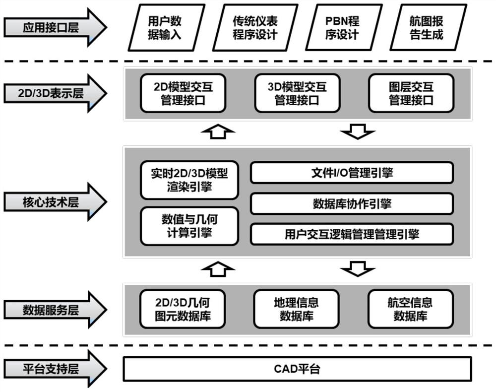
The invention discloses avisual and instrumentation flight program automatic aided design system. The automatic aided design system comprises an application interface layer, a system middle layer and a platform support layer; the application interface layer comprises a user input data parameter interface, a traditional instrument program design interface and the like; the system middle layer comprises a 2D / 3D presentation layer, a core technology layer and a data service layer; the 2D / 3D presentation layer comprises a 2D / 3D graphic interaction interface, a dialog box management interface and the like; the data service layer comprises a 2D / 3D geometric primitive database, a map information database and a chart information database; the platform support layer mainly uses a CAD platform and other bottom layer support technologies. The invention belongs to the field of computer aided design, and particularly relates to a visual and instrument flight program automatic aided design system which can guarantee airport flight and air traffic control operation safety and meet daily use habits of domestic first-line flight program designers.

Description

technical field [0001] The invention belongs to the field of computer-aided design, and specifically refers to a visual and instrument flight program automation aided design system. Background technique [0002] At present, domestic flight procedure aided design systems include: flight procedure design based on GIS, flight procedure computer aided design system (FPCAD for short) of Civil Aviation North China Air Traffic Management Bureau, and auxiliary flight procedure design system based on MAPINFO or SUPERMAP as the development platform. In 1996, the North China Bureau developed FPCAD, namely "Non-Precision Approach Computer Aided System", and there is no mature product yet. The assisted flight procedure design system based on MAPINFO or SUPERMAP as the development platform is an early product of GIS. The domestically developed flight procedure assisted design methods and systems are all based on scanned maps, and there is a problem of map splicing. Moreover, these aided ...

Claims


Application Information

Patent Timeline
Patent Type & Authority Applications(China)
IPC IPC(8): G06F30/12G06F30/20
CPCG06F30/12G06F30/20
Inventor 苏乐翟文鹏
Owner CIVIL AVIATION UNIV OF CHINA
Why Eureka
Try Eureka