Space-based optical angle measurement segmental arc initial orbit determination and association method for GEO target

An arc segment and target technology, applied in the aerospace field, to achieve the effect of improving the success rate of association, improving the determination accuracy, and improving the global search ability

Active Publication Date: 2021-08-03
NAT SPACE SCI CENT CAS
View PDF8 Cites 9 Cited by
  • Summary
  • Abstract
  • Description
  • Claims
  • Application Information

AI Technical Summary

Problems solved by technology

[0003] The purpose of the present invention is to overcome the defects of the prior art. In order to solve the problem of determining the initial orbit of the ultra-short arc section of the space-based optical angle measurement for GEO targets and the arc section correlation problem, a method for determining the initial orbit based on the improved bacterial foraging algorithm is proposed and Correlation method of GEO target arcs based on azimuth characteristics (latitude and longitude of sub-satellite points)

Method used


Image

  • Space-based optical angle measurement segmental arc initial orbit determination and association method for GEO target
  • Space-based optical angle measurement segmental arc initial orbit determination and association method for GEO target
  • Space-based optical angle measurement segmental arc initial orbit determination and association method for GEO target

Examples


Embodiment 1

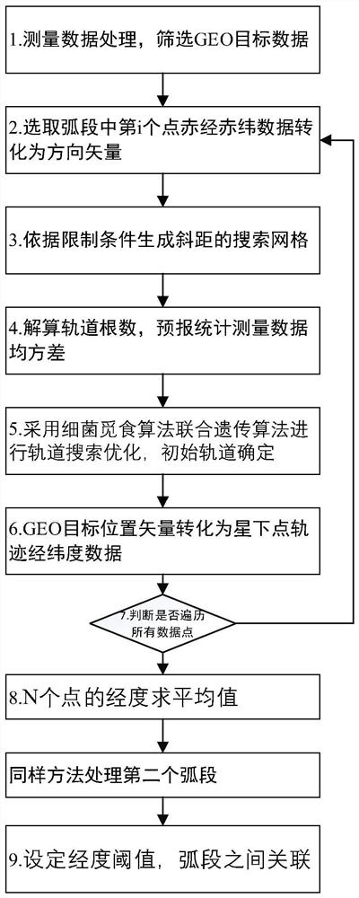
[0064] like figure 1 As shown, Embodiment 1 of the present invention proposes a method for preliminary orbit determination and correlation of space-based optical angle measurement arcs for GEO targets, and its specific steps include:

[0065] Step 1. Space-based platform measurement data processing, coordinate system conversion, and screening of GEO target right ascension and declination data. In this embodiment, step 1 may include the following steps S11-S13, specifically:

[0066] S11: Screen the measurement arc of the space-based platform, if the maximum value of the declination data of the measured value in a certain measurement arc is δ max If it is greater than 15°, the arc segment is discarded.

[0067] S12: Transform the height, latitude and longitude data of the space-based measurement platform in the ground-fixed coordinate system into position and velocity data in the J2000 coordinate system r site_mi and v site_mi .

[0068] Step 2: The right ascension and dec...


PUM


Abstract

The invention discloses a space-based optical angle measurement segmental arc initial orbit determination and association method for a GEO target, and the method comprises the steps: screening a space-based platform measurement segmental arc, and carrying out the coordinate system conversion of the height and latitude and longitude data of a space-based platform, and obtaining a position vector and a velocity vector under a J2000 coordinate system; selecting two space-based platform measurement arc segments aiming at the GEO target from the screened measurement arc segments, and respectively sampling right ascension and declination data in the two arc segments; for each arc section, according to right ascension and declination data of a sampling point, determining a distance range from the space-based platform to the GEO target to generate a slope distance search grid point, in the search grid point, determining an initial orbit corresponding to each sampling point by adopting a bacterial foraging algorithm and a genetic algorithm, and obtaining a corresponding sub-satellite point trajectory; further obtaining a longitude average value of each arc section; and calculating a difference value of the longitude average values of the two arc segments, and when the difference value is smaller than a preset threshold value, determining that the two arc segments are associated.

Description

technical field [0001] The invention belongs to the field of spaceflight technology, and relates to space-based optical angle measurement arc section preliminary orbit determination and a related method for GEO targets. Background technique [0002] The problem faced in the GEO (Geostationary Orbit, geostationary orbit) target space-based optical measurement arc identification project is that the measurement data of hundreds of ultra-short arcs cannot be effectively used every day, resulting in a waste of resources. The full use of these data can directly increase the number of space object catalogs and improve the early warning level of my country's space object catalogs. The main difficulty in orbit determination of space-based optical GEO targets is that the measurement arc is relatively short, generally less than 3 minutes. The shorter the arc, the more ill-conditioned the orbit determination of the traditional Laplace method and Gaussian method, especially the lower th...

Claims


Application Information

Patent Timeline
Patent Type & Authority Applications(China)
IPC IPC(8): G06F30/27G06N3/12
CPCG06N3/126G06F30/27
Inventor 闫瑞东龚建村罗冰显刘四清王荣兰师立勤
Owner NAT SPACE SCI CENT CAS
Why Eureka
Try Eureka