Microtopography icing value prediction method and system
A numerical prediction and micro-topography technology, applied in prediction, CAD numerical modeling, data processing applications, etc., can solve the problems of computational fluid models without considering physical processes and coarse resolution, and achieve good versatility and rationality Effect
- Summary
- Abstract
- Description
- Claims
- Application Information
AI Technical Summary
Problems solved by technology
Method used
Image
Examples
Embodiment 1
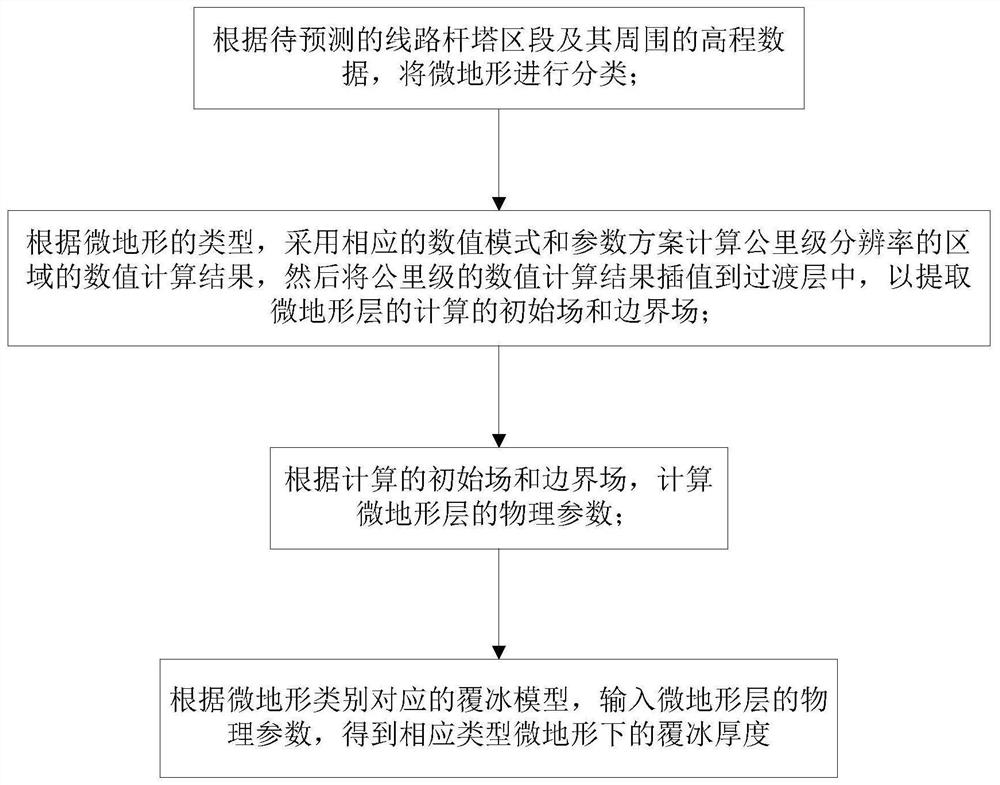
[0043] The micro terrain icing numerical prediction method of the present embodiment comprises the following steps:
[0044] (1) Micro terrain classification:
[0045] Determine the line tower section M that needs to be predicted. According to the high-precision digital elevation data, use ArcGIS to extract the ridge line and valley line within 10km around M as the center, and calculate the directions of the ridge line and valley line closest to M Vectors H and L, and calculate the angle between the direction vector m of M and the two, and record it as θ H and θ L .
[0046]
[0047]
[0048] Sort the digital elevations in the 10km range around M from large to small, and obtain the sorted positions h1 and h2 of the altitudes of the towers on both sides of the M section, and set the threshold θ of the included angle α , θβ , satisfying 0α β α , h β , satisfying 0α β <100%, set the following classification identification table:
[0049] Table 1 Non-water body micro-to...
Embodiment 2
[0081] Taking a 500kV ice-covered micro-topography section as an example, the numerical prediction of micro-topography icing includes the following steps:
[0082] (1) Micro terrain classification:
[0083] Determine the line tower section M that needs to be predicted. According to the high-precision digital elevation data, use ArcGIS to extract the ridge line and valley line within 10km around M as the center, and calculate the directions of the ridge line and valley line closest to M Vectors H and L, and calculate the angle between the direction vector m of M and the two, and record it as θ H = π / 3 and θ L = π / 3.
[0084] Sort the digital elevations in the 10km range around M from large to small, and obtain the sorted positions of 85% and 90% of the altitude of the towers on both sides of the M section, and set the threshold of the included angle θ α = π / 12, θ β =5π / 12, satisfying 0α β α = 20%, h β =80%, satisfy 0α β <100%, meet the micro-topography of the pass accordin...
Embodiment 3
[0101] Taking a 220kV ice-covered micro-topography section as an example, the numerical prediction of micro-topography icing includes the following steps:
[0102] (1) Micro terrain classification:
[0103]Determine the line tower section M that needs to be predicted. According to the high-precision digital elevation data, use ArcGIS to extract the ridge line and valley line within 10km around M as the center, and calculate the directions of the ridge line and valley line closest to M Vectors H and L, and calculate the angle between the direction vector m of M and the two, and record it as θ H = π / 15 and θ L = π / 15.
[0104] Sort the digital elevations in the 10km range around M from large to small, and obtain the sorted positions of 85% and 90% of the altitude of the towers on both sides of the M section, and set the threshold of the included angle θ α = π / 12, θ β =5π / 12, satisfying 0α β α = 20%, h β =80%, satisfy 0α β <100%, meet the micro-topography of the pass accordi...
PUM
 Abstract
Description
Claims
Application Information
 - R&D
- Intellectual Property
- Life Sciences
- Materials
- Tech Scout
- Unparalleled Data Quality
- Higher Quality Content
- 60% Fewer Hallucinations
Browse by: Latest US Patents, China's latest patents, Technical Efficacy Thesaurus, Application Domain, Technology Topic, Popular Technical Reports.
© 2025 PatSnap. All rights reserved.Legal|Privacy policy|Modern Slavery Act Transparency Statement|Sitemap|About US| Contact US: help@patsnap.com


