WRF-Hydro key parameter calibration method for quantitatively estimating rainfall by combining rainfall station with radar

A technology of key parameters and rainfall stations, which is applied in the direction of rainfall/precipitation gauges, measuring devices, weather condition prediction, etc., and can solve the problem that low-density rainfall stations cannot meet the accuracy of spatial modeling

Active Publication Date: 2021-08-20
CHINA INST OF WATER RESOURCES & HYDROPOWER RES
View PDF17 Cites 3 Cited by
  • Summary
  • Abstract
  • Description
  • Claims
  • Application Information

AI Technical Summary

Problems solved by technology

[0005] In order to solve the above-mentioned technical problems, the present invention proposes a WRF-Hydro key parameter calibration method for quantitatively estimating rainfall with rainfall stations fused with radar. The main technical problem it solves is that low-dens

Method used


Image

  • WRF-Hydro key parameter calibration method for quantitatively estimating rainfall by combining rainfall station with radar
  • WRF-Hydro key parameter calibration method for quantitatively estimating rainfall by combining rainfall station with radar
  • WRF-Hydro key parameter calibration method for quantitatively estimating rainfall by combining rainfall station with radar

Examples


Embodiment 1

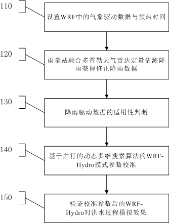
[0088] like figure 1 As shown, step 110 is executed to set weather driving data and warm-up time in the weather forecast mode WRF, the weather driving data includes temperature driving data, pressure driving data, wind speed driving data and rainfall driving data. The WRF adopts a three-layer embedding method, and the innermost region is used to provide the WRF-Hydro with input of at least one mode of rainfall, radiation, humidity, temperature, air pressure, and wind speed. Two warm-up periods are set during the warm-up process of the WRF: the first warm-up period is 16 days before the rain starts, and the Restart file is output on the 15th day, so that the land surface preheating can obtain a relatively accurate model Lower boundary data, and generate Restart at the end of warm-up; the second warm-up period is 24 hours before the rain starts, and the second warm-up period calls the lower boundary data in the Restart file and the side boundary data in the WRF drive data .

...

Embodiment 2

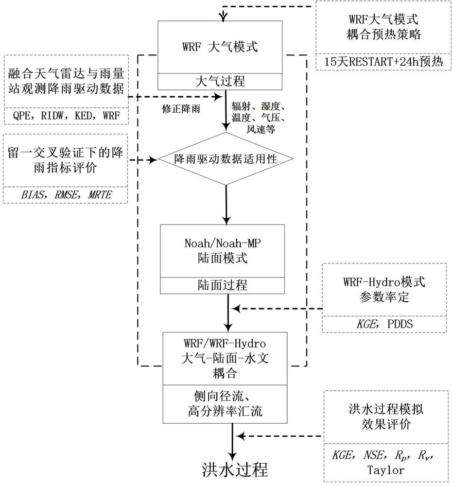
[0138] like figure 2 As shown, the present invention designs a WRF-Hydro key parameter calibration method for quantitatively estimating rainfall by rainfall station fusion radar. The method of quantitatively estimating and merging rainfall with Doppler weather radar improves the temporal and spatial distribution characteristics of rainfall, and uses the parallel dynamic multidimensional search algorithm (P-DDS) to calibrate the WRF / WRF-Hydro land-atmosphere coupling process parameters to improve land surface hydrology. The simulation accuracy of the model for the flood process.

[0139] In order to solve the above-mentioned technical problems, the present invention adopts the following scheme:

[0140] A WRF-Hydro key parameter calibration method for quantitatively estimating rainfall using rainfall station fusion radar, including the following steps:

[0141] Step 1. Set the weather driving data and warm-up time in WRF;

[0142] Step 2. The rainfall station integrates the...

Embodiment 3

[0189] Below in conjunction with implementation examples, the present invention is further described: step 1, the meteorological driving data and the warm-up time in the WRF are set; Step 2, the rainfall station fuses the Doppler weather radar to quantitatively estimate rainfall (QPE) and obtains the corrected rainfall data; step 3. Comparative verification of rainfall-driven data; Step 4. Calibration of WRF-Hydro model parameters based on the parallel dynamic multidimensional search algorithm (P-DDS); Step 5. Verify the simulation effect of WRF-Hydro on the flood process after the calibration parameters.

[0190] Step 1. Set the meteorological driving data and warm-up time in WRF. Here, two mesoscale basins, Fuping (2210km 2 ) and Zijingguan (1760km 2 ), the radar station selected the Shijiazhuang radar station in the watershed (such as image 3 shown), WRF adopts a three-layer embedding method (the nesting ratio of each layer is 1:3, and the resolutions from outside to insi...


PUM


Abstract

The invention provides a WRF-Hydro key parameter calibration method for quantitatively estimating rainfall by fusing a rainfall station with a radar. The method comprises the following steps: setting meteorological driving data and preheating time in WRF; fusing the rainfall station with a Doppler weather radar to quantitatively estimate rainfall to obtain corrected rainfall data; judging the applicability of the rainfall driving data; carrying out WRF-Hydro mode parameter calibration based on a parallel dynamic multi-dimensional search algorithm (P-DDS); and verifying the simulation effect of the WRF-Hydro on the flood process after parameter calibration. The radar and rainfall station fusion rainfall can improve the space-time accuracy of an input mode, can more stably describe rainfall with non-uniform space-time distribution, and can improve the parameter calibration process of the WRF-Hydro by taking the rainfall as rainfall driving data for calibrating the WRF-Hydro land surface hydrological mode and cooperating with a parallel dynamic multi-dimensional search algorithm (P-DDS), so that the accuracy of the radar and rainfall station fusion rainfall is improved, and the simulation precision of the rainfall flood in the session is improved.

Description

technical field [0001] The invention relates to the technical field of hydrometeorology, in particular to a method for calibrating WRF-Hydro key parameters for quantitatively estimating rainfall by rainfall station fusion radar. Background technique [0002] WRF-Hydro is a representative of more complex land surface hydrological models in the world in recent years. It can provide simulation / forecast information of the spatiotemporal elements of hydrological processes through the coupling of WRF and WRF-Hydro. However, it is subject to the influence of input data and calibration method. The usual parameter setting adopts the WRF and WRF-Hydro coupling method, and the input rainfall is not the actual "true value", which will greatly affect the simulation / forecast effect. [0003] As a sensor that directly observes rainfall, rain gauges can observe rainfall at relatively precise locations, but the maintenance and detection costs of rain gauge stations are relatively high. In n...

Claims


Application Information

Patent Timeline
IPC IPC(8): G01S13/95G01S7/41G01W1/14G01W1/10G01W1/02
CPCG01S7/41G01S13/95G01W1/02G01W1/10G01W1/14Y02A10/40Y02A90/10
Inventor 刘佳李传哲王维于福亮顾艳玲
Owner CHINA INST OF WATER RESOURCES & HYDROPOWER RES
Why Eureka
Try Eureka