Three-dimensional reconstruction method of topography of scour area of ​​bridge pier foundation based on scanning sonar imaging

A scanning sonar and three-dimensional reconstruction technology, which is applied in the direction of sound wave re-radiation, measuring instruments, instruments, etc., can solve problems such as device failure, high detection efficiency, and discrete measurement data

Active Publication Date: 2022-08-05
FUZHOU UNIV
View PDF9 Cites 0 Cited by
  • Summary
  • Abstract
  • Description
  • Claims
  • Application Information

AI Technical Summary

Problems solved by technology

[0003] The traditional foundation scour detection device has high installation and maintenance costs, and it is easily affected by debris during floods, causing the device to fail, and the measured data is relatively discrete, and the detection efficiency is low
Compared with traditional detection devices, sonar equipment is easier to install. A single scan of the foundation scour can obtain multiple scour depth data. The detection efficiency is high, and the foundation scour terrain in different directions of the pier can be detected by moving the position of the measuring point. In this way, the lateral contours of the foundation scoured terrain in different azimuths can be obtained, but the collected acoustic images can only reflect the contours of the terrain scoured in a certain area covered by the beam, and it is difficult to completely restore the overall terrain and landform information scoured around the pier foundation

Method used


Image

  • Three-dimensional reconstruction method of topography of scour area of ​​bridge pier foundation based on scanning sonar imaging
  • Three-dimensional reconstruction method of topography of scour area of ​​bridge pier foundation based on scanning sonar imaging
  • Three-dimensional reconstruction method of topography of scour area of ​​bridge pier foundation based on scanning sonar imaging

Examples


Embodiment Construction

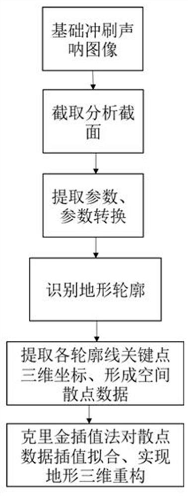
[0030] As shown in the figure, the three-dimensional reconstruction method of the terrain of the scour area of ​​the bridge pier foundation based on the scanning sonar imaging, the method includes the following steps;

[0031] Step S1, using mechanical scanning sonar equipment to perform a complete scan and imaging of the terrain of the pier foundation scour area from different directions, and collect n groups of foundation scour terrain sonograms in different directions;

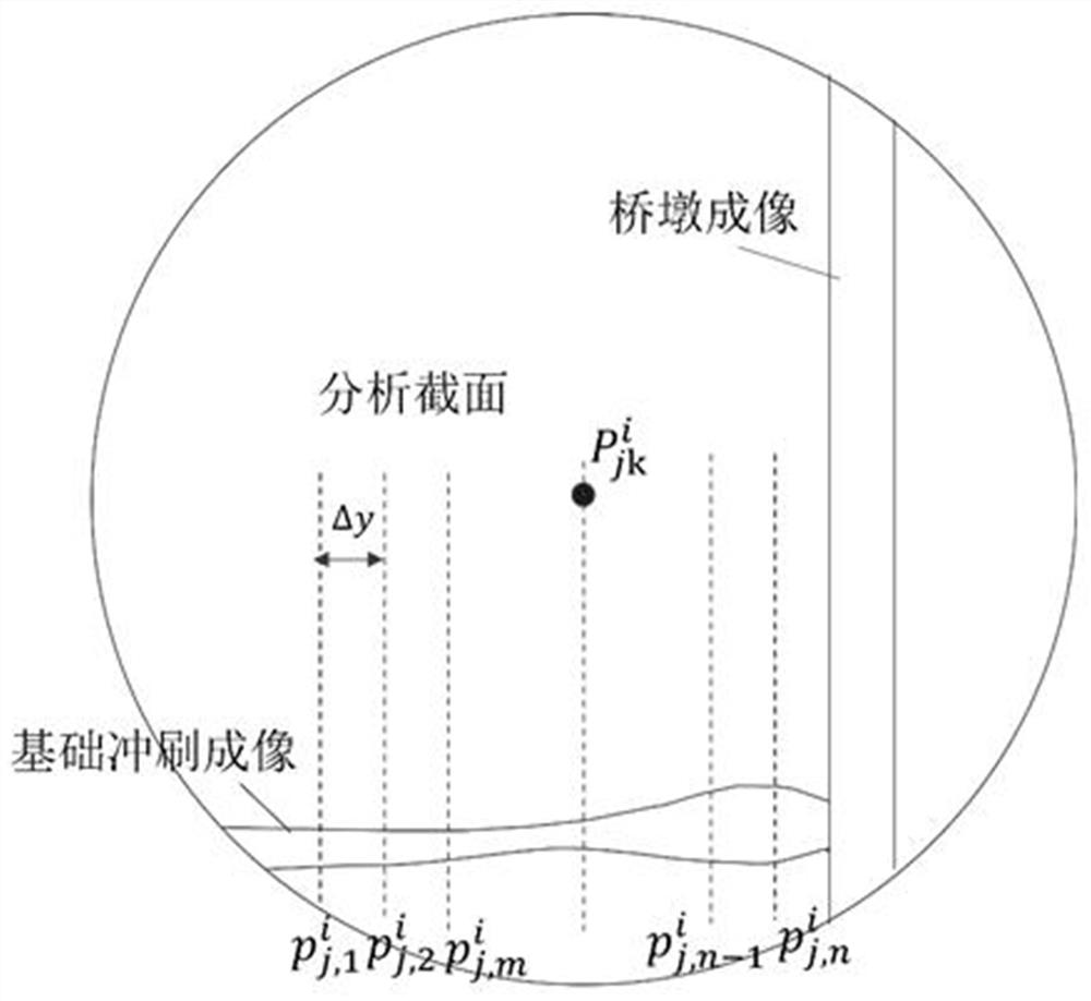
[0032] Step S2, intercepting a plurality of analysis sections with the same spacing for each group of the collected sonograms;

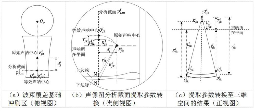
[0033] Step S3, extracting the key parameters of the upper and lower edges of the image strip formed in the analysis section in the figure, converting the extracted parameters into a three-dimensional space according to the principle of acoustic imaging, and expressing the sonar beam fan surface by a fan arc;

[0034] Step S4, according to the relative positional relationship of t...


PUM


Abstract

The present invention proposes a three-dimensional reconstruction method for the terrain of the scour area of ​​the bridge pier foundation based on scanning sonar imaging, which includes the following steps: Step S1, use sonar to completely scan and image the terrain of the pier foundation scour area from different directions, and collect n Assemble the basic scour topographic sonogram; Step S2, intercept a plurality of analysis sections at the same distance from the collected sonogram; Step S3, extract the key parameters of the upper and lower edges of the image strips formed in the analysis section in the figure, and convert them into three-dimensional space , and express the sonar beam fan surface by fan arc; Step S4, identify the contour shape of the scour topography according to the relative positional relationship of a group of measuring points in the same analysis section; Step S5, identify each topographic contour shape one by one, and extract them respectively The three-dimensional coordinate data of the spatial scattered points is obtained; in step S6, kriging interpolation method is used to interpolate and fit the spatial scattered data to complete the three-dimensional reconstruction of the foundation scour terrain; the present invention can realize the three-dimensional restoration of the terrain of the pier foundation scour area. Purpose.

Description

technical field [0001] The invention relates to the technical field of scour terrain detection for underwater bridge pier foundations, in particular to a three-dimensional reconstruction method for the scour area of ​​bridge pier foundations based on scanning sonar imaging. Background technique [0002] The pier foundation has been in a complex water environment for a long time. Under the action of scouring, the river bed is continuously cut down, and the buried depth of the foundation is reduced, resulting in foundation scouring disease. During the flood period, the scouring effect is more intense, and the old bridges are subject to long-term local scouring, and there are major safety hazards, and they are prone to overturning under severe flood scouring. Therefore, regular inspection of pier foundation scour and mastering of pier foundation scour status can provide information and support for the safety assessment of the structural state of the bridge project and the preve...

Claims


Application Information

Patent Timeline
Patent Type & Authority Patents(China)
IPC IPC(8): G01S15/89G01S7/539G01C15/00
CPCG01S15/89G01S7/539G01C15/00G01S7/6245G01S7/53G06T17/05G01S7/403G01S15/8993G06T17/20G06T2207/10028G06T2215/16
Inventor 沈圣陈建腾姜绍飞曹峥李明贤
Owner FUZHOU UNIV
Why Eureka
Try Eureka