Mobile robot mine scene reconstruction method and system based on SLAM

A mobile robot and scene reconstruction technology, applied in the field of mobile robot mine scene reconstruction, can solve the problems of inability to obtain object color information, inaccurate measurement data, inaccurate data collection of lidar and visual sensors, etc.

Active Publication Date: 2021-09-10
SHANDONG UNIV +1
View PDF12 Cites 6 Cited by
  • Summary
  • Abstract
  • Description
  • Claims
  • Application Information

AI Technical Summary

Problems solved by technology

[0004] The inventors found that in the mine environment, due to the large amount of dust and floating particles in the air, the data collection of lidar and visual sensors is not accurate, which greatly restricts the application of SLAM in mine scenarios; in addition, lidar can only obtain The distance information and light intensity information of the object cannot obtain the color information of the object, and the generated 3D reconstruction map is not rich enough to meet the needs of people remotely commanding construction machinery in the virtual scene, while the visual camera can obtain rich colored point clouds. But its measurement data is not accurate enough, therefore, a single sensor cannot meet the needs of SLAM mapping in mine environment

Method used


Image

  • Mobile robot mine scene reconstruction method and system based on SLAM
  • Mobile robot mine scene reconstruction method and system based on SLAM
  • Mobile robot mine scene reconstruction method and system based on SLAM

Examples


Embodiment 1

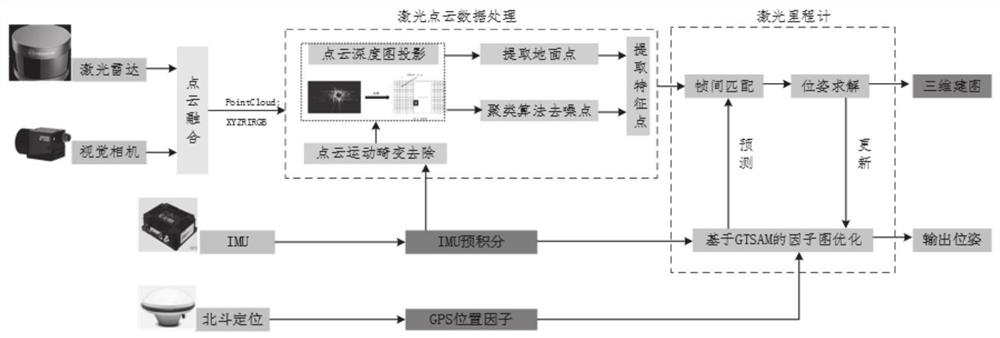
[0049] Such as figure 1 As shown, Embodiment 1 of the present disclosure provides a SLAM-based mobile robot mine scene reconstruction method, including the following process:

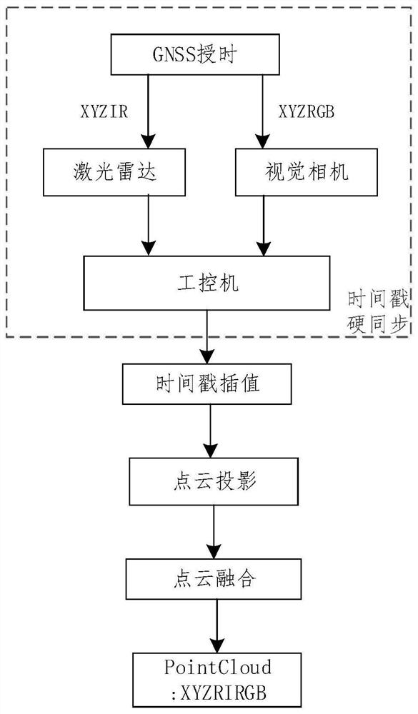
[0050] S1: Synchronize and calibrate laser point cloud and visual point cloud by using time stamp, and define a new data structure to realize point cloud data fusion.

[0051]S2: Use the multi-line laser radar and IMU fusion to remove the motion distortion of the laser point cloud and filter the point cloud for the mine scene;

[0052] S3: Using a multi-constraint factor graph algorithm based on graph optimization, IMU, laser radar, GNSS, and other constraint information are added to the constraint subgraph to realize back-end loopback detection and map building.

[0053] In S1, it mainly includes the following contents:

[0054] Synchronize and calibrate the laser point cloud and visual point cloud by using the timestamp, and define a new data structure to achieve point cloud data fusion, such as f...

Embodiment 2

[0076] Embodiment 2 of the present disclosure provides a SLAM-based mobile robot mine scene reconstruction system, including:

[0077] The data acquisition module is configured to: acquire synchronously calibrated laser point cloud data and visual point cloud data measured by the mobile robot;

[0078] The point cloud fusion module is configured to: fuse the acquired laser point cloud data and visual point cloud data;

[0079] The point cloud data processing module is configured to: perform point cloud motion distortion removal processing and point cloud filtering processing on the fused point cloud data;

[0080] The 3D map reconstruction module is configured to: combine the processed point cloud data, adopt a multi-constraint factor graph algorithm based on graph optimization, add IMU pre-integration data, point cloud key frame data and GNSS data into the constraint subgraph, and perform loop closure detection Then get the reconstructed 3D map.

[0081] The working method ...

Embodiment 3

[0083] Embodiment 3 of the present disclosure provides a computer-readable storage medium on which a program is stored, and when the program is executed by a processor, the steps in the method for reconstructing a mine scene based on SLAM for a mobile robot as described in Embodiment 1 of the present disclosure are implemented. .


PUM


Abstract

The invention provides a mobile robot mine scene reconstruction method and system based on SLAM. The method comprises the following steps: acquiring laser point cloud data and visual point cloud data measured by a mobile robot and calibrated synchronously; fusing the obtained laser point cloud data and visual point cloud data; carrying out point cloud motion distortion removal processing and point cloud filtering processing on the fused point cloud data; adding IMU pre-integration data, point cloud key frame data and GNSS data into a constraint sub-graph by combining the processed point cloud data and adopting a multi-constraint factor graph algorithm based on graph optimization, and performing loopback detection to obtain a reconstructed three-dimensional map. According to the invention, three-dimensional reconstruction in the mine scene can be effectively realized, the point cloud map with colors is finally obtained, and the precision of mine scene reconstruction is improved.

Description

technical field [0001] The present disclosure relates to the technical field of scene reconstruction, in particular to a SLAM-based mobile robot mine scene reconstruction method and system. Background technique [0002] The statements in this section merely provide background information related to the present disclosure and may not necessarily constitute prior art. [0003] With the advent of the 5G era and the unmanned driving era, Simultaneous Localization and Mapping (SLAM) technology has been widely used in unmanned driving positioning, high-precision map collection, AR (Augmented Reality, augmented reality), surveying and mapping, etc. application. [0004] The inventors found that in the mine environment, due to the large amount of dust and floating particles in the air, the data collection of lidar and visual sensors is not accurate, which greatly restricts the application of SLAM in mine scenarios; in addition, lidar can only obtain The distance information and li...

Claims


Application Information

Patent Timeline
Patent Type & Authority Applications(China)
IPC IPC(8): G06T17/05G06T7/80G06T5/50G06T5/20G06T5/00
CPCG06T17/05G06T5/50G06T5/006G06T5/20G06T7/85G06T2207/10028G06T2207/20221Y02T10/40
Inventor 周军赵一凡欧金顺皇攀凌孟广辉高新彪李留昭林乐彬
Owner SHANDONG UNIV
Why Eureka
Try Eureka