Method for detecting landform of mangrove forest based on Landsat satellite remote sensing

A technology of satellite remote sensing and satellite remote sensing data, applied in the field of satellite remote sensing and computer vision, can solve the problems of reducing time and energy, unbalanced samples, etc., and achieve the effect of reducing the amount of parameters and strong effectiveness

Inactive Publication Date: 2021-10-01
EAST CHINA NORMAL UNIV
View PDF4 Cites 5 Cited by
  • Summary
  • Abstract
  • Description
  • Claims
  • Application Information

AI Technical Summary

Problems solved by technology

[0004] The purpose of the present invention is to propose a method for detecting mangrove landforms based on Landsat satellite remote sensing in view of the deficiencies in the prior art. It adopts a variety of effective feature extraction methods and end-to-end training methods, and the obtained model has end-to-end redness. For forest identification and prediction, there is no limit to the size of the input Landsat satellite remote sensing data, which not only reduces the time and energy invested, but also has good performance, and can accurately monitor the growth

Method used


Image

  • Method for detecting landform of mangrove forest based on Landsat satellite remote sensing
  • Method for detecting landform of mangrove forest based on Landsat satellite remote sensing
  • Method for detecting landform of mangrove forest based on Landsat satellite remote sensing

Examples


Embodiment 1

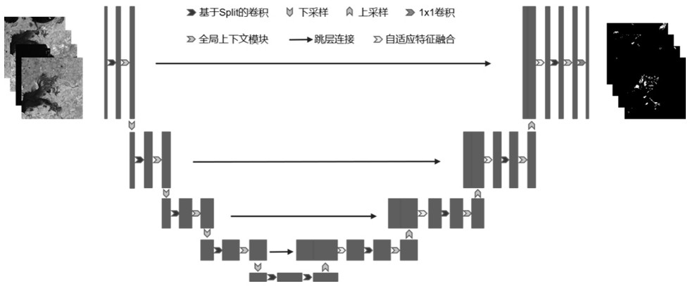
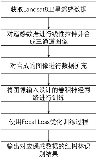
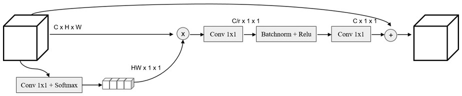
[0022] See attached figure 1 , the present invention uses the remote sensing data formed by Landsat satellites to obtain Landsat satellite remote sensing data containing a large number of mangrove landforms, and performs linear stretching to synthesize three-channel images. Perform a series of data enhancement processing on remote sensing images, and then design a convolutional neural network based on UNet to identify mangroves, integrate the attention mechanism GC Block, replace separable convolution, and use the ASFF strategy to fuse deep and shallow features. Focal Loss is used to solve the problem of sample imbalance during training, and finally the result of mangrove recognition can be output based on the input Landsat satellite remote sensing image.

[0023] See attached figure 2 , the concrete operation of the present invention is carried out according to the following steps:

[0024] (1) Processing and enhancement methods of satellite remote sensing data

[0025] F...


PUM


Abstract

The invention discloses a method for detecting the landform of a mangrove forest based on Landsat satellite remote sensing, which is characterized in that a plurality of effective feature extraction means and an end-to-end training method are adopted, an obtained model has an end-to-end mangrove forest identification prediction function, and the method specifically comprises the following steps of data acquisition and expansion, network design, network training and output and the like. Compared with the prior art, the method has the advantages that the size of the input Landsat satellite remote sensing data is not limited, the growth condition and dynamic condition of mangrove forest vegetation can be accurately monitored, the identification efficiency and precision are high, the method is simple and convenient, and the effectiveness is high.

Description

technical field [0001] The invention relates to the technical field of satellite remote sensing and computer vision, in particular to a method for detecting mangrove landforms based on Landsat satellite remote sensing. Background technique [0002] Mangroves are wetland woody plant communities that grow in the intertidal zone of tropical and subtropical coasts and are composed of evergreen trees or shrubs mainly composed of mangroves. It has the reputation of "Coast Guard" and "Ocean Green Lung". It is also an important habitat for rare and endangered waterfowl, and a breeding ground for fish, shrimp, crab, and shellfish. It is reported that 35% of the mangrove forests in the world have disappeared, and it is still decreasing at a rate of 1-2% per year. In order to better protect the mangrove ecosystem, accurately grasp the growth and dynamics of mangrove vegetation, and monitor mangrove species The spatial distribution is very necessary. However, the density of species in...

Claims


Application Information

Patent Timeline
IPC IPC(8): G06K9/00G06K9/62G06N3/04
CPCG06N3/045G06F18/253
Inventor 胡文心董怡超龙楚琪戴志军
Owner EAST CHINA NORMAL UNIV
Why Eureka
Try Eureka