Mining area long-time-sequence surface soil water content remote sensing data production method and system

A surface soil and remote sensing data technology, which is applied in the field of ecology, remote sensing and geographic information, and mining fields. It can solve the problem of inability to obtain long-term monitoring data of surface soil moisture content, electromagnetic wave length, and active microwave that cannot meet the long-term sequence of mining scenes. requirements and other issues

Inactive Publication Date: 2021-11-02
CHINA UNIV OF MINING & TECH (BEIJING) +3
View PDF7 Cites 4 Cited by
  • Summary
  • Abstract
  • Description
  • Claims
  • Application Information

AI Technical Summary

Problems solved by technology

For the monitoring of surface soil moisture content, traditional monitoring methods are ground monitoring methods based on gravity, electromagnetic, etc. Although the accuracy obtained by such methods is relatively accurate, it is time-consuming and labor-intensive, and the obtained data is point data, so it is impossible to obtain a comprehensive Mining area data, and its historical data cannot be obtained, and the mining of mineral resources in the mining area has a long time period, so this method has great limitations
The rise of remote sensing technology has provided technical support for the monitoring of surface soil water content in mining areas. However, optical thermal infrared remote sensing is easily affected by cloud and rain weather, and it is difficult to obtain continuous and effective monitoring data of surface soil water content in mining areas; Longer, the spatial resolution of surface soil moisture monitoring data is rough (mostly 20-40 kilometers), which is not suitable for mining scenarios, and active microwave cannot meet the long time series requirements of mining scenarios
Therefore, the current common methods cannot obtain long-term surface soil moisture monitoring data suitable for mining scenarios.

Method used


Image

  • Mining area long-time-sequence surface soil water content remote sensing data production method and system
  • Mining area long-time-sequence surface soil water content remote sensing data production method and system
  • Mining area long-time-sequence surface soil water content remote sensing data production method and system

Examples


Embodiment 1

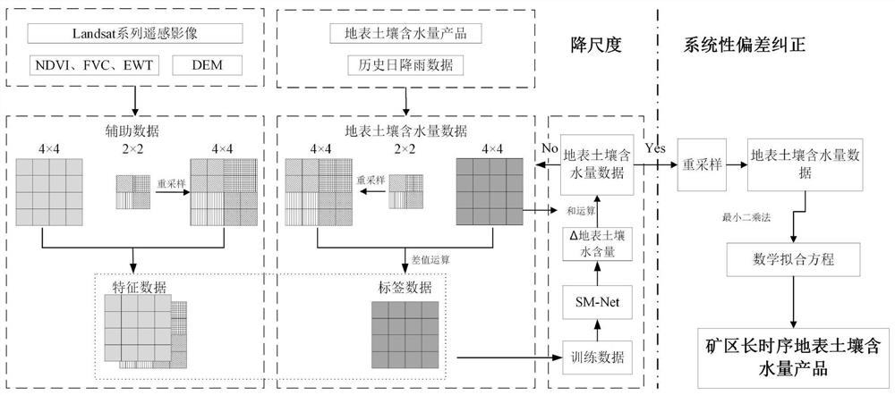
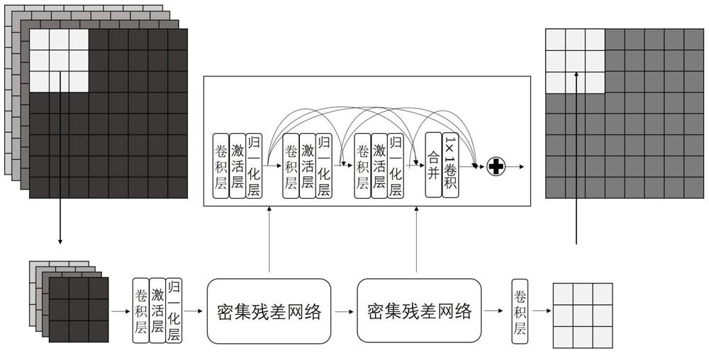
[0040] Such as Figure 1 ~ Figure 2 As shown, a mining area long-series surface soil water content remote sensing data production method, the method is as follows:

[0041] A. Determine the target mining area, and the collection includes ESA CCI V06.1, SMMR satellite sensor, TMI satellite sensor, Aquarius satellite radiometer, SMAP satellite radiometer, AMSR-E satellite sensor, AMSR2 satellite sensor, MIRAS sensor, MWRI sensor, WindSAT sensor The original historical data of the target mining area obtained from the surface soil moisture content product, set the initial year for screening the surface soil moisture content product, and filter the target mining area historical data after the initial year from the above surface soil moisture content product (such as the initial year It is 2010, and the historical data of the target mining area after 2010 is confirmed, and the historical data of the target mining area in August can also be screened out), and then the historical data...

Embodiment 2

[0063] Such as Figure 1 ~ Figure 2 As shown, a mining area long-series surface soil water content remote sensing data production method, the method is as follows:

[0064] A. Determine the target mining area, collect Landsat-5 / 7 / 8 satellite images of the target mining area year by year from 1990 to 2015 in August, and simultaneously collect the target mining area including the global land data assimilation system GLDAS, AMSR-E satellite sensor, and AMSR2 satellite sensor Original historical data (Of course, the original historical data of the target mining area obtained by ESA CCI V06.1, SMMR satellite sensor, TMI satellite sensor, Aquarius satellite radiometer, SMAP satellite radiometer, MIRAS sensor, MWRI sensor, and WindSAT sensor can also be collected) , historical daily rainfall data and digital elevation model DEM data. The SMMR satellite sensor of this embodiment is carried on the Nimbus-7 satellite, the TMI satellite sensor is carried on the TRMM satellite, the Aquar...


PUM


Abstract

The invention discloses a mining area long-time-sequence surface soil water content remote sensing data production method and system, and the method comprises the steps: firstly collecting original historical data of a target mining area, carrying out the screening, cutting and elimination processing, obtaining surface soil water content data, collecting the data, and respectively calculating a normalized vegetation index NDVI, a vegetation coverage FVC and a leaf equivalent water thickness EWT; and then determining a downscaling expansion multiple strategy according to the target resolution, and finally performing model training and downscaling expansion according to the downscaling expansion multiple strategy to finally obtain a surface soil water content data product similar to the target spatial resolution. A long-time-sequence, high-spatial-resolution and high-time-resolution earth surface soil water content data product which has consistency and adapts to a mining area scene can be obtained, long-time-sequence monitoring of the earth surface soil water content of the mining area can be achieved, and data support is provided for mining of an ecological environment evolution mechanism of the mining area, quantification of an activity influence range of the mining area and the like.

Description

technical field [0001] The invention relates to the fields of mining, ecology, remote sensing and geographic information, and in particular to a method and system for producing remote sensing data of long-term surface soil water content in mining areas. Background technique [0002] The mining of mineral resources has caused a strong disturbance to the ecological environment of the mining area, seriously affecting the succession and development of the local natural ecosystem. The monitoring of ecological environment quality in mining areas is a necessary prerequisite for ecological management in mining areas. As an important link connecting atmospheric water, surface water, and groundwater, surface soil moisture content is also an important part of ecological environment quality. Monitoring it has important practical significance. For the monitoring of surface soil moisture content, traditional monitoring methods are ground monitoring methods based on gravity, electromagneti...

Claims


Application Information

Patent Timeline
IPC IPC(8): G06K9/00G06K9/62G06N20/00
CPCG06N20/00G06F18/214G06F18/2411
Inventor 李军桑潇李全生张成业郭俊廷佘长超王宏鹏刘新华邢江河
Owner CHINA UNIV OF MINING & TECH (BEIJING)
Why Eureka
Try Eureka