Rapid detection and correction method for local distortion of remote sensing image along rail direction

A local distortion, remote sensing image technology, applied in image enhancement, image analysis, image data processing and other directions, can solve the problems of low detection efficiency and accuracy

A local distortion, remote sensing image technology, applied in image enhancement, image analysis, image data processing and other directions, can solve the problems of low detection efficiency and accuracy

CN113643240APending Publication Date: 2021-11-12CHINA CENT FOR RESOURCES SATELLITE DATA & APPL

Image

  • Rapid detection and correction method for local distortion of remote sensing image along rail direction
  • Rapid detection and correction method for local distortion of remote sensing image along rail direction
  • Rapid detection and correction method for local distortion of remote sensing image along rail direction

Examples


Embodiment Construction

[0043] In the solutions provided by the embodiments of the present application, the described embodiments are only some of the embodiments of the present application, not all of the embodiments. Based on the embodiments in this application, all other embodiments obtained by persons of ordinary skill in the art without making creative efforts belong to the scope of protection of this application.

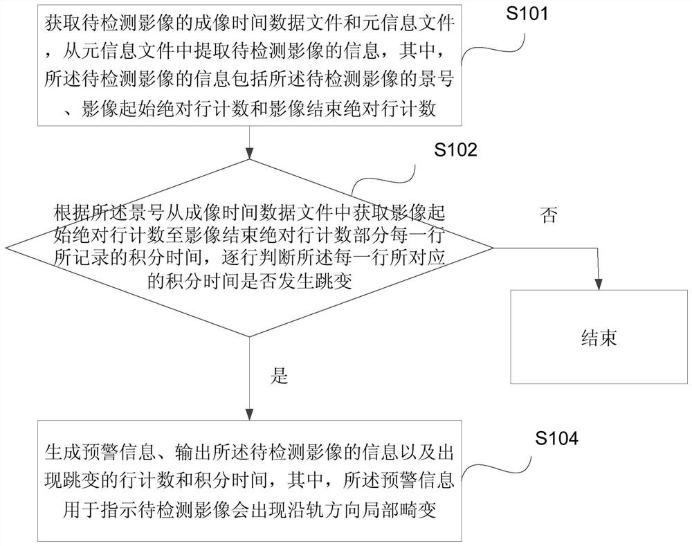
[0044] A method for rapid detection and correction of local distortion of remote sensing images along the track direction provided by the embodiment of the present application will be further described in detail below in conjunction with the accompanying drawings. The specific implementation of the method may include the following steps (the method flow is as follows: figure 1 shown):

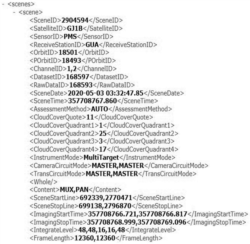
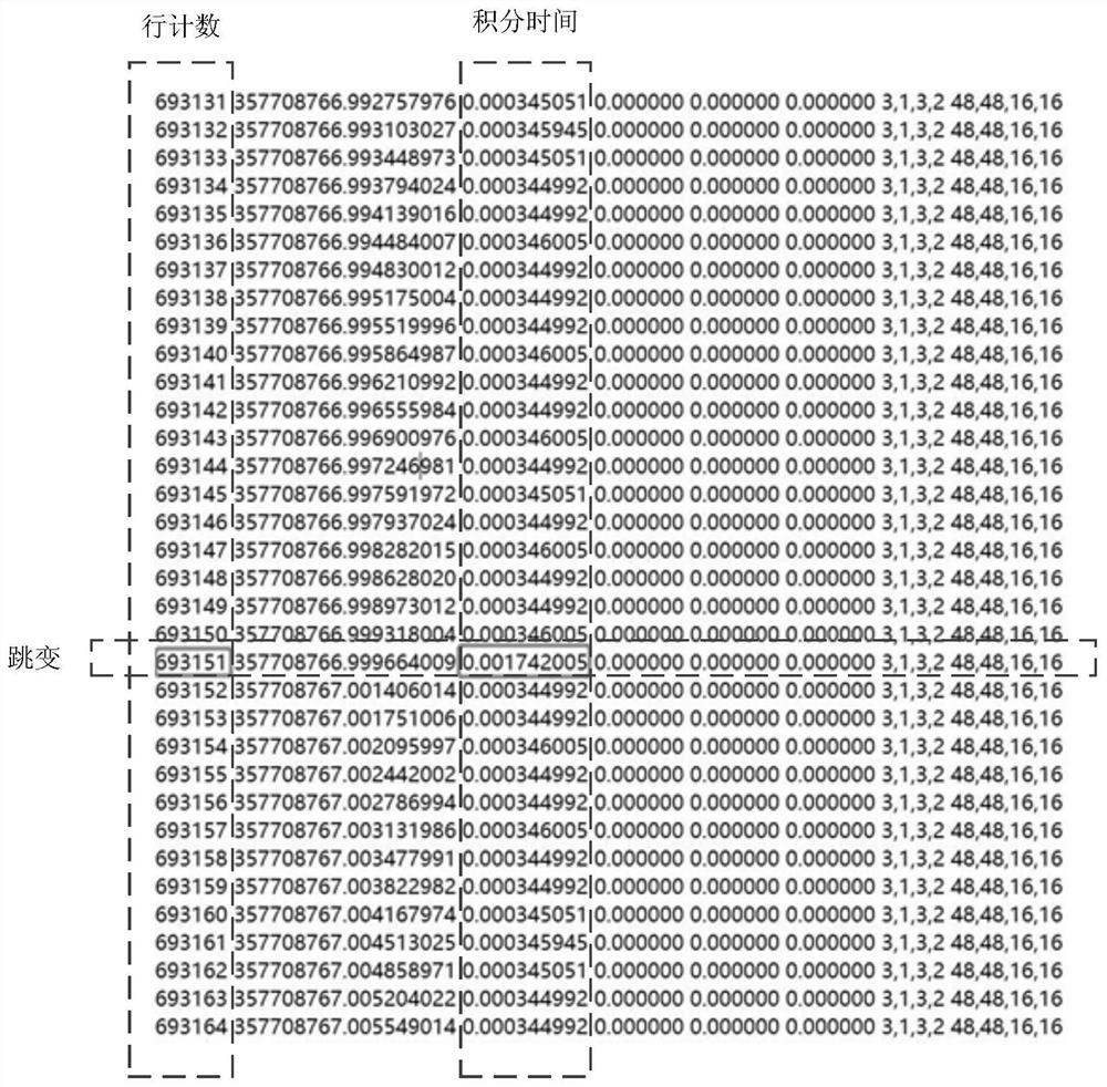
[0045] Step 101: Obtain the imaging time data file and the meta information file of the image to be detected, and extract the information of the image to be detected from the meta information file, wh...


PUM


Abstract

The invention discloses a rapid detection and correction method for local distortion of a remote sensing image along a rail direction. The method comprises the following steps: acquiring an imaging time data file and a meta-information file of a to-be-detected image; extracting information of a to-be-detected image from the meta-information file, wherein the information of the to-be-detected image comprises a scene number of the to-be-detected image, an image starting absolute line count and an image ending absolute line count; obtaining the integral time recorded in each line from the image starting absolute line counting to the image ending absolute line counting from the imaging time data file according to the scene number, and judging whether the integral time corresponding to each line jumps line by line; if the to-be-detected image jumps, early warning information is generated, outputting information of the to-be-detected image and row count and integral time of jumping, wherein the early warning information is used for indicating that local distortion of the to-be-detected image can occur in the rail direction. The technical problem of low detection efficiency and accuracy in the prior art is solved.

Description

technical field [0001] The present application relates to the technical field of remote sensing image detection, in particular to a rapid detection and correction method for local distortion of remote sensing images along the track. Background technique [0002] The Gaojing-1 satellite's Charge Coupled Device (CCD) device focal plane stitching camera uses 4 panchromatic multi-spectral five-color TDICCDs to stitch the mirrors into a straight line. According to the precise real position of each detector element in each spectral segment of each CCD device in the camera, the imaging time data, integration time data, attitude data, orbit data and scene cataloging information data of each row of images, sensor calibration is performed to construct each detector element Observation vectors, uniformly solve problems such as geometric distortion, geometric splicing, imaging time normalization, and band registration, and realize the unification of the resolution of each detector eleme...

Claims


Application Information

Patent Timeline
12 Nov 2021
Publication
CN113643240A
IPC
G06T7/00; G06T5/00
CPC
G06T7/0002; G06T2207/10032; G06T5/80; G06T5/70
Inventors
赫华颖; 郭明珠