Power grid edge layout mapping method and device based on geographic information

A technology of geographic information and layout along the grid, which is applied in the field of grid layout mapping method and device based on geographic information, can solve the problems of low drawing accuracy, low drawing efficiency, relying on manual input and maintenance, etc. The effect of reducing the number of edge crossings, reducing the number of inflection points, and improving the efficiency and accuracy of mapping

Pending Publication Date: 2021-11-16
CHINA SOUTHERN POWER GRID DIGITAL GRID RES INST CO LTD
View PDF0 Cites 0 Cited by
  • Summary
  • Abstract
  • Description
  • Claims
  • Application Information

AI Technical Summary

Problems solved by technology

[0003] In practical applications, the distribution network of the power grid is distributed along the Figure 1 Generally, business personnel use drawing tools or special drawing software for power systems to draw manually. This drawing method relies heavily on manual input and maintenance, and the drawing efficiency is low and the drawing accuracy is low.

Method used


Image

  • Power grid edge layout mapping method and device based on geographic information
  • Power grid edge layout mapping method and device based on geographic information
  • Power grid edge layout mapping method and device based on geographic information

Examples


Embodiment 1

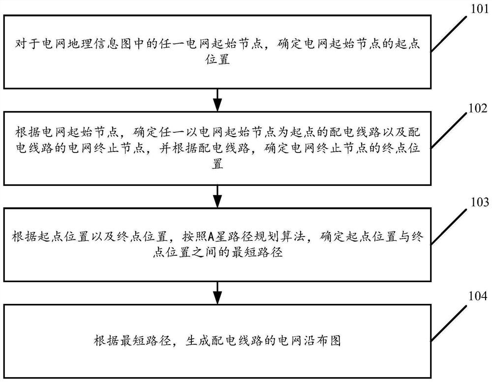
[0087] see figure 1 , figure 1 It is a schematic flowchart of a method for forming a map along the layout of a power grid based on geographical information disclosed in an embodiment of the present invention. in, figure 1 The described method can be applied to the power grid layout mapping device based on geographic information, and the power grid layout mapping device based on geographic information can be an independent device or integrated in geographic information processing equipment. The embodiments of the invention are not limited. Such as figure 1 As shown, the grid mapping method based on geographic information along the layout may include the following operations:

[0088] 101. For any grid start node in the grid geographic information map, determine the start position of the grid start node.

[0089] In the embodiment of the present invention, the grid relationship data is obtained from the grid geographic information map (GIS platform), wherein the grid re...

Embodiment 2

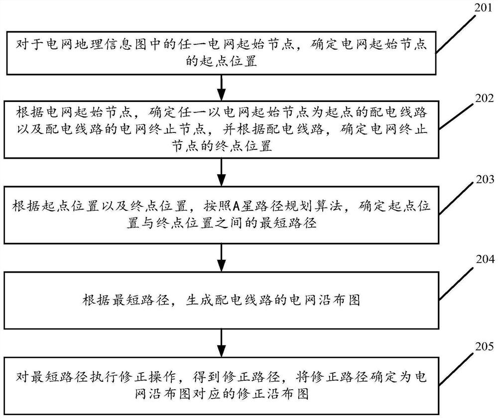
[0133] see figure 2 , figure 2 It is a schematic flow chart of another grid layout mapping based on geographical information disclosed in the embodiment of the present invention. in, figure 2 The described method can be applied to the power grid layout mapping device based on geographic information, and the power grid layout mapping device based on geographic information can be an independent device or integrated in geographic information processing equipment. The embodiments of the invention are not limited. Such as figure 2 As shown, the grid mapping method based on geographic information along the layout may include the following operations:

[0134] 201. For any grid start node in the grid geographic information map, determine the start position of the grid start node.

[0135] 202. Determine any power distribution line starting from the power grid starting node and a power grid termination node of the distribution line according to the power grid start node, and ...

Embodiment 3

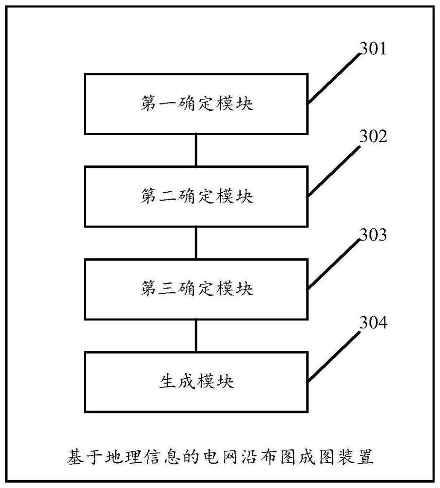
[0144] see image 3 , image 3 It is a schematic structural diagram of a power grid layout mapping device based on geographic information disclosed in an embodiment of the present invention. in, image 3 The described device can be applied to the power grid layout mapping device based on geographic information, and the power grid layout mapping device based on geographic information can be an independent device or integrated in geographic information processing equipment. The embodiments of the invention are not limited. It should be noted that the power grid layout mapping device based on geographic information refers to the steps in the method for grid layout mapping based on geographic information described in Embodiment 1 and Embodiment 2. The detailed description In this embodiment will not go into details, such as image 3 As shown, the device for forming a map along the layout of the power grid based on geographic information may include:

[0145] The first determi...


PUM


Abstract

The invention discloses a power grid edge layout mapping method and device based on geographic information. The method comprises the following steps: determining the starting position of a power grid starting node for any power grid starting node in a power grid geographic information graph; according to the power grid starting node, determining any power distribution line taking the power grid starting node as a starting point and a power grid termination node of the power distribution line, and according to the power distribution line, determining a final position of the power grid termination node; according to the starting point position and the final point position, determining a shortest path between the starting point position and the final point position according to an A star path planning algorithm; and generating a power grid edge layout of the distribution line according to the shortest path. Therefore, the method can achieve the automatic generation of the power grid edge layout based on the geographic information, and improves the generation efficiency and accuracy of the edge layout.

Description

technical field [0001] The invention relates to the technical field of power grids, in particular to a method and device for forming a grid layout along the grid based on geographic information. Background technique [0002] With the continuous construction of smart grid and distribution network system, the maintenance cost of power grid graphics continues to increase. The grid distribution network along the layout has become an important platform and means to show the operation status of the distribution network, and it is also a must for maintenance and infrastructure departments to carry out work Indispensable information. [0003] In practical applications, the distribution network of the power grid is distributed along the Figure 1 Generally, business personnel use drawing tools or special drawing software for power systems to draw manually. This drawing method relies heavily on manual input and maintenance, and the drawing efficiency is low and the drawing accuracy is...

Claims


Application Information

Patent Timeline
Patent Type & Authority Applications(China)
IPC IPC(8): G06T11/20G06Q10/04G06Q50/06
CPCG06T11/206G06Q10/047G06Q50/06
Inventor 蔡文婷
Owner CHINA SOUTHERN POWER GRID DIGITAL GRID RES INST CO LTD
Why Eureka
Try Eureka