Eureka AIR delivers breakthrough ideas for toughest innovation challenges, trusted by R&D personnel around the world.

Beach soil environment detection method and system for surveying and mapping, storage medium and intelligent terminal

An environmental detection and environmental technology, applied in surveying and navigation, measuring devices, measuring instruments, etc., can solve problems such as deviations in the position of characteristic parameters, achieve the effect of shortening time and improving detection efficiency

Pending Publication Date: 2021-11-19
诚邦测绘信息科技(浙江)有限公司
View PDF1 Cites 0 Cited by
  • Summary
  • Abstract
  • Description
  • Claims
  • Application Information

AI Technical Summary

Problems solved by technology

[0004] In view of the above-mentioned related technologies, the inventor believes that when the UAV is surveying and mapping the beach, the position of the surveyed and mapped characteristic parameters may have deviations, and there is still room for improvement

Method used


Image

  • Beach soil environment detection method and system for surveying and mapping, storage medium and intelligent terminal
  • Beach soil environment detection method and system for surveying and mapping, storage medium and intelligent terminal
  • Beach soil environment detection method and system for surveying and mapping, storage medium and intelligent terminal

Examples


Embodiment Construction

[0088] In order to make the purpose, technical solutions and advantages of this application clearer, the following in conjunction with the attached Figure 1-7 And embodiment, this application is described in further detail. It should be understood that the specific embodiments described here are only used to explain the present application, not to limit the present application.

[0089] The embodiments of the present invention will be further described in detail below in conjunction with the accompanying drawings.

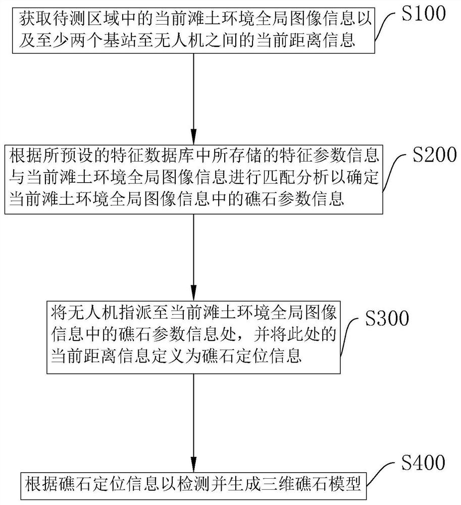
[0090] The embodiment of the present application discloses a method for detecting the beach soil environment for surveying and mapping, which uses unmanned aerial vehicles and unmanned vehicles to detect reefs in the beach soil, so that the positioning of the reefs is more accurate and the surveying and mapping images are more accurate.

[0091] refer to figure 1 , the process flow of the method for detecting the beach soil environment for surveying and mapping ...


PUM


Abstract

The invention relates to a beach soil environment detection method and system for surveying and mapping, a storage medium and an intelligent terminal and relates to the field of surveying and mapping technologies. The method comprises steps of obtaining the current beach soil environment global image information in a to-be-detected region and the current distance information between at least two base stations and an unmanned plane; performing matching analysis according to feature parameter information stored in a preset feature database and the current beach soil environment global image information to determine reef parameter information in the current beach soil environment global image information; assigning the unmanned aerial vehicle to the reef parameter information in the current beach soil environment global image information, and defining the current distance information at the reef parameter information as reef positioning information; and detecting and generating a three-dimensional reef model according to the reef positioning information. The method is advantaged in that the position of the characteristic parameter measured by the unmanned aerial vehicle is accurate.

Description

technical field [0001] The present application relates to the field of beach soil detection technology, in particular to a method, system, storage medium and intelligent terminal for detection of beach soil environment for surveying and mapping. Background technique [0002] Surveying and mapping is based on computer technology, optoelectronic technology, network communication technology, space science, and information science, with global navigation satellite positioning system (GNSS), remote sensing (RS), and geographic information system (GIS) as the technical core. The existing feature points and boundaries and the method of obtaining graphics and position information reflecting the current situation of the ground by means of measurement. When people develop the environment where the beach is located, in order to facilitate the construction of it, it is usually necessary to survey and map it to understand the land conditions before starting construction. [0003] In the...

Claims


Application Information

Patent Timeline
Patent Type & Authority Applications(China)
IPC IPC(8): G01C15/00G01C11/04
CPCG01C15/00G01C11/04
Inventor 周灵勇葛继空崔巧云葛步月宗秀文
Owner 诚邦测绘信息科技(浙江)有限公司
Why Eureka
Eureka Blog
Learn More