Earthquake casualty personnel gathering area assessment method based on unmanned aerial vehicle oblique photography

A technology for oblique photography and casualties. It is applied in computer parts, image data processing, complex mathematical operations, etc. It can solve problems such as no evaluation of the spatial distribution of casualties, and inability to quantify areas with dense casualties, achieving a wide coverage. , low cost, fast aging effect

Pending Publication Date: 2021-11-19
DALIAN UNIV OF TECH
View PDF0 Cites 4 Cited by
  • Summary
  • Abstract
  • Description
  • Claims
  • Application Information

AI Technical Summary

Problems solved by technology

However, these methods only give the discrete distribution of the number of casualties without evaluating the spatial distribution characteristics of the number of casualties, which makes it impossible to quantify the areas with dense casualties

Method used


Image

  • Earthquake casualty personnel gathering area assessment method based on unmanned aerial vehicle oblique photography
  • Earthquake casualty personnel gathering area assessment method based on unmanned aerial vehicle oblique photography
  • Earthquake casualty personnel gathering area assessment method based on unmanned aerial vehicle oblique photography

Examples


example 1

[0099] Taking the main campus of Lingshui Campus of Dalian University of Technology as an example, according to the aerial images taken by UAV obliquely, the area with dense casualties that may be caused by the earthquake is evaluated and determined.

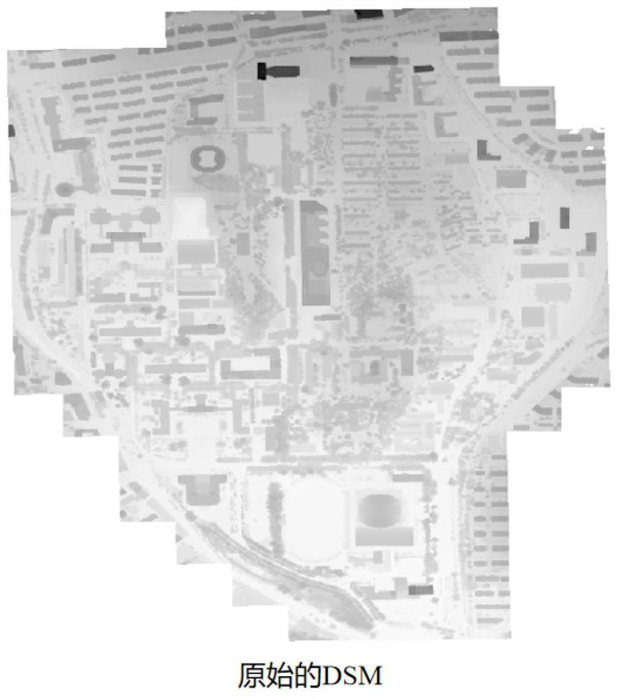
[0100] The first step is to obtain the digital orthophoto map (Digital Orthophoto Map, DOM) and digital surface model (Digital Surface Model, DSM) ( figure 1 );

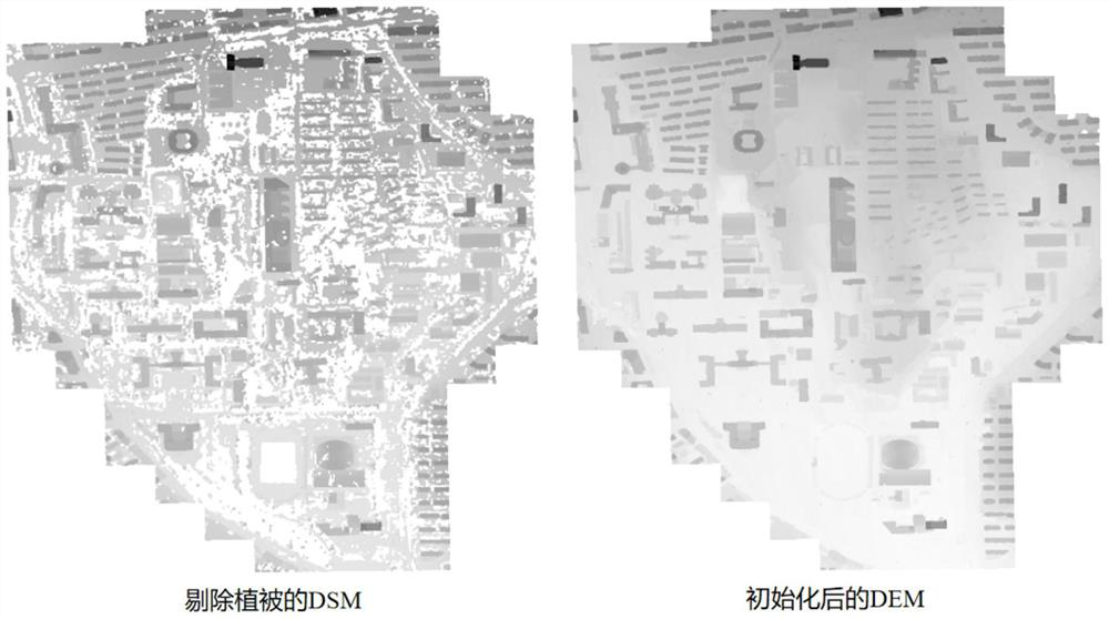
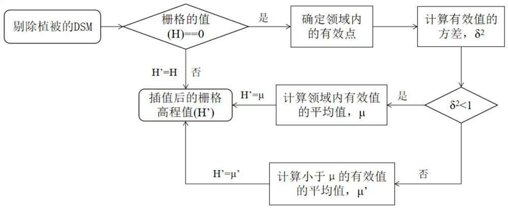
[0101] The second step is to process the data to obtain an initialized digital elevation model (Digital Elevation Model, DEM) that only retains building and ground elevations ( figure 2 );

[0102] In the third step, mean-shift unsupervised clustering is performed on the building contours extracted from the initialized DEM, and building contour clusters are identified according to the number of contours in each class. Perform profile analysis to determine building footprint and roof profile. Such as Figure 6 shown;

[0103] The fourth step is to use the determi...


PUM


Abstract

The invention belongs to the technical field of earthquake engineering, and particularly relates to an earthquake casualty personnel gathering area assessment method based on unmanned aerial vehicle oblique photography. According to the method, an unmanned aerial vehicle with an inclined camera is used for performing information acquisition on the research area, earthquake prediction simulation is performed on the building in the research area in combination with the geographic position, the geological condition and the personnel distribution condition of the area, and casualties are estimated according to the damage state of the building and the basic information of the building. The casualty hot spots are obtained by performing hot spot analysis on the casualty distribution, so that the casualty gathering area in the whole area is obtained, and spatial guidance is provided for disaster prevention planning. According to the invention, building information is automatically identified and extracted, and technical support is provided for regional building information acquisition. For evaluation of regional casualties, the number of casualties caused by a disaster body and spatial distribution are considered, and a spatial correlation analysis method is introduced to analyze spatial distribution characteristics of the casualties.

Description

technical field [0001] The invention belongs to the technical field of earthquake engineering, and in particular relates to a method for evaluating an earthquake casualty gathering area based on oblique photography of an unmanned aerial vehicle. Background technique [0002] Earthquake is a major natural disaster faced by human beings, which will cause huge casualties and economic losses. Existing research results and earthquake emergency rescue experience have shown that although there are many factors that cause death, the timeliness of rescue is closely related to the survival rate of casualties. Since the occurrence of earthquakes cannot be accurately predicted at present, the most effective way to reduce earthquake disasters is to assess the risk of earthquake disasters according to the scenario, determine the dangerous areas to rationally allocate disaster prevention materials and make disaster prevention plans. [0003] There are two difficulties in regional earthqua...

Claims


Application Information

Patent Timeline
Patent Type & Authority Applications(China)
IPC IPC(8): G06T17/10G06T7/136G06T7/62G06T7/90G06F17/16G06K9/62
CPCG06T17/10G06T7/136G06T7/62G06T7/90G06F17/16G06T2207/10012G06T2207/20021G06T2207/30181G06F18/23
Inventor 张蕾蕾王国新
Owner DALIAN UNIV OF TECH
Why Eureka
Try Eureka