Bridge investigation method

A technology of bridges and schemes, applied in the field of foundation soil survey on construction sites, can solve the problems of incompatibility, low accuracy, time-consuming and labor-intensive problems, and achieve the effects of saving costs, high accuracy, and improving survey quality

Inactive Publication Date: 2012-08-15
COMM DESIGN INST CO LTD OF JIANGXI PROV
View PDF6 Cites 15 Cited by
  • Summary
  • Abstract
  • Description
  • Claims
  • Application Information

AI Technical Summary

Problems solved by technology

This bridge survey method is time-consuming and laborious, and depends largely on the actual experience and technical level of the line selection personnel, and is not suitable for projects with relatively tight construction schedules and high requirements.
In particular, this two-dimensional method for line selection and position selection cannot be coordinated with the actual terrain and route landscape, nor can it be closely combined with actual conditions such as geological conditions. The accuracy of the drawing is not high, and the effect is not good.

Method used


Image

  • Bridge investigation method
  • Bridge investigation method

Examples


Embodiment Construction

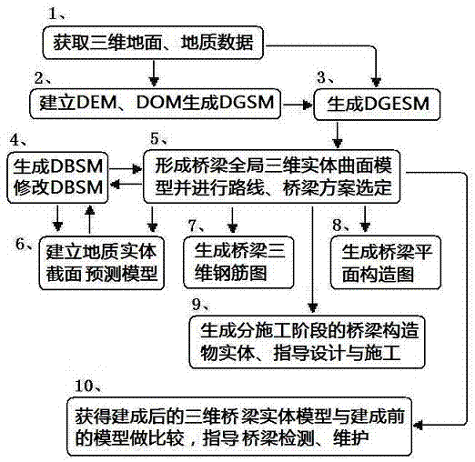
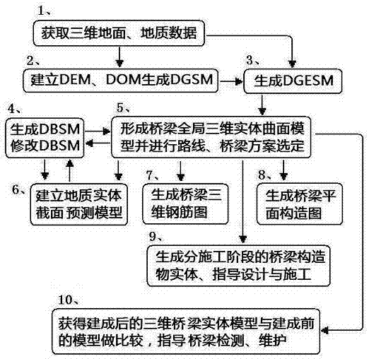
[0026] The present invention will be further described below with reference to the accompanying drawings and in conjunction with specific embodiments.

[0027] A bridge investigation method, comprising the following steps

[0028] Step 1) Obtaining data, including obtaining 3D ground data, 3D geological model data, and generating a 3D ground solid surface model;

[0029] 1-1) Obtain remote sensing, aerial survey, multi-temporal high-resolution satellite stereo images and airborne LiDAR system (Light Detection And Ranging, abbreviated as LIDAR) scanning data; the survey area should follow the route plan, and the starting point and end point should go beyond the bridge. , The position of the exit of the cave (20~100m), using aerial surveying, remote sensing with elevation data at a ratio of 1: (500~1000) topographic map or satellite imaging with a resolution of 0.2~1.0m high-resolution satellite stereoscopic image, High-resolution satellite stereo images should have rational fu...


PUM


Abstract

A bridge investigation method includes the steps of firstly, acquiring three-dimensional ground and geological data, and generating a DGSM (digital geological solid model); secondly, generating a DGESM (digital geological surface or solid model); thirdly, generating a DBSM (digital bridge solid model); fourthly, generating a bridge global three-dimensional solid surface model; fifthly, subjecting the bridge global three-dimensional solid surface model to bridge structure solid mechanical analysis, and selecting road alignment schemes and bridge schemes; sixthly, establishing a geological solid sectional prediction model, and optimizing road and bridge schemes; seventhly, using the bridge global three-dimensional solid surface model to generate a three-dimensional steel bar diaphragm of a bridge structure; eighthly, generating structural diaphragms of superstructure and understructure of a bridge; ninthly, generating a constructional-phase solid of the superstructure and the understructure of the bridge; and tenthly, comparing an after-building three-dimensional bridge solid model to a pre-building bridge global three-dimensional solid surface model to obtain parameters such as displacement, settlement, deformation and the like for bridge detection. By the method, the bridge and geological three-dimensional conditions can be obtained directly, the road and bridge schemes can be selected accurately, visually and conveniently, rework amount can be reduced effectively, investigation quality, constructional safety and bride stability can be improved, the problem of coordination of the bridge with environment and geology is solved, and bridge design effect is improved evidently. The method is widely applicable to bridge investigation and can be applied to engineering application by configuring corresponding software.

Description

technical field [0001] The invention relates to surveying of foundation soil on construction sites, in particular to a bridge surveying method. Background technique [0002] The existing bridge survey methods include collecting and analyzing relevant design data in the bridge alignment area through surveying, selecting several possible alignment schemes on the topographic map, and reflecting the vertical and horizontal section data of different pile numbers of the bridge according to the alignment scheme. Go to the two-dimensional view, combine with the geological drilling column diagram or geological section diagram to carry out design and on-site survey, and repeatedly compare and determine the economical and reasonable horizontal and vertical alignment and bridge scheme. This bridge survey method is time-consuming and laborious, and depends largely on the actual experience and technical level of the line selection personnel, and is not suitable for projects with relativel...

Claims


Application Information

Patent Timeline
Patent Type & Authority Applications(China)
IPC IPC(8): E01D1/00E02D1/00
Inventor 朱海涛
Owner COMM DESIGN INST CO LTD OF JIANGXI PROV
Why Eureka
Try Eureka