
Method and system for data collection, visualization and calibration of roadside perception system

A technology of perception system and data collection, applied in traffic control system, transmission system, image data processing and other directions of road vehicles, can solve the problems of calibrating a single sensor, cumbersome calibration scheme, and high time cost, so as to improve the calibration efficiency and realize long-distance calibration. The effect of distance transmission

Active Publication Date: 2022-07-08
上海智能网联汽车技术中心有限公司
View PDF16 Cites 0 Cited by
  • Summary
  • Abstract
  • Description
  • Claims
  • Application Information

AI Technical Summary

Problems solved by technology

It can be seen from this that the current calibration scheme for the roadside perception system is very cumbersome, requires high technical level of operators, and has a high time cost
[0004] At the same time, the current calibration algorithms can only calibrate a single sensor, and cannot simultaneously calibrate the lidar, millimeter-wave radar, and camera in the perception system.
[0005] At present, there is no mature and complete roadside sensor automatic calibration system on the market that can simultaneously realize data collection, visualization and automatic calibration of lidar, camera and millimeter-wave radar sensors

Method used


Image

  • Method and system for data collection, visualization and calibration of roadside perception system
  • Method and system for data collection, visualization and calibration of roadside perception system

Examples


Embodiment 1

[0060] A method for data collection, visualization and calibration of a roadside perception system provided according to the present invention includes:

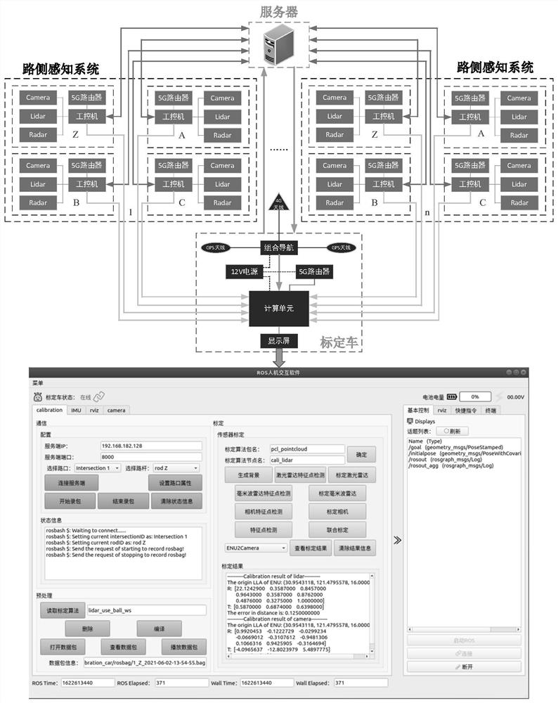
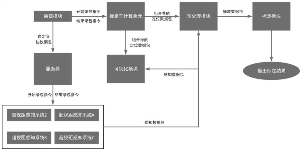
[0061] Step S1: When the calibration vehicle terminal performs the start packet recording operation, the calibration vehicle terminal uses UDP communication to issue a packet recording start instruction to the server, and the server forwards the packet recording start instruction to the road-end over-the-horizon perception to be calibrated in the custom message protocol System, the over-the-horizon perception system starts the packet recording operation and records the sensing result data of each sensor. When the over-the-horizon perception system starts to perform the packet recording operation, the calibration vehicle immediately starts the packet recording operation and records the positioning of the integrated navigation on the calibration vehicle. data;

[0062] Step S2: when the calibration vehicle end performs the end...

Embodiment 2

[0103] Embodiment 2 is a preferred example of Embodiment 1

[0104] The invention realizes the original data collection and visualization of the calibration vehicle end and the roadside perception system end through the visual interface operation, and realizes the automatic calibration of the laser radar, the millimeter-wave radar and the camera in the perception system, and outputs the calibration result; realizes the calibration of the vehicle by using UDP communication. The transmission of control instructions from the terminal, the server and the roadside sensing terminal, so as to realize the automatic collection and storage of the positioning data of the calibrated vehicle and the sensing data of each sensor on the roadside sensing terminal, and realize the long-distance transmission of the roadside terminal data at the same time; realize integrated navigation Visualize the positioning data and the perception data of the roadside perception system; realize the absolute an...


PUM


Abstract

The invention provides a method and system for data collection, visualization and calibration of a roadside perception system. Forward the start packet recording command to the road-end beyond-the-horizon sensing system to be calibrated in the custom message protocol. At the same time as the package operation, the calibration vehicle immediately starts the packet recording operation, and records the positioning data of the integrated navigation on the calibration vehicle; according to the recorded sensing result data of each sensor on the roadside and the absolute positioning data of the calibration vehicle, the calibration algorithm is used to realize the super vision. Calibration of laser radar, millimeter wave radar and camera included in the distance sensing system; the invention can realize the collection of data of multiple intersection sensing systems at one time, and realize the calibration of each sensor at each intersection.

Description

technical field [0001] The present invention relates to the technical field of roadside perception systems, in particular, to a method and system for data collection, visualization and calibration of roadside perception systems, and more particularly, to a method and system for data collection, visualization and calibration of roadside perception systems Integrated system solution. Background technique [0002] Patent document CN110853393B (application number: 201911176850.6) discloses a method and system for data collection and fusion of an intelligent networked vehicle test field. The method includes: step 1, constructing a test field map according to the collected static data in the test field In step 2, the roadside dynamic data acquisition module tracks the dynamic target within the perception range, and generates the track data management file under the corresponding label; in step 3, obtains the position of the self-vehicle through the vehicle-end dynamic data acquisi...

Claims


Application Information

Patent Timeline
Patent Type & Authority Patents(China)
IPC IPC(8): G08G1/01H04L67/12H04L69/164G06T7/80
CPCG08G1/0104H04L67/12H04L69/164G06T7/80G06T2207/10028
Inventor 李波张宇超高瑞金王秋原张雷波
Owner 上海智能网联汽车技术中心有限公司
Features
  • Generate Ideas
  • Intellectual Property
  • Life Sciences
  • Materials
  • Tech Scout
  • Unparalleled Data Quality
  • Higher Quality Content
  • 60% Fewer Hallucinations
Learn More