
Glacier and accumulated snow automatic extraction method and system based on remote sensing image

A remote sensing image, automatic extraction technology, applied in the field of remote sensing measurement, can solve the problem of low recognition accuracy of glaciers and snow, achieve the effect of accurate extraction and avoid wrong extraction

Pending Publication Date: 2021-12-21
青海省地质调查院青海省地质矿产研究院青海省地质遥感中心 +1
View PDF0 Cites 4 Cited by
  • Summary
  • Abstract
  • Description
  • Claims
  • Application Information

AI Technical Summary

Problems solved by technology

[0006] Aiming at the problems in related technologies, the present invention proposes a method and system for automatically extracting glaciers and snow cover based on remote sensing images, which analyzes the characteristics of ground features from multi-dimensional features, effectively integrates DEM and spectral information, and avoids the single feature dimension, which causes Low identification accuracy of glaciers and snow; at the same time, comprehensively using snow cover index method and decision tree algorithm, on the basis of snow cover index method extraction, with the advantage of decision tree algorithm that can simultaneously process data type and conventional type attributes, mining Extraction rules of glaciers and snow to improve the accuracy of glacier and snow extraction

Method used


Image

  • Glacier and accumulated snow automatic extraction method and system based on remote sensing image
  • Glacier and accumulated snow automatic extraction method and system based on remote sensing image
  • Glacier and accumulated snow automatic extraction method and system based on remote sensing image

Examples


Embodiment Construction

[0043]The following will clearly and completely describe the technical solutions in the embodiments of the present invention with reference to the accompanying drawings in the embodiments of the present invention. Obviously, the described embodiments are only some, not all, embodiments of the present invention. All other embodiments obtained by persons of ordinary skill in the art based on the embodiments of the present invention belong to the protection scope of the present invention.

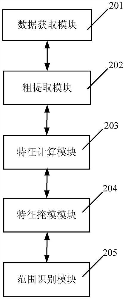
[0044] According to an embodiment of the present invention, a method and system for automatically extracting glaciers and snow cover based on remote sensing images are provided.

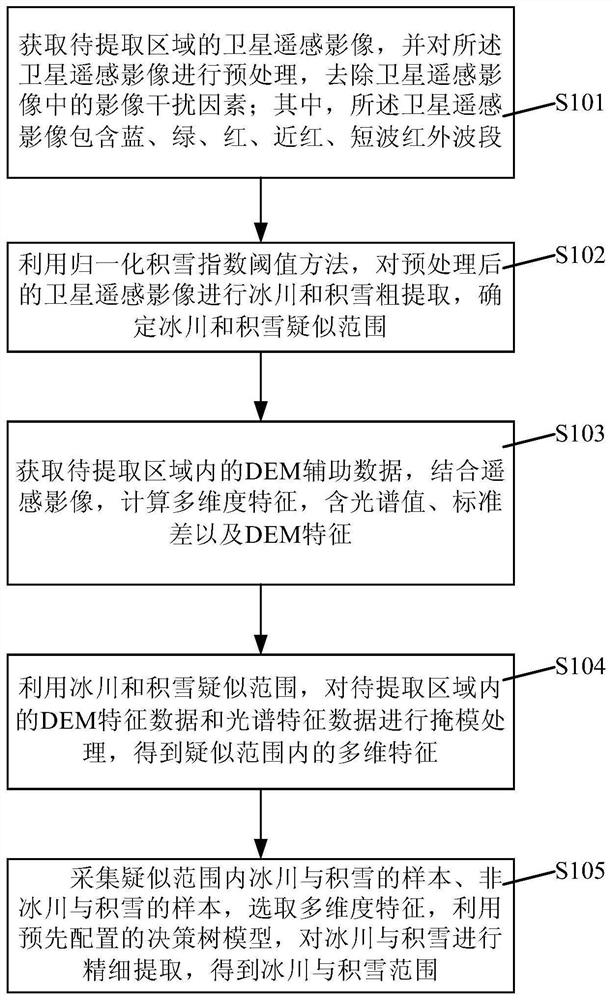
[0045] Such as figure 1 As shown, a method for automatically extracting glaciers and snow cover based on remote sensing images according to an embodiment of the present invention includes the following steps:

[0046] Step S101, acquire the satellite remote sensing image of the area to be extracted, and preprocess t...


PUM


Abstract

The invention discloses a glacier and accumulated snow automatic extraction method based on a remote sensing image, and the method comprises the following steps: obtaining a satellite remote sensing image of a to-be-extracted region, and preprocessing the satellite remote sensing image; performing glacier and accumulated snow crude extraction on the preprocessed satellite remote sensing image by using a normalized accumulated snow index threshold method, and determining a suspected range; acquiring DEM auxiliary data of a to-be-extracted area, calculating multidimensional features including spectral values, standard deviations and DEM features in combination with the remote sensing image; performing mask processing on the multi-dimensional features in the to-be-extracted area by using the glacier and snow suspected range to obtain multi-dimensional features in the suspected range; collecting samples in a suspected range, selecting multi-dimensional features, and using a decision tree model to realize fine extraction of glacier and accumulated snow.

Description

technical field [0001] The invention relates to the technical field of remote sensing measurement, in particular to a method and system for automatically extracting glaciers and snow cover based on remote sensing images. Background technique [0002] Glaciers and snow cover are important freshwater resources on the surface, and generally exist in high-latitude areas or alpine areas in mid-low latitudes. In remote sensing images, glaciers and snow cover appear as snow cover types. Different from other ground cover types, snow cover has unique spectral characteristics, showing high reflectivity in the visible light range, and high reflectivity in the near-infrared range. This spectral characteristic of snow cover is the physical basis for optical remote sensing monitoring of snow cover. [0003] At present, the commonly used snow extraction methods are: 1) band calculation extraction; band calculations include band ratio method and normalized snow index method. 2) Extraction...

Claims


Application Information

Patent Timeline
Patent Type & Authority Applications(China)
IPC IPC(8): G06K9/00G06K9/46G06K9/62
CPCG06F18/24323
Inventor 张焜张晓博刘世英李咏洁李晓韵李延峰
Owner 青海省地质调查院青海省地质矿产研究院青海省地质遥感中心
Learn More