
Complex terrain three-dimensional scanning radar wind measurement system, method and equipment

A technology of three-dimensional scanning and complex terrain, which is applied in the direction of radio wave measurement system, measurement device, electromagnetic wave reradiation, etc., can solve the problem of poor wind measurement accuracy and achieve the effect of reliable data support

Pending Publication Date: 2021-12-24
HUANENG NEW ENERGY CO LTD +3
View PDF0 Cites 0 Cited by
  • Summary
  • Abstract
  • Description
  • Claims
  • Application Information

AI Technical Summary

Problems solved by technology

[0003] The purpose of the present invention is to provide a complex terrain three-dimensional scanning radar wind measurement system, method and equipment, which solves the existing defects of poor wind measurement accuracy for complex terrain positions

Method used


Image

  • Complex terrain three-dimensional scanning radar wind measurement system, method and equipment
  • Complex terrain three-dimensional scanning radar wind measurement system, method and equipment
  • Complex terrain three-dimensional scanning radar wind measurement system, method and equipment

Examples


Embodiment Construction

[0027] The present invention will be described in detail below with reference to the accompanying drawings and examples. It should be noted that, in the case of no conflict, the embodiments in the present application and the features in the embodiments can be combined with each other.

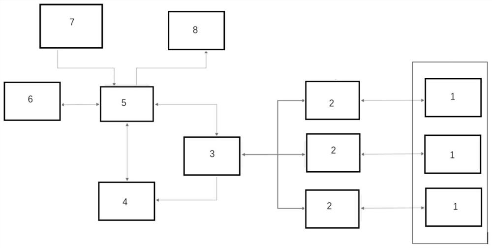
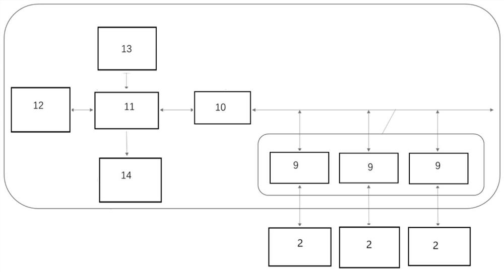
[0028] Such as Figure 1 to Figure 3 As shown, a kind of complex terrain three-dimensional scanning radar wind measurement system proposed by the present invention includes three-dimensional scanning radar 1, wind measurement module control cabinet 2, CAN bus controller 3, first industrial computer 5, data acquisition module 4, remote control Module 6, data external input module 7, data external output module 8, wherein:

[0029] There are three three-dimensional scanning radars 1, and the three three-dimensional scanning radars 1 are arranged in a triangular structure.

[0030] Each three-dimensional scanning radar 1 is connected with a wind measurement module control cabinet 2 .

[0031] E...


PUM


Abstract

The invention provides a complex terrain three-dimensional scanning radar wind measurement system, method and equipment. The system comprises three-dimensional scanning radars used for collecting the radial wind speed at a to-be-measured point; and a first industrial personal computer used for sending a start-stop instruction to the three-dimensional scanning radar and calculating the second-level horizontal wind speed and the vertical wind speed of the to-be-measured point according to the radial wind speed collected by the three-dimensional scanning radars. The number of the three-dimensional scanning radars is three, and the three three-dimensional scanning radars are all in communication connection with the first industrial personal computer. According to the system, more accurate meteorological data can be obtained, and more reliable data support is provided for a wind power plant during wind resource measurement.

Description

technical field [0001] The invention belongs to the technical field of wind power generation, and in particular relates to a complex terrain three-dimensional scanning radar wind measurement system, method and equipment. Background technique [0002] Current lidar wind measurement is a relatively high-precision telemetry technique. The laser radar system emits a high-spectrum-purity laser beam into the detection airspace, and the aerosol particles in the atmosphere interact elastically with the laser beam. After the backscattered echo optical signal is effectively received by the radar signal transceiver system, it passes through the high-sensitivity optical frequency heterodyne The detection technology can accurately invert the measured Doppler spectrum information to obtain wind field information such as wind speed and wind direction. At present, the lidar on the market has been approved for wind measurement in flat terrain, but due to the limitation of its principle, the...

Claims


Application Information

Patent Timeline
Patent Type & Authority Applications(China)
IPC IPC(8): G01S17/95
CPCG01S17/95Y02A90/10
Inventor 卢坤鹏刘鑫闫姝张波叶昭良陈新明尹铁男孙少华屠劲林李芳富冯笑丹
Owner HUANENG NEW ENERGY CO LTD
Learn More