Vehicle-unmanned aerial vehicle multi-target cooperative path planning method

A path planning, drone technology, applied in vehicle position/route/altitude control, non-electric variable control, instruments, etc., can solve problems such as increasing complexity, and achieve the effect of high customer satisfaction

Pending Publication Date: 2021-12-28
CENT SOUTH UNIV
View PDF6 Cites 2 Cited by
  • Summary
  • Abstract
  • Description
  • Claims
  • Application Information

AI Technical Summary

Problems solved by technology

Since the cooperative vehicle routing problem is an NP-hard problem, considering multiple targets and multiple UAVs significantly increases the complexity of solving an already difficult problem
Therefore, it is still challenging to solve the multi-objective cooperative path planning problem under multi-UAV and complex constraints.

Method used


Image

  • Vehicle-unmanned aerial vehicle multi-target cooperative path planning method
  • Vehicle-unmanned aerial vehicle multi-target cooperative path planning method
  • Vehicle-unmanned aerial vehicle multi-target cooperative path planning method

Examples


Embodiment Construction

[0041] Below in conjunction with accompanying drawing, the present invention will be further described, but the present invention is not limited in any way, and any transformation or replacement done based on the teaching of the present invention belongs to the protection scope of the present invention.

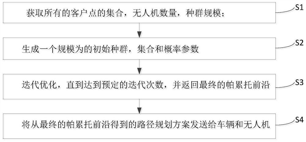
[0042] Such as figure 1 As shown, the vehicle-unmanned aerial vehicle multi-objective collaborative path planning method disclosed in the present invention comprises the following steps:

[0043] Obtain the set C of all customer points, the number of drones m, and the population size n;

[0044] Generate an initial population P of size n 1 , set PF and probability parameters;

[0045] Start iterative optimization: in each iteration, generate the offspring population Q based on the genetic operator t , and combine it with the parent population P t merge; use the perturbation strategy to merge the population R t Repeated solutions in ; perform non-dominated sorting in the ...


PUM


Abstract

The invention discloses a vehicle-unmanned aerial vehicle multi-target cooperative path planning method. The method comprises the following steps: acquiring a set of all client points and the number of unmanned aerial vehicles; generating an initial population, a set PF and a probability parameter; starting iterative optimization: in each iteration, generating a filial generation population based on a genetic operator, and combining the filial generation population with a parent population; combining repeated solutions in the population by using a disturbance strategy; executing non-dominated sorting; updating the Pareto frontier, performing Pareto local search on the solution in the PF, and replacing the Pareto frontier with the searched PF; executing crowding degree calculation and a squeezing strategy; selecting a proper solution to enter a next generation population; carrying out iteration until a final Pareto front is returned; and sending the path planning scheme to the vehicle and the unmanned aerial vehicle. Experimental results prove that the method has performance superiority and parameter sensitivity. A method for searching an optimal compromise scheme is provided for decision making of logistics enterprises.

Description

technical field [0001] The invention belongs to the technical field of logistics distribution, and in particular relates to a vehicle-unmanned aerial vehicle multi-objective collaborative path planning method. Background technique [0002] In recent years, small drones have been widely used in express delivery services. The flying speed of drones is faster than that of vehicles, and it is not restricted by road conditions, which can greatly reduce the cost and time of delivering packages. However, UAVs have some disadvantages, such as short flight distance and limited capacity, etc. Vehicle-UAV collaborative delivery system combines the advantages of UAV and vehicle. In this system, when a vehicle travels between different customer nodes, a drone launched from the vehicle can simultaneously provide services to nearby customer nodes. Especially for some customer nodes that cannot be served by vehicles due to road conditions (such as traffic congestion), drones can effectiv...

Claims


Application Information

Patent Timeline
IPC IPC(8): G05D1/10
CPCG05D1/104Y02T10/40
Inventor 伍国华罗启章
Owner CENT SOUTH UNIV
Why Eureka
Try Eureka