Landslide deformation monitoring method and visual service platform

A service platform and deformation technology, applied in the field of remote sensing, can solve problems such as heavy workload, high cost, and low precision

Pending Publication Date: 2022-01-04
NINGXIA UNIVERSITY
View PDF0 Cites 5 Cited by
  • Summary
  • Abstract
  • Description
  • Claims
  • Application Information

AI Technical Summary

Problems solved by technology

[0011] An object of the present invention is to propose a landslide monitoring system method based on optical and radar data fusion based on the characteristics of the landslide area, using the a

Method used


Image

  • Landslide deformation monitoring method and visual service platform
  • Landslide deformation monitoring method and visual service platform
  • Landslide deformation monitoring method and visual service platform

Examples


Embodiment Construction

[0045] The specific implementation manners of the present invention will be further described in detail below in conjunction with the accompanying drawings and embodiments. The following examples are used to illustrate the present invention, but are not intended to limit the scope of the present invention.

[0046] No matter from the perspective of data analysis, visualization, or from the perspective of fast and high-quality service capabilities, it is imperative to establish a high-efficiency and easy-to-extend visualization platform to realize landslide disaster monitoring, rapid response, and visualization analysis. There is a low degree of coupling with the domain, and the hierarchical and componentized architecture can meet the requirements for scalability and versatility of the visualization platform software.

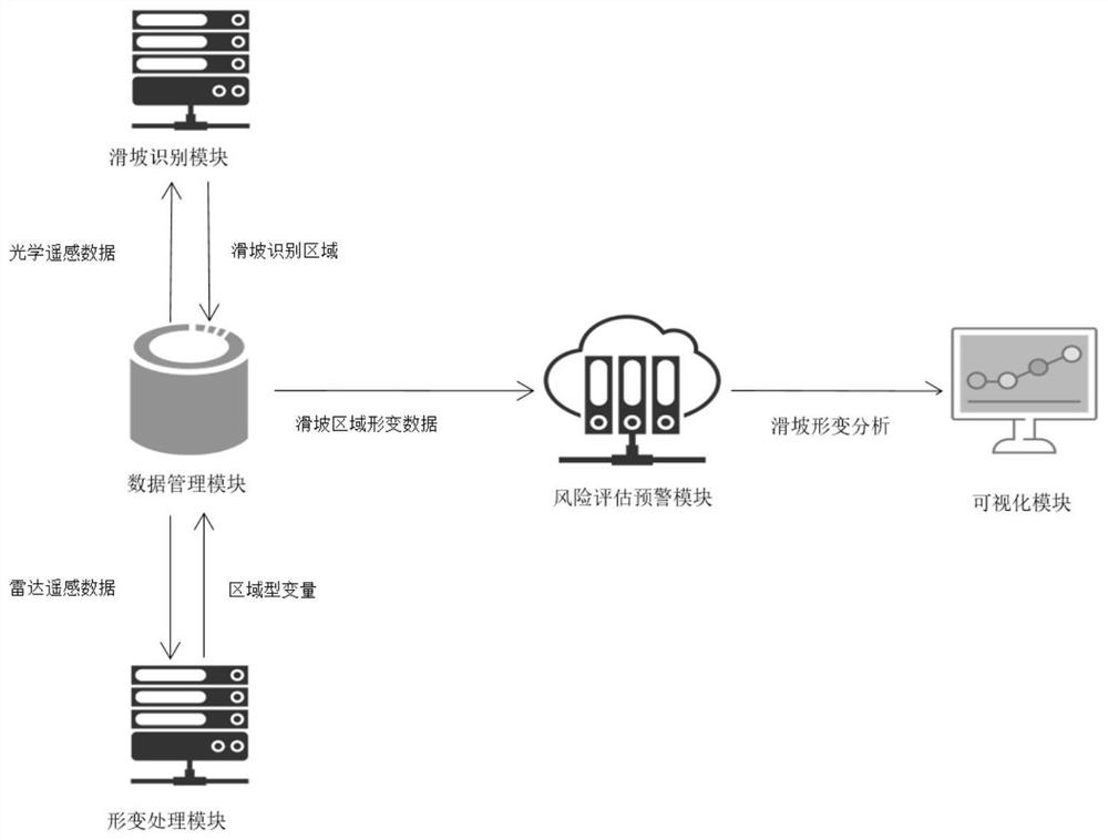
[0047] Based on this, this application proposes a rapid response and visualization service platform based on multi-source satellite remote sensing data. The pla...


PUM


Abstract

The invention relates to the technical field of remote sensing technologies, in particular relates to a landslide deformation monitoring method and a visual service platform, provides a landslide monitoring system method based on optical and radar data fusion by starting from landslide area features and utilizing the advantages brought by optical and radar image fusion, and solves the problems that a traditional landslide deformation monitoring method is low in precision, large in workload and high in cost. A landslide identification module, a deformation processing module, a risk assessment early warning module, a data management module and a visualization module are included. The landslide identification module is used for identifying a landslide area in a remote sensing image; the deformation processing module is used for extracting deformation characteristics in the landslide area; the risk assessment and early warning module is used for performing assessment and early warning on the risk of each landslide disaster; the data management module is used for storing various data in the system; and the visual analysis module is used for landslide area deformation data analysis and visual display.

Description

technical field [0001] The invention relates to the technical field of remote sensing technology, in particular to a landslide deformation monitoring method and a visualization service platform. Background technique [0002] Landslide is a common natural disaster, which poses a serious threat to the natural environment and people's life and property safety. Landslide disaster deformation monitoring provides important data support for landslide disaster prevention and control. In the early days, landslide disaster data were mainly obtained through on-the-spot surveys by field workers, which was time-consuming, laborious and dangerous. Remote sensing technology is an emerging measurement technology in the 20th century. It has good observation timeliness, strong macroscopicity, and rich information. It is widely used in many fields. With the continuous advancement of technology, the observation accuracy of remote sensing technology is getting higher and higher. Therefore, it p...

Claims


Application Information

Patent Timeline
IPC IPC(8): G01S13/90G01B7/16
CPCG01S13/904G01B7/16
Inventor 张鹏孙恺悦王煜孙学宏
Owner NINGXIA UNIVERSITY
Why Eureka
Try Eureka