
Multi-domain collaborative navigation mutual observation visibility search system and real-time modeling method

A collaborative navigation and search system technology, applied in the field of multi-domain collaborative navigation, mutual observation, visibility search system and real-time modeling, can solve problems such as lack of consideration, influence on positioning accuracy, and inability to apply signals to cover very complex environments, and achieve improved Positioning performance, a wide range of applications, and the effect of improving travel safety

Pending Publication Date: 2022-01-04
NANJING UNIV OF AERONAUTICS & ASTRONAUTICS
View PDF0 Cites 0 Cited by
  • Summary
  • Abstract
  • Description
  • Claims
  • Application Information

AI Technical Summary

Problems solved by technology

For example, some observation signals with a very low elevation angle but straight-line propagation will be deleted, and some observation signals with a high elevation angle but actually blocked by terrain will be retained, thus affecting the positioning accuracy
However, the traditional "3D map visibility analysis method" only realizes the elimination of non-line-of-sight signals of positioning satellites that are extremely far away from the observer.
It does not consider the non-line-of-sight signal elimination of signal sources such as positioning drones and positioning base stations that are closer to the signal observer, and cannot be applied to situations where the signal occlusion environment is very complicated in multi-domain cooperative navigation

Method used


Image

  • Multi-domain collaborative navigation mutual observation visibility search system and real-time modeling method
  • Multi-domain collaborative navigation mutual observation visibility search system and real-time modeling method
  • Multi-domain collaborative navigation mutual observation visibility search system and real-time modeling method

Examples


Embodiment Construction

[0039] Embodiments of the invention are described in detail below, examples of which are illustrated in the accompanying drawings. The embodiments described below by referring to the figures are exemplary only for explaining the present invention and should not be construed as limiting the present invention.

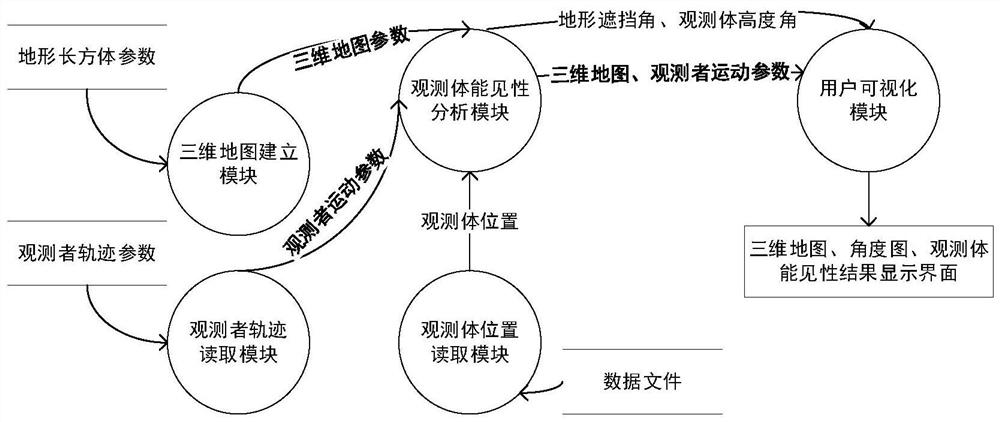
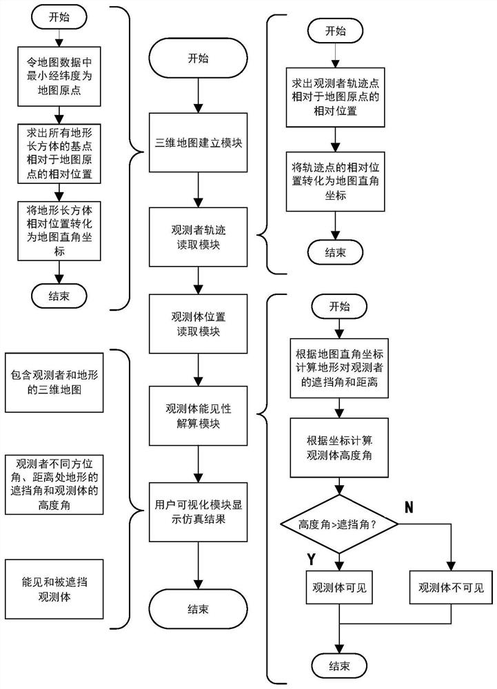
[0040] A multi-domain collaborative navigation mutual observation visibility search system proposed by the present invention includes a three-dimensional map establishment module, an observer trajectory reading module, an observation body position reading module, an observation body visibility calculation module and a user visualization module.

[0041]The three-dimensional map building module includes a map data reading unit and a coordinate conversion unit, wherein the coordinate conversion unit converts the terrain position and height parameters in the file into three-dimensional parameters used by the program in calculation. The observer trajectory reading module, th...


PUM


Abstract

The invention discloses a multi-domain collaborative navigation mutual observation visibility search system and a real-time modeling method. The method comprises the steps that terrain data in a data file is read by a three-dimensional map establishing module to establish a three-dimensional map; a position of an observation body is read by an observation body position reading module; a position of an observer is obtained by an observer track reading module; an observation body visibility resolving module calculates elevation angles of the observation body and a terrain relative to the observer based on the position of the observation body, the position of the observer and the terrain data, and resolves visibility data of the observer to the observation body; and a user visualization module displays a system operation interface and a resolving result in real time. According to the method provided by the invention, the three-dimensional map is simply and efficiently constructed, a visibility range of the moving observer to the observation body in a three-dimensional environment is calculated, and algorithm processing results such as the three-dimensional map of a position nearby the observer, the visible observation body and the observation body visibility range are displayed on a user visual interface in real time.

Description

technical field [0001] The invention relates to a multi-domain collaborative navigation mutual observation visibility search system and a real-time modeling method, belonging to the technical field of positioning and navigation. Background technique [0002] In recent years, drone technology has developed rapidly and is widely used in various fields. Among them, the problem of self-location and target positioning of UAV swarms has always been a research hotspot at home and abroad, and is widely used in daily life, aerospace and other fields. The self-localization and targeting of UAV swarms are crucial to the completion of complex tasks. [0003] However, in a complex terrain environment, positioning UAVs, satellites and other observers are the main information sources for UAV positioning. Their positioning signals are often blocked or reflected by the terrain near the signal observer, so they suffer from non-line-of-sight and Influenced by multipath effects, this will ser...

Claims


Application Information

Patent Timeline
IPC IPC(8): G06T17/05G06F16/29G01C21/00G01C21/20G01C21/24
CPCG06T17/05G06F16/29G01C21/005G01C21/20G01C21/24
Inventor 王融赵惟成熊智刘建业陈欣张慧媛刘力何辉聂庭宇芮雨
Owner NANJING UNIV OF AERONAUTICS & ASTRONAUTICS
Learn More