
Positioning method and system based on measurement report neighbor cell list

A measurement report and neighboring cell list technology, which is applied to location information-based services, wireless communications, electrical components, etc., can solve the problems of large amount of calculation, multi-server computing resources, and poor real-time performance, so as to improve positioning accuracy and save calculation The effect of high resource and positioning performance

Pending Publication Date: 2021-12-24
ZTE CORP
View PDF0 Cites 0 Cited by
  • Summary
  • Abstract
  • Description
  • Claims
  • Application Information

AI Technical Summary

Problems solved by technology

[0003] However, these three methods have obvious disadvantages: because the measurement of GPS signals has a certain power consumption, most users do not turn on the AGPS measurement switch when using mobile terminals, so this part of the data is difficult to represent the performance of all users in the network. The overall situation; triangulation is based on the measurement indicators in the measurement report, such as timing advance (TA) and reference signal received power (RSRP) in the 4G network, to estimate the distance between the terminal and the base station, and then based on the actual latitude and longitude of the base station , the terminal is positioned through geometric calculations, but the estimated distance value is not accurate enough, so the positioning error is large
In addition, the geographic location calculated by geometry is prone to arc-shaped and ray-shaped geometric calculation traces, and the rendering effect does not match the actual situation of the network. The disadvantage of fingerprint positioning is that the specific value of RSRP varies with different user terminal types and locations. Factors such as location (such as inside, indoor, and outdoor) and even weather influences fluctuate greatly, which may result in misjudgment when matching the sample library for search, resulting in large errors
On the other hand, in the training phase of the fingerprint feature sample library, all AGPS measurement report data needs to be summarized and counted by grid, and the real-time performance is also poor.
And in the positioning stage, it is necessary to calculate the fingerprint matching degree of each measurement report according to a large number of grids one by one, so the calculation amount is large, and it needs to occupy more server computing resources

Method used


Image

  • Positioning method and system based on measurement report neighbor cell list
  • Positioning method and system based on measurement report neighbor cell list
  • Positioning method and system based on measurement report neighbor cell list

Examples


Embodiment 1

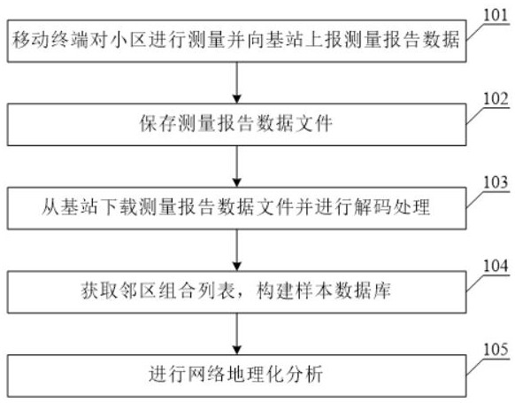
[0044] figure 1 It is a flow chart of the positioning method based on the measurement report neighbor list according to the present invention, which will be referred to below figure 1 , the method for positioning based on the neighbor cell list of the measurement report of the present invention is described in detail.

[0045] In the embodiment of the present invention, the neighbor cell relationship in the measurement report containing AGPS data is sorted by RSRP strength and then sampled to form a mapping relationship sample library of "primary cell + neighbor cell combination list -> AGPS latitude and longitude"; For the ordinary measurement report of AGPS data, the AGPS longitude and latitude in the sample library are searched according to the "combination list of main cell + adjacent cell", so as to realize the positioning calculation.

[0046] First, in step 101, the mobile terminal measures a cell and reports measurement report data to the base station.

[0047] In th...

Embodiment 2

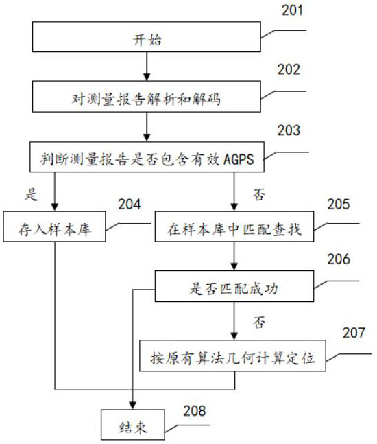
[0061] figure 2 For judging whether the measurement report according to the present invention comprises the flow chart of effective AGPS latitude and longitude information, reference will be made below figure 2 , to describe in detail the specific flow of the present invention for judging whether the measurement report contains valid AGPS latitude and longitude information.

[0062] First, in step 201, start.

[0063] In the embodiment of the present invention, the measurement report processing server downloads the measurement report file from the base station through a file transfer protocol (FTP / SFTP).

[0064] In step 202, the measurement report is parsed and decoded.

[0065] In step 203, it is determined whether the measurement report contains valid AGPS.

[0066] In the embodiment of the present invention, if it is judged that the measurement report contains valid AGPS, go to step 204; if it does not contain AGPS, go to step 205.

[0067] In step 204, store in the ...

Embodiment 3

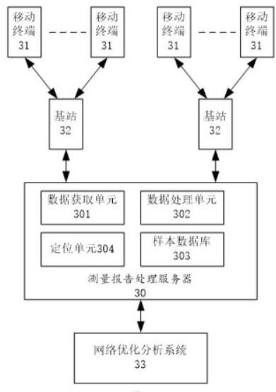
[0094] In the embodiment of the present invention, the mobile terminal measures the main cell and the adjacent cell, and reports the measurement report data to the base station, and the base station sends the received measurement report data to the measurement report processing server.

[0095] image 3 It is a schematic structural diagram of a positioning system based on a measurement report neighbor list according to the present invention, such as image 3 As shown, the positioning system based on the measurement report neighbor list of the present invention includes a measurement report processing server 30, a mobile terminal 31, a base station 32, and a network optimization analysis system 33, wherein,

[0096] The measurement report processing server 30, which obtains the measurement report data file of the mobile terminal 31 from the base station 32, and processes it, constructs a sample database with the formed adjacent cell combination list; in the sample database, sea...


PUM


Abstract

The invention discloses a positioning method based on a measurement report neighbor cell list, and the method comprises the following steps: acquiring measurement report data of a mobile terminal; performing sample data acquisition and processing on the measurement report data to obtain a neighbor cell combination list and storing the neighbor cell combination list in a sample database; and searching the latitude and longitude information of the mobile terminal in the sample database. The invention further provides a positioning system based on the measurement report neighbor cell list, so the problems that the positioning error is large and the positioning result has an obvious geometric calculation trace are solved, a long-time background training process is not needed, and a sample library can be dynamically iterated and updated in real time; moreover, the positioning calculation can be carried out only through quick search, so that the positioning performance is high, server calculation resources required by positioning are greatly saved, and the method can be competent for real-time and quick positioning of massive measurement reports.

Description

technical field [0001] The invention relates to the field of communication technology, in particular to a positioning method and system based on a neighbor cell list of a measurement report. Background technique [0002] At present, the means of network optimization is mainly through geolocation of measurement reports, and its methods mainly include satellite positioning, triangulation calculation and fingerprint feature positioning. [0003] However, these three methods have obvious disadvantages: because the measurement of GPS signals has a certain power consumption, most users do not turn on the AGPS measurement switch when using mobile terminals, so this part of the data is difficult to represent the performance of all users in the network. The overall situation; triangulation is based on the measurement indicators in the measurement report, such as timing advance (TA) and reference signal received power (RSRP) in the 4G network, to estimate the distance between the term...

Claims


Application Information

Patent Timeline
IPC IPC(8): H04W64/00H04W24/10
CPCH04W64/006H04W24/10H04W64/00H04L43/04H04W24/02G01S5/02521G01S19/06G01S5/0036
Inventor 苏梦
Owner ZTE CORP
Learn More