Large-area high-fidelity satellite remote sensing image uniform-color mosaic processing method and device

A satellite remote sensing image and processing method technology, applied in the field of surveying and mapping science, can solve problems such as large color differences, lack of fixed solutions and processes, satellite data source color uniformity and complex mosaic work, etc., to achieve good results

Active Publication Date: 2022-01-11
自然资源部国土卫星遥感应用中心
View PDF19 Cites 2 Cited by
  • Summary
  • Abstract
  • Description
  • Claims
  • Application Information

AI Technical Summary

Problems solved by technology

[0004] In view of this, the present invention provides a large-area high-fidelity satellite remote sensing image uniform color mosaic processing method, which solves the color difference between images imaged at different times in the same area due to different satellite image imaging conditions, time and atmospheric environment in the prior art The large size, coupled with the differences between different sensors, makes the color uniformity and mosaic work of multiple satellite data sources very complicated, and there is a lack of effective fixed solutions and technical problems of the process

Method used


Image

  • Large-area high-fidelity satellite remote sensing image uniform-color mosaic processing method and device
  • Large-area high-fidelity satellite remote sensing image uniform-color mosaic processing method and device
  • Large-area high-fidelity satellite remote sensing image uniform-color mosaic processing method and device

Examples


Embodiment 1

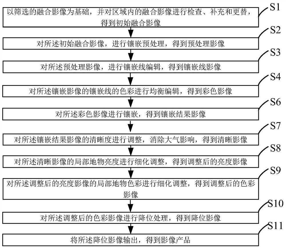
[0095] figure 1 A schematic flow diagram of a large-area high-fidelity satellite remote sensing image uniform color mosaic processing method provided by the embodiment of the present invention; figure 1 As shown, a large-area high-fidelity satellite remote sensing image uniform color mosaic processing method, the method includes:

[0096] S1: Based on the selected fusion image, check, supplement and replace the fusion image in the area to obtain the initial fusion image;

[0097] S2: Perform mosaic preprocessing on the initial fused image to obtain a preprocessed image;

[0098] S3: Perform mosaic line editing on the preprocessed image to obtain a mosaic line image;

[0099] S4: Perform balanced editing on the color of the mosaic lines of the mosaic image to obtain a color image;

[0100] S6: Mosaicking the color image to obtain a mosaic result image;

[0101] S7: Adjust the definition of the mosaic result image, eliminate the influence of the atmosphere, and obtain a clea...

Embodiment 2

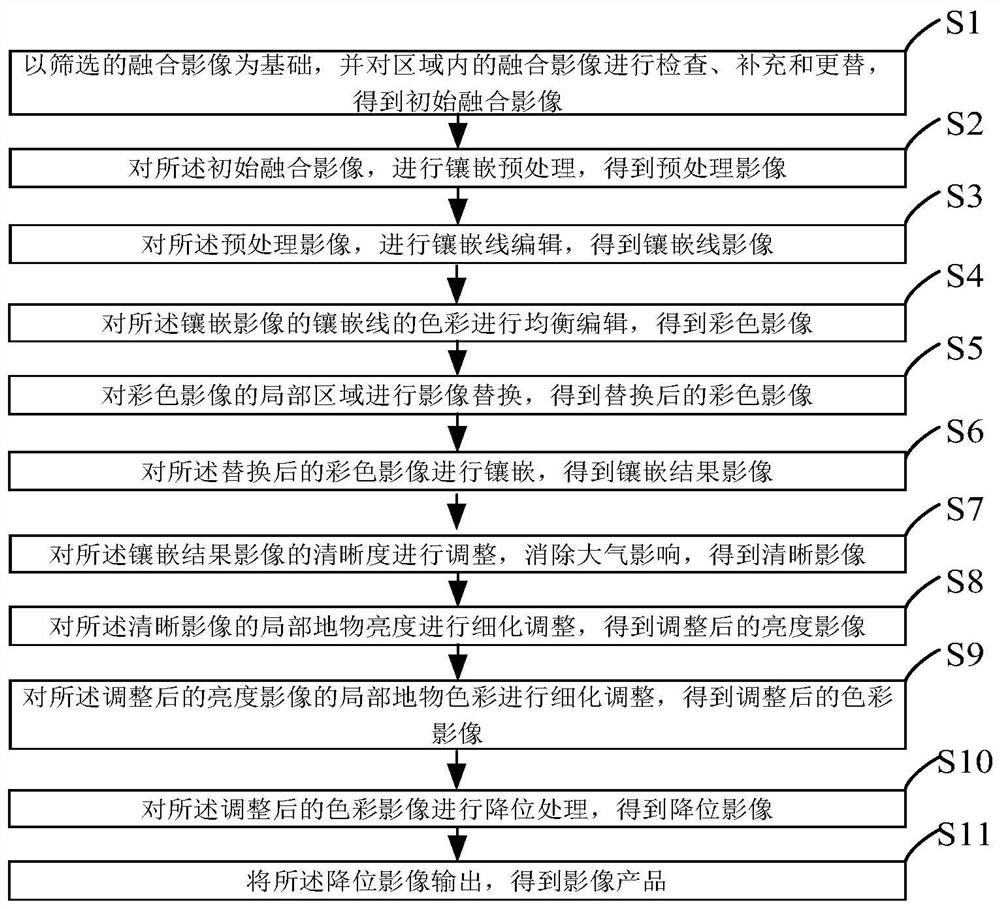
[0143] According to the method in embodiment 1, in some embodiments, such as figure 2 As shown, on the basis of the method in Example 1, between the S4 step and the S6 step, step S5 is selectively added, specifically:

[0144] S5: performing image replacement on a local area of ​​the color image;

[0145] S51: Modify and / or replace the local area of ​​the color image after the color balance to achieve an overall mosaic effect.

[0146] The step S5 is practical and operable for data selection and replacement of multiple overlapping images in the region. For images in two-degree overlapping areas, you only need to edit mosaic lines in the overlapping area, but for images with multiple degrees of overlap, the selection and editing of mosaic lines will be very complicated. Therefore, this method is based on the above-mentioned single scene results and mosaic results after color equalization, and on this basis, the local area is modified and edited to achieve the overall mosaic ...

Embodiment 3

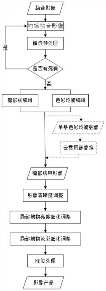
[0148] According to specific embodiments and actual operations, this embodiment provides a large-area high-fidelity satellite remote sensing image uniform color mosaic processing method, such as image 3 As shown, the details are as follows:

[0149] S1: Based on the selected fusion image, check, supplement and replace the fusion image in the area to obtain the initial fusion image:

[0150] Image screening: start with single-view panchromatic and multi-spectral orthorectified true-color fusion images to filter images. Check the overall data coverage and image quality of the operation area, understand the types of regional features, determine the areas that need to be supplemented and replaced with images, and then complete the image replacement. This step needs to consider four aspects: the effective data coverage ratio of the operation area, the size of the hole area; the coverage ratio of the cloud and snow area; the seasonal difference of adjacent images; the size of the ...


PUM


Abstract

The invention provides a large-area high-fidelity satellite remote sensing image uniform-color mosaic processing method and device, and the method comprises the following steps: screening a fusion image, and carrying out inspection, supplement and replacement of the fusion image; carrying out mosaic preprocessing on the initial fusion image, carrying out mosaic line editing on the preprocessed image, carrying out balanced editing on the color of a mosaic line, carrying out mosaic, adjusting the definition of the image, eliminating the atmospheric influence, carrying out refined adjustment on the local surface feature brightness and color of the image, and carrying out bit reduction processing on the image; and outputting to obtain an image product. The method solves the problems that in the prior art, due to the difference of satellite image imaging conditions, time and atmospheric environments, the color difference between images imaged at different time in the same area is large, and due to the difference between different sensors, the color uniformizing and embedding work of multiple satellite data sources becomes very complex, and the data quality is poor. And there is no effective fixed solution method and process.

Description

technical field [0001] The present invention relates to the field of surveying and mapping science and technology, and in particular to a large-area high-fidelity satellite remote sensing image uniform color mosaic processing method and device. Background technique [0002] Due to the different imaging conditions, time and atmospheric environment of satellite images, the color difference between the images imaged at different times in the same area is large, and the difference between different sensors makes the color uniformity and mosaic work of various satellite data sources very difficult. Complicated, lacking effective fixed solutions and processes. [0003] From the perspective of satellite imagery characteristics, the main problems that affect the color uniformity and mosaic processing of satellite images are: the difference of satellite sensors, the difference of radiation resolution of satellite images, the difference of satellite images in different time phases, th...

Claims


Application Information

Patent Timeline
Patent Type & Authority Applications(China)
IPC IPC(8): G06T5/00G06T7/62
CPCG06T5/008G06T7/62G06T2207/20221G06T2207/10024G06T2207/10032
Inventor 李鸿洲刘书含薛白何昭宁王艺颖王霞郭莉
Owner 自然资源部国土卫星遥感应用中心
Why Eureka
Try Eureka