Positioning method combining airport runway vision and GNSS/inertial navigation

An airport runway and positioning method technology, which is applied in mapping and navigation, navigation and navigation through speed/acceleration measurement, can solve problems such as unfavorable accurate control of aircraft landing, and achieve high-precision positioning and improve positioning accuracy.

Pending Publication Date: 2022-01-14
四川腾盾科技有限公司
View PDF0 Cites 2 Cited by
  • Summary
  • Abstract
  • Description
  • Claims
  • Application Information

AI Technical Summary

Problems solved by technology

After the visual analysis and processing unit acquires the video information collected by the front-view camera, it takes a certain amount of time to recognize the image, that is, when the high-level information of the airport is calculated through image recognition, the aircraft is no longer in its original position, and there is a delay in visual ...

Method used


Image

  • Positioning method combining airport runway vision and GNSS/inertial navigation

Examples


Embodiment Construction

[0027] All features disclosed in all embodiments in this specification, or steps in all implicitly disclosed methods or processes, except for mutually exclusive features and / or steps, can be combined and / or extended and replaced in any way.

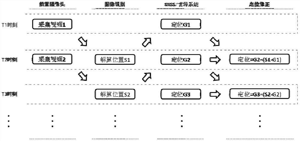
[0028] Such as figure 1 As shown, a positioning method combining airport runway vision and GNSS / inertial navigation includes the steps of: adopting the difference between historical moment visual positioning and GNSS / inertial navigation positioning to correct the current moment GNSS / inertial navigation positioning Improve positioning accuracy.

[0029] In an optional embodiment, substeps are included:

[0030] S1, acquire camera parameters, as the input of the visual analysis and processing unit, the camera parameters include the camera internal parameter matrix of the relationship between the camera coordinate system and the aircraft coordinate system, the relationship between the object coordinates and the screen coordinates after imag...


PUM


Abstract

The invention discloses an airport runway vision and GNSS/inertial navigation combined positioning method. The method comprises a step of correcting GNSS/inertial navigation combined navigation positioning at the current moment by adopting the difference between vision positioning at the historical moment and GNSS/inertial navigation combined navigation positioning so as to improve positioning precision. According to the method, positioning precision is improved, and the method has no special requirement on the airport, and has important significance in improving adaptability of an aircraft to the airport and increasing the application area and application scene of the aircraft.

Description

technical field [0001] The invention relates to the technical field of aircraft navigation and positioning, and more specifically, relates to a positioning method combining airport runway vision and GNSS / inertial navigation. Background technique [0002] During the landing phase of the aircraft, precise glide trajectory control is required to ensure that the landing point is in a suitable area, which is crucial to the safety of the aircraft's takeoff and landing. If the landing point is too early, the descent height is too fast before entering the runway, and there is a risk of encountering obstacles; if the landing point is too late, the length of the runway will be underutilized, and there is a risk of running out of the runway. When taking off and landing, it is also necessary to keep the aircraft near the centerline of the runway. If it deviates too far, there is a risk of sliding off the runway from the side. [0003] For manned aircraft, the judgment of the position r...

Claims


Application Information

Patent Timeline
IPC IPC(8): G01C21/16G01C21/20
CPCG01C21/165G01C21/1656G01C21/20
Inventor 彭钧刘庆航刘可尹晓辉王林涛王健存
Owner 四川腾盾科技有限公司
Why Eureka
Try Eureka