Accumulated snow depth inversion method based on multi-satellite data fusion

A technology of snow depth and data fusion, which is applied in the field of snow depth inversion based on multi-satellite data fusion, which can solve the problems of affecting satellites, difficult to accurately reflect the snow depth information of stations, and reducing the reliability and accuracy of satellite inversion. , to achieve the effect of improving reliability and accuracy

Inactive Publication Date: 2022-01-21
SOUTHWEST JIAOTONG UNIV
View PDF1 Cites 1 Cited by
  • Summary
  • Abstract
  • Description
  • Claims
  • Application Information

AI Technical Summary

Problems solved by technology

However, the surrounding environment of the station and the differences of the satellite itself will affect the results of

Method used


Image

  • Accumulated snow depth inversion method based on multi-satellite data fusion
  • Accumulated snow depth inversion method based on multi-satellite data fusion
  • Accumulated snow depth inversion method based on multi-satellite data fusion

Examples


Embodiment Construction

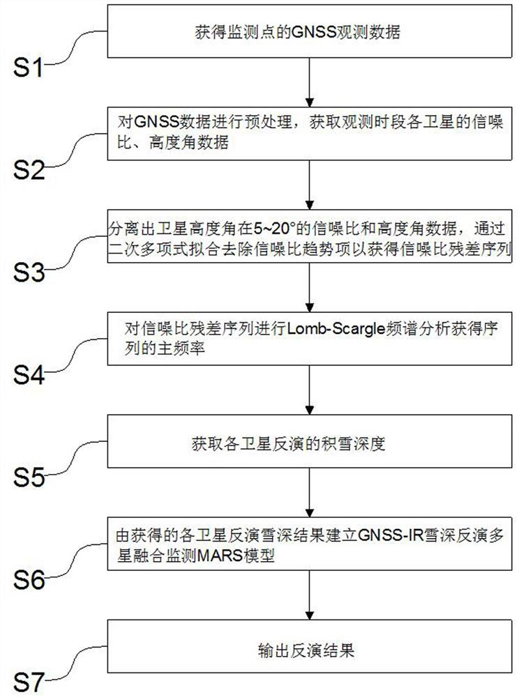
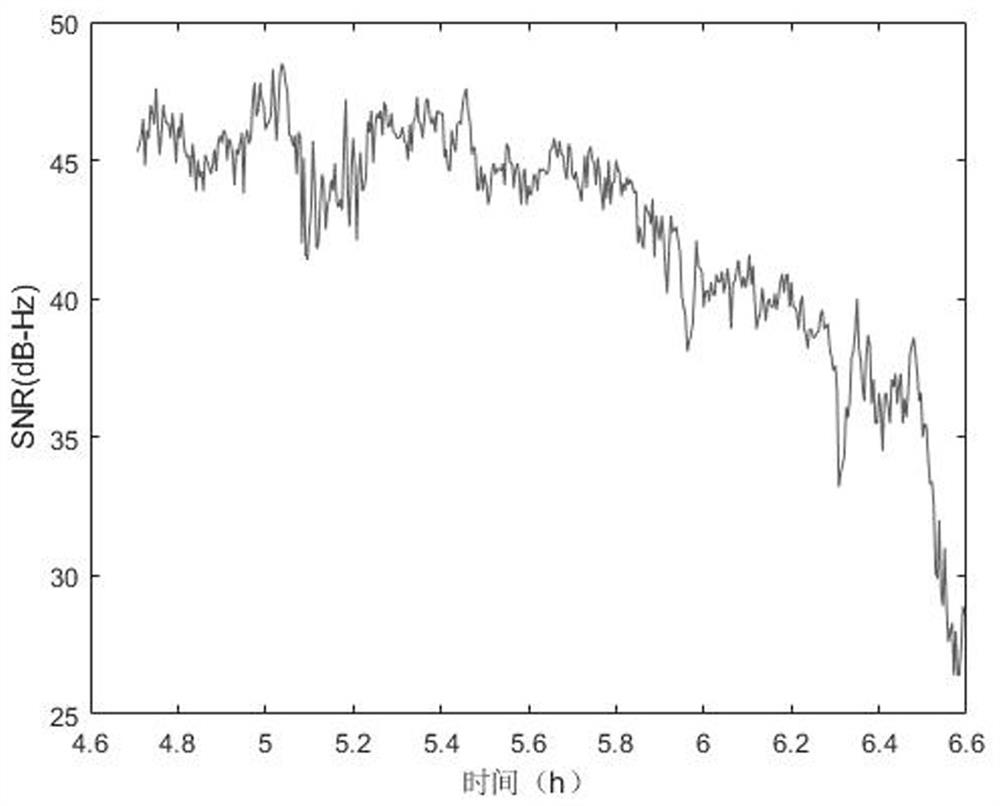
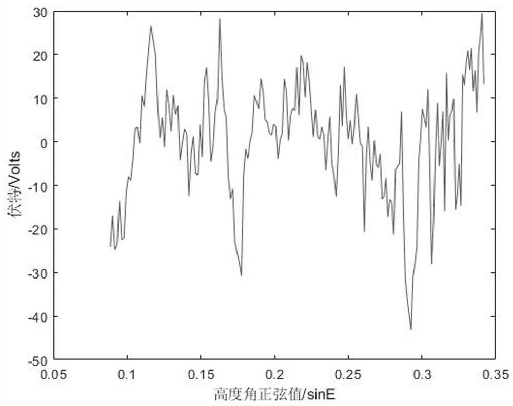
[0045] In order to make the purpose, technical solutions and advantages of the embodiments of the present invention more clear, the technical solutions in the embodiments of the present invention will be clearly and completely described below in conjunction with the drawings in the embodiments of the present invention. Apparently, the described embodiments are some, but not all, embodiments of the present invention. The components of the embodiments of the invention generally described and illustrated in the figures herein may be arranged and designed in a variety of different configurations.

[0046] Accordingly, the following detailed description of the embodiments of the invention provided in the accompanying drawings is not intended to limit the scope of the claimed invention, but merely represents selected embodiments of the invention. Based on the embodiments of the present invention, all other embodiments obtained by persons of ordinary skill in the art without creative...


PUM


Abstract

The invention relates to the technical field of accumulated snow depth monitoring, in particular to an accumulated snow depth inversion method based on multi-satellite data fusion, which comprises the following steps: acquiring GNSS observation data of a monitoring point; preprocessing the GNSS data, and acquiring the signal-to-noise ratio and elevation angle data of each satellite in the observation time period; separating signal-to-noise ratio and elevation angle data of a satellite elevation angle of 5-20 degrees, and removing a signal-to-noise ratio trend term through quadratic polynomial fitting to obtain a signal-to-noise ratio residual error sequence; carrying out lomb-Scargle spectrum analysis on the signal-to-noise ratio residual error sequence to obtain the main frequency of the sequence; acquiring the snow depth inverted by each satellite; establishing a GNSS-IR snow depth inversion multi-satellite fusion monitoring MARS model according to the obtained inversion snow depth result of each satellite; and outputting an inversion result. According to the method, the multi-satellite data fusion accumulated snow inversion model is established through the MARS theory, the inversion results of all satellites can be effectively integrated, data having great influence on the results are automatically eliminated, the optimal inversion satellite combination is obtained, and the reliability and precision of the inversion results are greatly improved.

Description

technical field [0001] The invention relates to the technical field of snow depth monitoring, in particular to a snow depth retrieval method based on multi-satellite data fusion. Background technique [0002] Snow cover is an important part of the hydrological system, which plays an important role in the balance of freshwater resources and the regulation of climate. Therefore, it is of great significance to continuously and accurately monitor the change of ground snow depth. The traditional snow cover monitoring methods mainly rely on manual measurement or automatic machine measurement on the ground, but these traditional methods have disadvantages such as large field workload, high cost of monitoring equipment, and low temporal and spatial resolution. [0003] With the in-depth study of the global navigation and positioning system, GNSS-IR (Global Navigation Satellite System Interferometric Reflectometry) technology has gradually developed as a new remote sensing monitorin...

Claims


Application Information

Patent Timeline
IPC IPC(8): G01B7/26G01S19/14
CPCG01B7/26G01S19/14
Inventor 张瑞詹君玉吕继超沙马阿各涂晋升王晓文张伦宁
Owner SOUTHWEST JIAOTONG UNIV
Why Eureka
Try Eureka