
Satellite infrared load calibration method based on ocean region reanalysis data

A reanalysis and satellite technology, applied in the field of remote sensing, can solve problems such as long calibration period, high calibration frequency, and affect calibration accuracy, and achieve low cost data acquisition, increase calibration frequency, and easy data acquisition

Pending Publication Date: 2022-01-25
AEROSPACE INFORMATION RES INST CAS
View PDF3 Cites 4 Cited by
  • Summary
  • Abstract
  • Description
  • Claims
  • Application Information

AI Technical Summary

Problems solved by technology

The on-board calibration method is not affected by objective factors such as time and environment, and can obtain sensor calibration coefficients in real time. However, the on-board calibration system is affected by outer space radiation, and its performance may decay over time, affecting calibration accuracy.
Site calibration can use the measured surface and atmospheric parameters to provide accurate absolute radiation calibration coefficients, but this method is easily limited by geographical space, and requires simultaneous observations when satellites transit, which consumes a lot of manpower and material resources, and the calibration cost is high , which also leads to relatively long calibration period and low frequency
The cost of cross-calibration is low, and absolute radiometric calibration can be realized without establishing a ground correction field. However, the calibration accuracy of this method depends on the observation accuracy of the reference sensor itself. The number of calibrations is relatively small, and a high calibration frequency cannot be achieved

Method used


Image

  • Satellite infrared load calibration method based on ocean region reanalysis data
  • Satellite infrared load calibration method based on ocean region reanalysis data
  • Satellite infrared load calibration method based on ocean region reanalysis data

Examples


Embodiment Construction

[0046] In order to enable those skilled in the art to better understand the solutions of the present application, the technical solutions in the embodiments of the present application will be clearly and completely described below in conjunction with the drawings in the embodiments of the present application.

[0047] The purpose of the present invention is to provide a satellite infrared load calibration method based on reanalysis data in ocean areas, which uses reanalysis data, low cost and can realize high frequency and high precision infrared spectrum radiometric calibration, and at the same time This method can carry out long-term absolute radiometric calibration under a unified calibration reference for the historical observation data of sensor infrared load.

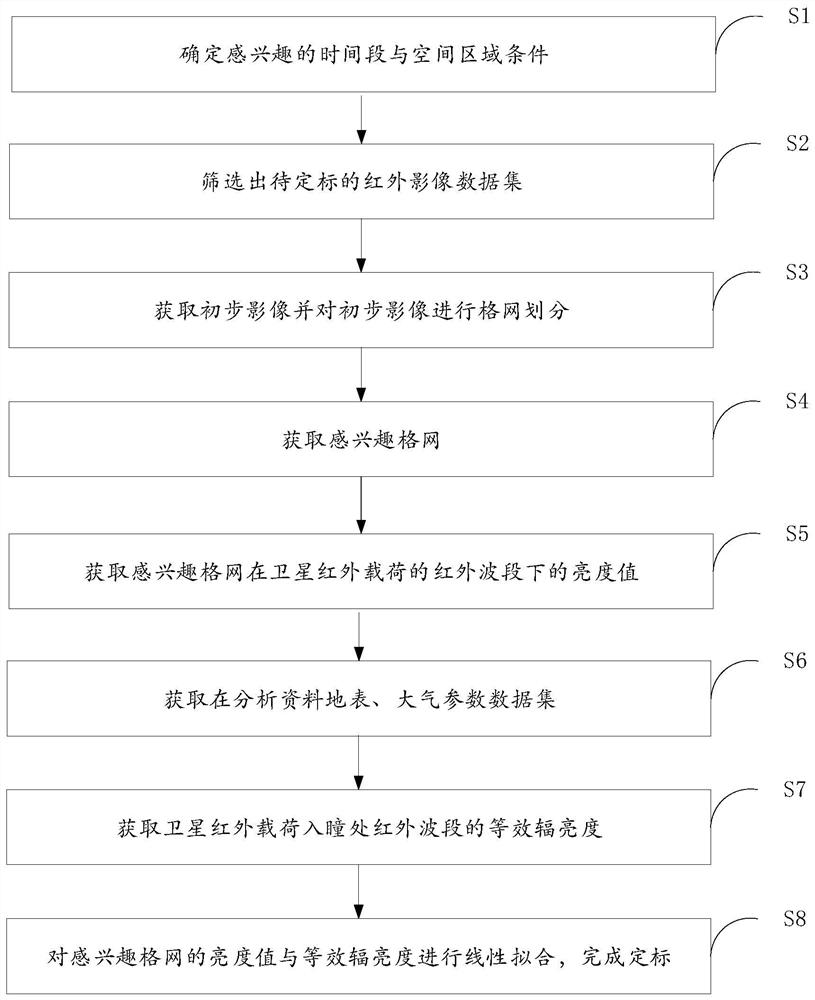
[0048] Specifically, such as figure 1 As shown, a satellite infrared payload calibration method based on ocean area reanalysis data includes the following steps:

[0049] S1: Determine the time period and space a...


PUM


Abstract

The invention provides a satellite infrared load calibration method based on ocean region reanalysis data, and the method comprises the steps: obtaining the latitude and longitude information of an interested grid corresponding to a cloudless and uniform interested sea area according to a screened and extracted infrared load image data set to be calibrated, and carrying out the preprocessing of spatial interpolation and time aggregation based on the extracted reanalysis data; calculating satellite observation entrance pupil equivalent radiance by utilizing an atmospheric radiation transmission model and combining reanalysis of sea surface, atmospheric parameters and satellite observation auxiliary information, and calculating a calibration coefficient by linear fitting satellite observation entrance pupil equivalent radiance with a brightness value of the interested grid, so as to realize absolute radiation calibration. Therefore, the reanalysis data is used as the radiometric calibration reference source, field earth surface and atmosphere parameter measurement work does not need to be carried out, data acquisition is easy and convenient, the cost is low, meanwhile, radiometric calibration work is carried out based on the cloudless and uniform sea surface, the calibration frequency can be effectively improved, and meanwhile the calibration precision can be guaranteed.

Description

technical field [0001] The invention belongs to the technical field of remote sensing, in particular to a method for calibrating satellite infrared loads based on ocean area reanalysis data. Background technique [0002] Absolute radiometric calibration of satellite payload sensors is the premise and key to the quantitative application of remote sensing data. After radiometric calibration, remote sensing data can reflect the characteristics and changing laws of ground objects. Absolute radiometric calibration refers to the process of establishing a quantitative relationship between the luminance value of the image pixel observed by the sensor and the apparent radiance at the entrance pupil. After the satellite is launched into the sky, due to the outer space radiation and the aging of components, the observation performance of the instrument may change, affecting the authenticity and accuracy of remote sensing data. Therefore, it is necessary to carry out on-orbit absolute r...

Claims


Application Information

Patent Timeline
Patent Type & Authority Applications(China)
IPC IPC(8): G01J5/53
CPCG01J2005/0077Y02A90/10
Inventor 王宁薛亚楠李坤马灵玲王新鸿钱永刚李传荣唐伶俐
Owner AEROSPACE INFORMATION RES INST CAS
Learn More