
Thunderstorm and gale early warning method and system, equipment and terminal

A technology for strong winds and thunderstorms, applied in the field of nowcasting and early warning, can solve the problems of thunderstorm and strong wind early warning lag, convective strong wind enhancement characteristics cannot be predicted early warning, and spatial distribution is uneven.

Active Publication Date: 2022-02-08
浙江省气象台
View PDF7 Cites 6 Cited by
  • Summary
  • Abstract
  • Description
  • Claims
  • Application Information

AI Technical Summary

Problems solved by technology

[0007] (1) In terms of radar detection and early warning, the zero-degree bright band is one of the characteristics of continuous precipitation. In stratiform cloud precipitation, affected by the zero-degree bright band, it may cause certain pollution to the early warning; in terms of model forecasting, The index forecasts are only for potential analysis and general trend forecasting, which can only be used as a reference for forecasting and early warning, not as early warning indicators
[0008] (2) In terms of ground observation automatic stations, there are problems of uneven spatial distribution and low resolution. The deployment of automatic stations in mountainous areas and other places is rare and there are observation blind spots, and there is a lag in time. Generally, the return data of automatic stations lags behind by 7 Minutes, then there is a lag between the occurrence of severe weather in the air and the observation of the phenomenon on the ground
[0009] (3) In the existing thunderstorm and strong wind warning technology, the radar short-term extrapolation is extrapolated according to the echo intensity unchanged, and it is impossible to predict the local convective cell strength enhancement, and the convective strong wind enhancement characteristics cannot be predicted.
[0010] (4) Automatic stations have observed the characteristics of strong winds on the ground, and disasters have usually occurred. Therefore, there is a lag problem in the warning of thunderstorms and strong winds based on automatic stations, and it is necessary to rely on radar and lightning data to distinguish between coastal systemic strong winds and thunderstorms.
[0011] (5) The numerical model lacks the prediction products of thunderstorms and strong winds, so it is impossible to carry out direct early warning of thunderstorms and strong winds; on the dual-polarization business radar, since both are based on the direct inversion products of Doppler radial velocity, the radial velocity Clutter or noise information will lead to the generation of wrong inversion information

Method used


Image

  • Thunderstorm and gale early warning method and system, equipment and terminal
  • Thunderstorm and gale early warning method and system, equipment and terminal
  • Thunderstorm and gale early warning method and system, equipment and terminal

Examples


Embodiment Construction

[0074] In order to make the object, technical solution and advantages of the present invention clearer, the present invention will be further described in detail below in conjunction with the examples. It should be understood that the specific embodiments described here are only used to explain the present invention, not to limit the present invention.

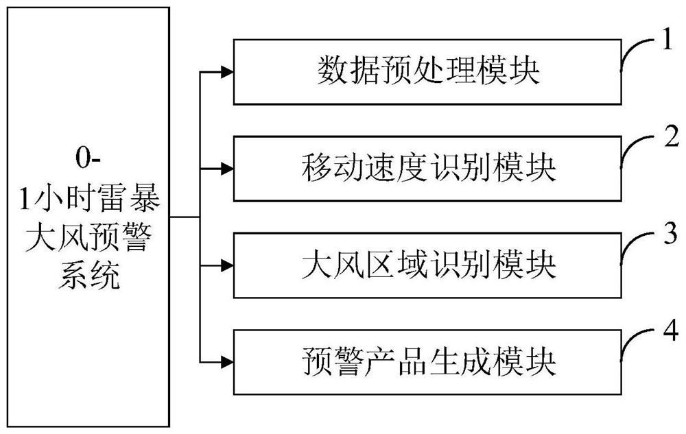
[0075] Aiming at the problems existing in the prior art, the present invention provides a 0-1 hour thunderstorm and strong wind early warning method, system, equipment and terminal. The present invention will be described in detail below in conjunction with the accompanying drawings.

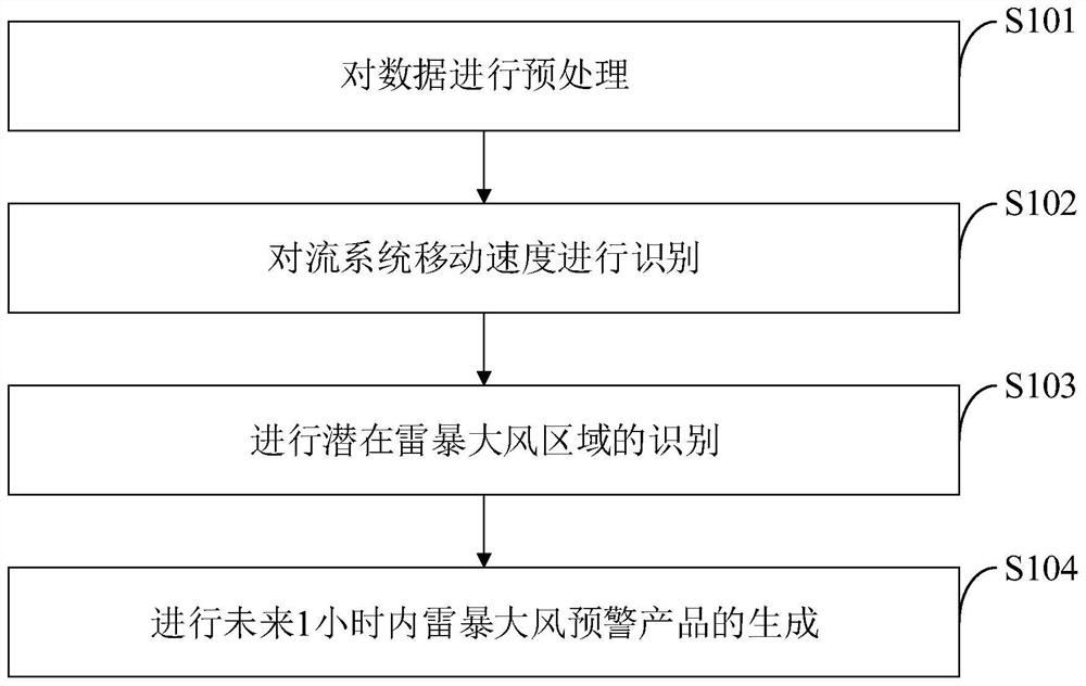
[0076] Such as figure 1 As shown, the 0-1 hour thunderstorm gale early warning method that the embodiment of the present invention provides comprises the following steps:

[0077] S101, preprocessing the data;

[0078] S102, identifying the moving speed of the convection system;

[0079] S103, identifying a potential thunderstorm and strong w...


PUM


Abstract

The invention belongs to the technical field of nowcasting and early warning, and discloses a thunderstorm and gale early warning method and system, equipment and a terminal. The method comprises the steps of: preprocessing single radar data, and recognizing a potential thunderstorm and gale region; combining ground thunderstorm and gale information observed by an automatic station to establish a potential thunderstorm and gale area identification model and a thunderstorm and gale parameter inversion model; applying the models to a real-time thunderstorm and gale early warning service; and in the real-time service, within the single-radar identification potential thunderstorm and gale area at each time, carrying out one-hour extrapolation by calling a thunderstorm and gale parameter model, and then forming a thunderstorm and gale early warning product in the future one hour. According to the thunderstorm and gale early warning method, the identification technology of the dual-polarization radar is fully utilized, potential identification is carried out on the thunderstorm gale, the falling area of the potential thunderstorm gale in the next one hour is obtained through the extrapolation technology, and compared with an existing thunderstorm gale early warning method, the method has better advance and accuracy.

Description

technical field [0001] The invention belongs to the technical field of nowcasting and early warning, and in particular relates to a 0-1 hour thunderstorm and strong wind early warning method, system, equipment and terminal. Background technique [0002] At present, the nowcasting and early warning technology was developed on the basis of radar extrapolation in the 1960s and 1970s. In recent years, the research on the nowcasting and early warning technology of severe convective weather based on radar data has emerged in an endless stream. At the same time, many scholars have combined conventional ground detection data, radiosonde data, lightning data, satellite data, and mesoscale numerical model data with radar data. It is used to improve the temporal and spatial accuracy of nowcasting and early warning. A large number of scholars have shown that radar indicators are indicative of early warning of short-term heavy precipitation. Feng Jinqin used the new generation of weath...

Claims


Application Information

Patent Timeline
IPC IPC(8): G01S13/95G01W1/10
CPCG01S13/95G01W1/10Y02A90/10G01S13/951G01W2203/00
Inventor 黄旋旋冯爽张磊苏桂炀罗然张智察李文娟黄娟陈列娄小芬罗玲
Owner 浙江省气象台
Learn More