Eureka AIR delivers breakthrough ideas for toughest innovation challenges, trusted by R&D personnel around the world.

Urban monocular mapping method and system based on GPS constraint and dynamic correction

A dynamic correction and visual map technology, applied in the field of urban monocular map methods and systems, can solve problems such as difficult and stable acquisition, and achieve the effects of reducing dependence, increasing reliability, and reducing requirements

Pending Publication Date: 2022-02-08
WUHAN ZHONGHAITING DATA TECH CO LTD
View PDF0 Cites 0 Cited by
  • Summary
  • Abstract
  • Description
  • Claims
  • Application Information

AI Technical Summary

Problems solved by technology

However, the fusion of GPS and monocular camera for measurement Figure 1 Generally, it is necessary to accurately calibrate the sensor in advance, including the internal parameters of the camera and the external parameters from the camera to GPS, time delay and other parameters. In addition, due to the long-term driving bumps of the vehicle, these key parameters will also change dynamically over time. These require the laboratory The key parameters calibrated in the environment are difficult to obtain stably in natural scenes. In addition, the scale drift of the monocular camera mapping itself also increases the practical difficulties of cameras and consumer-grade GPS equipment used in urban road environment mapping.
[0004] The current method of solving monocular camera mapping is difficult to take into account the requirements of automation, accuracy and reliability at the same time, and the advantages of low cost, simple deployment and wide application of monocular camera make it an ideal choice for crowdsourcing mapping. Bicycle mapping with cameras and consumer-grade GPS devices is the basis for crowdsourced mapping with vision as the core. However, the difficulty of calibrating cameras and GPS devices in urban environments and the scale drift of monocular maps have negative impacts on crowdsourced mapping. Accuracy and reliability pose major challenges

Method used


Image

  • Urban monocular mapping method and system based on GPS constraint and dynamic correction
  • Urban monocular mapping method and system based on GPS constraint and dynamic correction
  • Urban monocular mapping method and system based on GPS constraint and dynamic correction

Examples


Embodiment 1

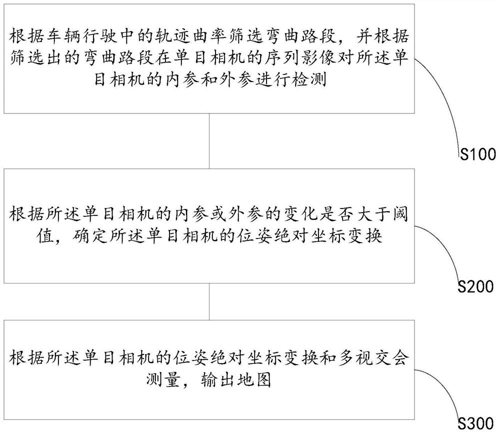
[0030] refer to figure 1 and image 3, in the first aspect of the present invention, a method for monocular mapping of urban areas based on GPS constraints and dynamic corrections is provided, including: S100. Screening curved road sections according to the curvature of the vehicle's trajectory, and according to the screened curved road sections in the monocular The sequence image of the camera detects the internal reference and external reference of the monocular camera; S200. According to whether the change of the internal reference or external reference of the monocular camera is greater than a threshold, determine the absolute coordinate transformation of the pose of the monocular camera; S300. Output a map according to the absolute coordinate transformation of the monocular camera's pose and the intersecting measurement.

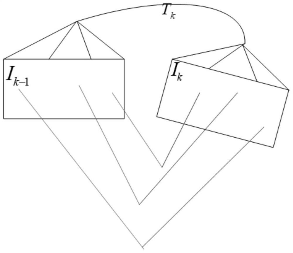
[0031] It can be understood that the internal reference or external reference in the present invention usually exists in the form of a tuple or a mat...

Embodiment 2

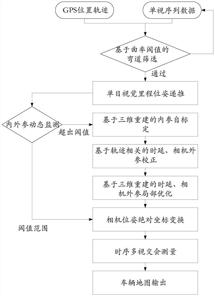
[0052] refer to Figure 4 , the second aspect of the present invention provides an urban monocular mapping system 1 based on GPS constraints and dynamic correction, including a detection module 11, a determination module 12 and an output module 13, the detection module 11 is used to The trajectory curvature in the filter screens the curved road section, and detects the internal reference and external reference of the monocular camera according to the sequence image of the screened curved road section in the monocular camera;

[0053] The determination module 12 is used to determine the absolute coordinate transformation of the monocular camera's pose according to whether the change of the internal or external parameters of the monocular camera is greater than a threshold; the output module 13 is used to determine the absolute coordinate transformation of the monocular camera according to the The absolute coordinate transformation of the camera's pose and multi-view intersectio...

Embodiment 3

[0057] A third aspect of the present invention provides an electronic device, including: one or more processors; a storage device for storing one or more programs, when the one or more programs are used by the one or more The processor executes, so that the one or more processors implement the urban monocular mapping method based on GPS constraints and dynamic correction provided by the first aspect of the present invention.

[0058] refer to Figure 5 , the urban monocular mapping device 500 based on GPS constraints and dynamic correction may include a processing device (such as a central processing unit, a graphics processing unit, etc.) 508 programs loaded into random access memory (RAM) 503 to execute various appropriate actions and processes. In the RAM 503, various programs and data necessary for the operation of the electronic device 500 are also stored. The processing device 501 , ROM 502 and RAM 503 are connected to each other through a bus 504 . An input / output (I...


PUM


Abstract

The invention relates to an urban monocular mapping method and system based on GPS constraint and dynamic correction, and the method comprises the steps: screening a curved road section according to the trajectory curvature of a vehicle during driving, and detecting the internal and external parameters of a monocular camera according to the sequence image of the screened curved road section in the monocular camera; determining pose absolute coordinate transformation of the monocular camera according to whether the change of the internal reference or the external reference of the monocular camera is greater than a threshold value or not; and outputting a map according to the pose absolute coordinate transformation and the multi-view intersection measurement of the monocular camera. According to the invention, the monocular camera and the consumer-level GPS equipment are fused for single-vehicle mapping, so that the dependence on a laboratory calibration environment is reduced, and the mapping reliability is improved.

Description

technical field [0001] The invention belongs to the field of automatic driving navigation and high-precision maps, and relates to a monocular mapping method and system, in particular to a monocular mapping method and system for urban areas based on GPS constraints and dynamic correction. Background technique [0002] In related fields such as automatic driving navigation and high-precision maps, in order to implement safe route planning and navigation decisions, three-dimensional geometric information of the road environment around the vehicle is required. Currently, map dealers need professional acquisition vehicles to collect and produce corresponding road environment maps, including lasers. Radar, binocular cameras, high-precision inertial navigation, wheel speed information, millimeter-wave radar and other professional equipment generally have relatively high acquisition costs. Due to the frequent construction and maintenance of the urban road environment, the road eleme...

Claims


Application Information

Patent Timeline
Patent Type & Authority Applications(China)
IPC IPC(8): G06T7/80G06V10/44G06V20/40
CPCG06T7/80G06T2207/10016Y02T10/40
Inventor 尹玉成
Owner WUHAN ZHONGHAITING DATA TECH CO LTD
Why Eureka
Eureka Blog
Learn More