Remote sensing inversion method and system for water meter salinity of estuary region based on satellite-ground collaboration,

A remote sensing inversion and salinity technology, applied in the field of water environment monitoring, can solve the problems of poor universality and strong experience, and achieve the effect of improving the inversion accuracy

Inactive Publication Date: 2022-02-11
PEARL RIVER HYDRAULIC RES INST OF PEARL RIVER WATER RESOURCES COMMISSION
View PDF8 Cites 0 Cited by
  • Summary
  • Abstract
  • Description
  • Claims
  • Application Information

AI Technical Summary

Problems solved by technology

[0006] The purpose of the present invention is to overcome the problems of strong experience and poor universality of the above-mentioned water surface salinity retrieval model based on optical remote sensing, and propose a remote sensing retrieval method of water surface salinity in the estuary area based on satellite-ground coordination. The relatively high ground measured data in the estuary area improves the inversion accuracy of the remote sensing inversion model; on the other hand, the traditional remote sensing inversion model is improved to invert the water surface salinity only through spectral information or indirect water quality parameters, and the geographic grid information is added. As an input parameter, it makes full use of the spatially continuous data characteristics of remote sensing images to achieve high-precision inversion of water surface salinity in the estuary area

Method used


Image

  • Remote sensing inversion method and system for water meter salinity of estuary region based on satellite-ground collaboration,
  • Remote sensing inversion method and system for water meter salinity of estuary region based on satellite-ground collaboration,
  • Remote sensing inversion method and system for water meter salinity of estuary region based on satellite-ground collaboration,

Examples


Embodiment 1

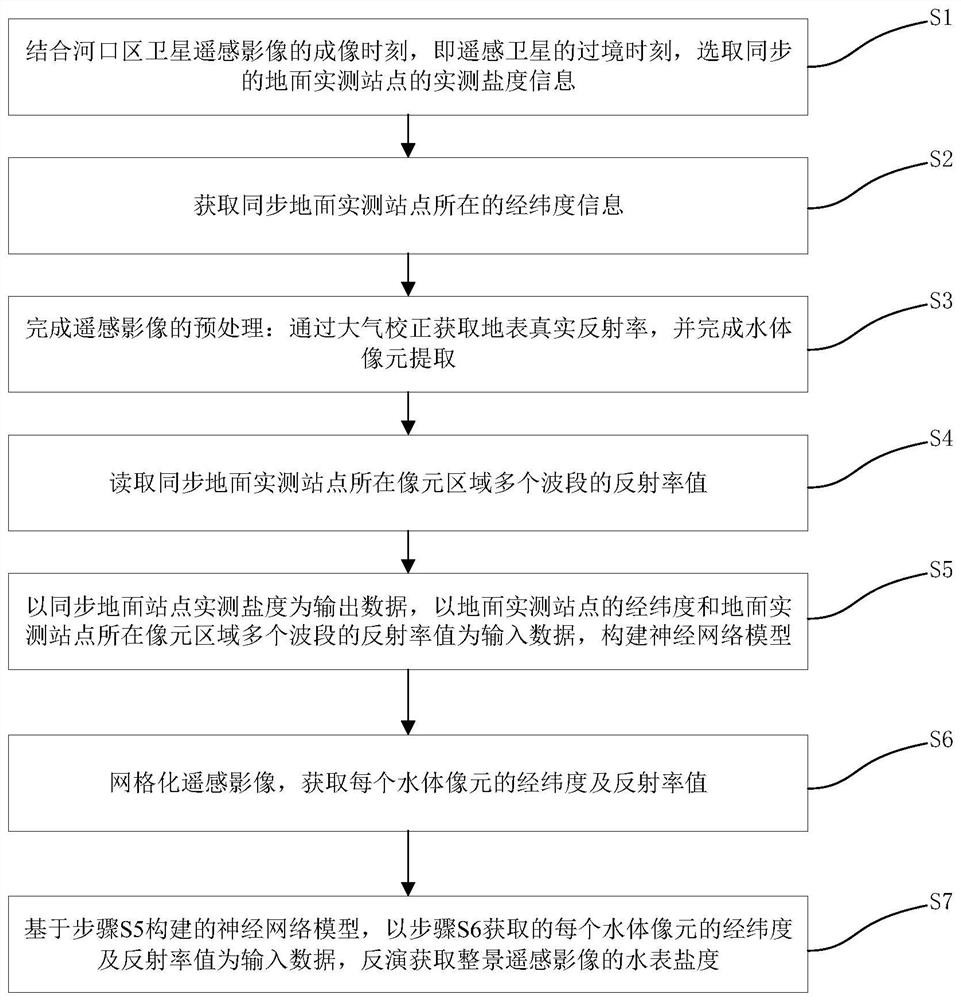
[0056] Such as figure 1 As shown, this embodiment provides a remote sensing retrieval method for water surface salinity in the estuary area based on satellite-ground coordination, including the following steps:

[0057] S1: Combining the imaging time of satellite remote sensing images in the estuary area, that is, the transit time of remote sensing satellites, select the measured salinity information of synchronous ground measurement stations; specifically include:

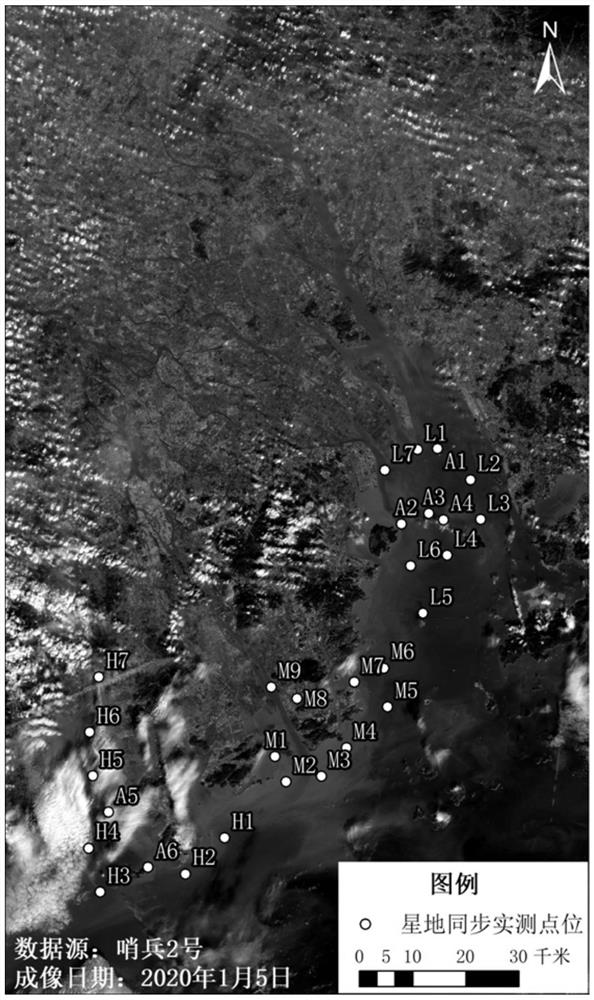
[0058] S1.1: Query satellite remote sensing images of the estuary area; satellite images can be ESA Sentinel 2, domestic Gaofen series (Gaofen 1, Gaofen 2, Gaofen 4, Gaofen 6, etc.), Multispectral remote sensing images such as Domestic Resources No. 3 and US LANDSAT. In this example, the multispectral images of Sentinel No. 2 are used as the remote sensing data source to obtain the water surface salinity distribution of the Pearl River Estuary. According to the inquiry website of Sentinel series satellite images ...

Embodiment 2

[0083] This embodiment provides a remote sensing retrieval system for water surface salinity in the estuary area based on satellite-ground coordination, including a memory and a processor. The following steps are realized when the remote sensing retrieval method of water surface salinity in the estuary area based on satellite-ground coordination is executed by the processor: including the following steps:

[0084] S1: Combining the imaging time of satellite remote sensing images in the estuary area, that is, the transit time of remote sensing satellites, select the measured salinity information of synchronous ground measurement stations;

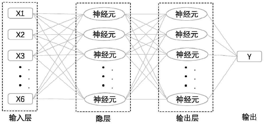
[0085] S2: Read the latitude and longitude information of the synchronous ground measurement site, record the longitude as X1 and the latitude as X2;

[0086] S3: Complete the preprocessing of remote sensing images, obtain the true reflectance of the ground surface through atmospheric correction, and complete the extraction of water body pix...


PUM


Abstract

The invention provides a remote sensing inversion method and system for the water meter salinity of an estuary region based on satellite-ground collaboration, on one hand, high-precision ground actual measurement data of the estuary region are utilized, synchronous ground actual measurement site actual measurement data serve as output data to construct a model, and the inversion precision of the remote sensing inversion model is improved; on the other hand, the situation that a traditional remote sensing inversion model inverts the water meter salinity only through spectral information or indirect water quality parameters is improved, geographic grid information is added to serve as input parameters, and the longitude and latitude information of a ground actual measurement site and a remote sensing image and the data characteristic of spatial continuity of the remote sensing image are fully utilized; and the method and system are especially suitable for realizing high-precision inversion of the salinity of the water meter in the complex estuary region.

Description

technical field [0001] The invention relates to the field of water environment monitoring, and more specifically, to a remote sensing retrieval method and system for water surface salinity in an estuary area based on satellite-ground coordination. Background technique [0002] Salt tide is a unique natural phenomenon in the estuary area. Salt tide intrusion refers to the phenomenon that the high salt water outside the estuary is transported and mixed upward along the estuary with the ebb and flow of the tide, causing the water body in the upstream channel to become salty. In recent years, due to factors such as dry winter water in the Pearl River Basin, sea level rise, and river incisions, salt tides have occurred frequently in the Pearl River Estuary, endangering people's production / living safety and the surrounding water ecological environment, and seriously affecting the Guangdong-Hong Kong-Macao Greater Bay. water security in the area. Effective monitoring of water sali...

Claims


Application Information

Patent Timeline
Patent Type & Authority Applications(China)
IPC IPC(8): G06V20/13G06N3/08G06F16/29G01N21/55G01N21/17G06V10/82
CPCG01N21/17G01N21/55G06N3/084G06F16/29G01N2021/1793
Inventor 冯佑斌何颖清杨芳扶卿华翁忠华郭珊潘洪洲熊龙海刘超群唐庆忠杨松涛俞国松刘茉默吴俊涌张嘉珊
Owner PEARL RIVER HYDRAULIC RES INST OF PEARL RIVER WATER RESOURCES COMMISSION
Why Eureka
Try Eureka