Tree number measuring device based on visible light remote sensing of unmanned aerial vehicle and measuring method of tree number measuring device

A technology of quantity measurement and UAV, which is applied in the field of UAV aerial survey, can solve the problems of high operating cost, low measurement accuracy, long delivery time of analysis images, etc., to overcome high cost, improve cleaning degree, eliminate The effect of poor image quality

Pending Publication Date: 2022-02-25
四川省自然资源科学研究院
View PDF0 Cites 0 Cited by
  • Summary
  • Abstract
  • Description
  • Claims
  • Application Information

AI Technical Summary

Problems solved by technology

[0003] At present, the method of measuring the number of trees in the forest is generally measured by radar or satellite remote sensing. The radar measurement was not only costly, but also the accuracy of the measurement was not high, and the satellite remote sensing imaging technology will be affected by the low return frequency, The limitations of low spatial resolution, high operating cost, high complexity, an...

Method used


Image

  • Tree number measuring device based on visible light remote sensing of unmanned aerial vehicle and measuring method of tree number measuring device

Examples


Embodiment 1

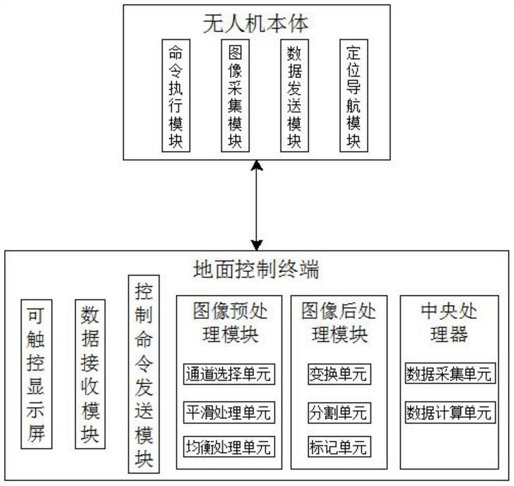
[0025] see figure 1 This embodiment provides a device for measuring the number of trees based on UAV visible light remote sensing, including a UAV body and a ground control terminal, the UAV body and the ground control terminal are remotely connected wirelessly, and a command execution module is provided in the UAV body , image acquisition module, data transmission module and positioning and navigation module. The image acquisition module is a visible light remote sensing device that collects forest images. The command execution module controls the drone body to perform tasks including flight height, flight route, flight speed and shooting point location. ;

[0026] The ground control terminal is equipped with a data receiving module, a control command sending module, an image preprocessing module, an image postprocessing module and a central processing unit. The ground control terminal is also equipped with a touchable display screen for displaying data and inputting unmanned...

Embodiment 2

[0034] This embodiment provides a method for measuring the number of trees based on the visible light remote sensing of the UAV, including the following steps:

[0035] Step 1: First, send the drone control command to the drone body through the ground control terminal, and then the drone body will fly in the area to be measured above the forest according to the drone control command and perform forest image collection;

[0036] Step 2: After the UAV body collects the forest image, the forest image is remotely transmitted to the ground control terminal. At this time, the channel selection unit in the ground control terminal uses the component method to simplify the collected forest image into R channel, G channel and The forest image of channel B, and select the forest image with the best quality among the three channels, and then use the equalization processing unit to equalize the forest with the best quality to obtain an equalized forest image, and then use the smoothing proc...


PUM


Abstract

The invention discloses a tree number measuring device based on unmanned aerial vehicle visible light remote sensing and a measuring method of the tree number measuring device. The device comprises an unmanned aerial vehicle body and a ground control terminal. According to the method, a forest image obtained based on unmanned aerial vehicle visible light remote sensing is taken as data, automatic statistical calculation of the number of forest trees is realized, channel selection, balance processing and smoothing processing are performed on the forest image, the forest image cleaning degree is improved, and the problem of low image quality can be eliminated; through carrying out image transformation, image segmentation and tree canopy center point position extraction on the forest image, the problem that the tree canopy spacing in the image is too small is solved, the effect of accurately measuring the number of trees is achieved, the problems that a traditional radar or satellite remote sensing measurement mode is high in cost, low in efficiency, low in timeliness and high in cost and labor consumption are solved, the requirements of modern forestry development can be met, and effective help is provided for dynamic monitoring of forest succession, quantitative analysis of forest structures and biomass estimation.

Description

technical field [0001] The invention relates to the technical field of aerial survey of unmanned aerial vehicles, in particular to a device for measuring the number of trees based on visible light remote sensing of unmanned aerial vehicles and a measuring method thereof. Background technique [0002] Forests, including arbor forests, bamboo forests and shrub forests specially stipulated by the state, can be divided into protective forests, special-purpose forests, timber forests, economic forests and energy forests according to their uses. Animals, microorganisms and soil are interdependent and restrict each other, and interact with the environment to form an ecosystem as a whole. It has rich species, complex structures, and diverse functions. Forests are an important part of terrestrial ecosystems. It is also one of the important natural resources for human survival and development. As an important part of forestry research, timely and accurate statistics of forest informat...

Claims


Application Information

Patent Timeline
IPC IPC(8): G06V10/762G06V10/26G06V20/17G06K9/62G06T5/00G06T7/66G06T7/90
CPCG06T7/90G06T7/66G06T5/002G06F18/23
Inventor 张洪吉陈青松谭小琴杨红宇
Owner 四川省自然资源科学研究院
Why Eureka
Try Eureka