Land surveying and mapping system based on Internet of Things technology

An Internet of Things technology and land technology, which is applied in the field of land surveying and mapping, can solve the problems of insufficient measurement accuracy of the land surveying and mapping system, insignificant effects of heat insulation and waterproofing, and no humidity detection and drying. Avoid damage to electronic components, good waterproof effect

Inactive Publication Date: 2022-03-11
宋双玲
View PDF0 Cites 0 Cited by
  • Summary
  • Abstract
  • Description
  • Claims
  • Application Information

AI Technical Summary

Problems solved by technology

[0003] The land surveying and mapping system has the following disadvantages: 1. The measurement accuracy of the land surveying and mapping system is not high enough, and the stability is poor; 2. It does not have the functions of humidity detection and drying; 3. The effect of heat insulation and waterproofing is not obvious

Method used


Image

  • Land surveying and mapping system based on Internet of Things technology
  • Land surveying and mapping system based on Internet of Things technology
  • Land surveying and mapping system based on Internet of Things technology

Examples


Embodiment Construction

[0023] In order to make the technical means, creative features, goals and effects achieved by the present invention easy to understand, the present invention will be further described below in conjunction with specific embodiments.

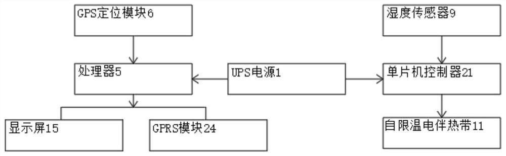
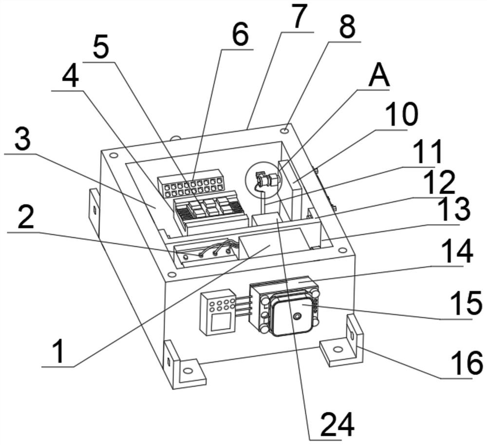
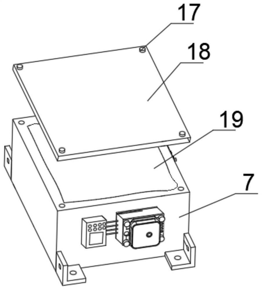
[0024] Such as Figure 1-5 As shown, a land surveying and mapping system based on the Internet of Things technology includes a box body 7, a box cover 18 and a mounting piece 16. One end of the box body 7 is provided with a control compartment 3, and the control compartment 3 is provided through a card slot. There is a GPS positioning module 6, one end of the GPS positioning module 6 is equipped with a processor 5 through a rubber limit seat 4 and screws, and one side of the inner wall of the control chamber 3 is bonded with a water-absorbing cotton 10 by curing glue. One side of the cotton 10 is equipped with a single-chip controller 21 by a spacer 20 and a screw, and one end of the single-chip controller 21 is connected with a humidity sensor 9 ...


PUM


Abstract

The invention discloses a land surveying and mapping system based on the Internet of Things technology, which comprises a box body, a box cover and a mounting piece, a control bin is arranged at one end in the box body, a GPS positioning module is arranged in the control bin through a clamping groove, one end of the GPS positioning module is provided with a processor through a rubber limiting seat and a screw, and the other end of the GPS positioning module is provided with a wireless communication module. Water absorption cotton is bonded to one side of the inner wall of the control bin through curing glue, a single-chip microcomputer controller is installed on one side of the water absorption cotton through a limiting piece and a screw, a humidity sensor is connected to one end of the single-chip microcomputer controller through a screw, and a self-temperature-limiting electric tracing band is installed at the lower end of the humidity sensor through a ceramic fixing buckle; one end of the box body is provided with a display screen through a display frame and screws. The land surveying and mapping system is high in measurement precision and good in stability, has humidity detection and drying functions, is obvious in heat insulation and waterproof effects, and is suitable for wide popularization and application.

Description

technical field [0001] The invention relates to the technical field of land surveying and mapping, in particular to a land surveying and mapping system based on Internet of Things technology. Background technique [0002] Land surveying and mapping refers to the use of computer technology, photoelectric technology, network communication technology, space science, and information science as the basis, with the global positioning system (GPS), remote sensing (RS), and geographic information system (GIS) For some feature points and boundaries, the graphics and position information reflecting the current situation of the ground are obtained by means of measurement, which are used for planning, design and administrative management of engineering construction. The main work is to carry out cadastral survey control points, field selection of boundary points, burial of rocks, and use of theodolite and other instruments to observe the distance, horizontal angle, vertical angle, and l...

Claims


Application Information

Patent Timeline
Patent Type & Authority Applications(China)
IPC IPC(8): G01C15/00G01S19/14G08C17/02G05D22/02
CPCG01C15/00G01S19/14G08C17/02G05D22/02
Inventor 宋双玲
Owner 宋双玲
Why Eureka
Try Eureka