
GPS remote sensing flood warning method based on artificial intelligence decision tree

An artificial intelligence and decision tree technology, which is applied in the field of remote sensing inversion of navigation satellites, can solve problems such as large differences in carrier-to-noise ratio observations, restrictions on receiver types, and lack of output carrier-to-noise ratio, etc., to ensure the detection success rate and Stability, ensure detection accuracy and stability, and improve the effect of detection accuracy

Active Publication Date: 2022-07-05
浙江国遥地理信息技术有限公司
View PDF0 Cites 0 Cited by
  • Summary
  • Abstract
  • Description
  • Claims
  • Application Information

AI Technical Summary

Problems solved by technology

[0003] At present, flood detection methods based on navigation satellite inversion can be mainly divided into two categories from the perspective of observation values. The first category is flood early warning detection based on signal carrier-to-noise ratio observations, but the performance of carrier-to-noise ratio in different arcs The difference is large, especially in the process of flood detection, the CNR fluctuation is more obvious in the high arc section (the altitude angle is greater than 60 degrees) than in the low arc section (the altitude angle is lower than 30 degrees), which leads to the conventional The efficiency of the detection method with low arc carrier-to-noise ratio is reduced
In addition, the detection method based on carrier-to-noise ratio is severely restricted by the type of receiver
For example, the observed value of carrier-to-noise ratio output by receivers of different manufacturers is very different, making it difficult to establish a uniform and standardized detection threshold
However, some carrier-to-noise ratios use approximate output, resulting in lower resolution of the carrier-to-noise ratio, which seriously reduces the accuracy of flood detection.
In addition, some receivers do not have the function of outputting carrier-to-noise ratio, which will make this method invalid
The second type is flood detection and early warning based on pseudorange and carrier phase observations, but the existing methods are based on the combination of pseudorange and carrier phase observations, and the combination of observations will cause noise and other errors (such as tropospheric residuals and ionospheric residuals), resulting in low accuracy of existing detection methods based on pseudorange and carrier phase observations
In addition, the current method does not take into account the influence of gross errors on the observed values, resulting in a low detection success rate, while the establishment of the detection model ignores the correlation of characteristic parameters, which also leads to a high false detection rate in the existing method, resulting in excessive false alarm

Method used


Image

  • GPS remote sensing flood warning method based on artificial intelligence decision tree
  • GPS remote sensing flood warning method based on artificial intelligence decision tree
  • GPS remote sensing flood warning method based on artificial intelligence decision tree

Examples


Embodiment Construction

[0106] It should be noted that the embodiments of the present invention and the features of the embodiments may be combined with each other under the condition of no conflict.

[0107] In the description of the present invention, it should be understood that the terms "center", "portrait", "horizontal", "top", "bottom", "front", "rear", "left", "right", " The orientation or positional relationship indicated by vertical, horizontal, top, bottom, inner, outer, etc. is based on the orientation or positional relationship shown in the drawings, and is only for the convenience of describing the present invention and The description is simplified rather than indicating or implying that the device or element referred to must have a particular orientation, be constructed and operate in a particular orientation, and therefore should not be construed as limiting the invention. In addition, the terms "first", "second", etc. are used for descriptive purposes only, and should not be constru...


PUM


Abstract

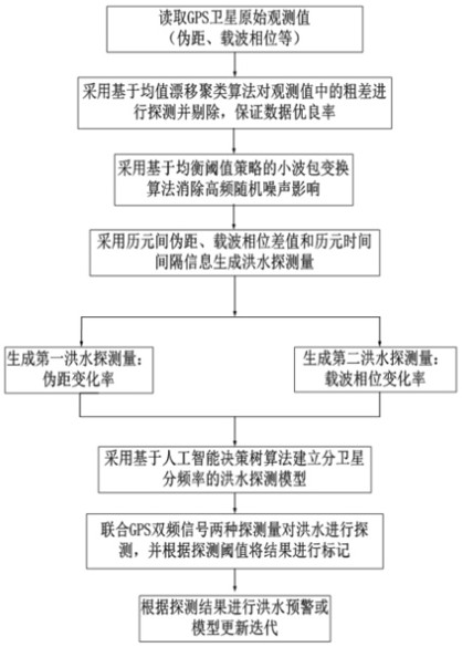
The invention discloses a GPS remote sensing flood prediction method based on an artificial intelligence decision tree, comprising the following steps: S1, reading the original observation value of GPS satellite; S2, preprocessing the original observation value; S3, adopting the pseudo-range between epochs The information of the difference, the carrier phase difference and the epoch time interval generates a flood detection amount, and the flood detection amount includes a first detection amount and a second detection amount; S4, using an artificial intelligence-based decision tree algorithm to establish a sub-satellite sub-frequency flood detection model; S5, combine the first detection quantity and the second detection quantity of the GPS dual-frequency signal to detect the flood, and mark the result according to the detection threshold; S6, perform flood warning according to the detection result or update and iterate the flood detection model. The artificial intelligence-based decision tree algorithm is used to establish a high-precision flood detection model, and the correlation between the detection amount and other auxiliary characteristic parameters is deeply excavated to reduce the false detection rate and ensure the accuracy and stability of flood detection.

Description

technical field [0001] The invention relates to the technical field of navigation satellite remote sensing inversion, in particular to a GPS remote sensing flood prediction method based on an artificial intelligence decision tree. Background technique [0002] With global warming and changes in urban hydrological effects caused by the development of urbanization, extreme heavy rainfall weather is extremely easy to cause urban waterlogging and local floods in cities and towns, making the risk of urban flooding constantly increasing. For example, urban floods occurred in Wuhan City, Hubei Province in early July 2016, local floods in urban and rural areas in Hami City, Xinjiang in July 2018, and local floods in Xinxiang, Henan Province in July 2021, etc., causing dozens of People died, and the direct economic loss was as high as 3 billion yuan. It can be seen that short-term local waterlogging and floods in the city seriously threaten the safety of people's lives and properties...

Claims


Application Information

Patent Timeline
Patent Type & Authority Patents(China)
IPC IPC(8): G06F30/27G06K9/00G06K9/62G01W1/10G01S19/39G06F111/08G06F113/08G06F119/10
CPCG06F30/27G01W1/10G01S19/39G06F2111/08G06F2113/08G06F2119/10G06F2218/06G06F18/23G06F18/24323G06F18/214Y02A10/40Y02A90/10
Inventor 马广迪杨为琛张国杨生娟李天宇孔诗元施妍慧
Owner 浙江国遥地理信息技术有限公司
Learn More