Airborne flood data processing method, device and system based on aviation emergency mode

An emergency mode and data processing technology, applied in the field of aerial remote sensing, can solve the problems of low processing efficiency of remote sensing data and lack of current situation, and achieve the effect of improving information processing efficiency, current situation and obvious significance

Pending Publication Date: 2022-04-15
AEROSPACE INFORMATION RES INST CAS
View PDF0 Cites 0 Cited by
  • Summary
  • Abstract
  • Description
  • Claims
  • Application Information

AI Technical Summary

Problems solved by technology

[0005] The present invention provides an on-board flood data processing method, device and system based on the aviation emergency mode, which is used to solve the defects in the prior art that the remote sensing data processing efficiency of flood submersion is low and does not have current status, and realizes the comprehensive flood on-board Analyze information processing, reduce the time difference between data acquisition and data use, and ensure high data efficiency and high current status

Method used


Image

  • Airborne flood data processing method, device and system based on aviation emergency mode
  • Airborne flood data processing method, device and system based on aviation emergency mode
  • Airborne flood data processing method, device and system based on aviation emergency mode

Examples


specific Embodiment approach

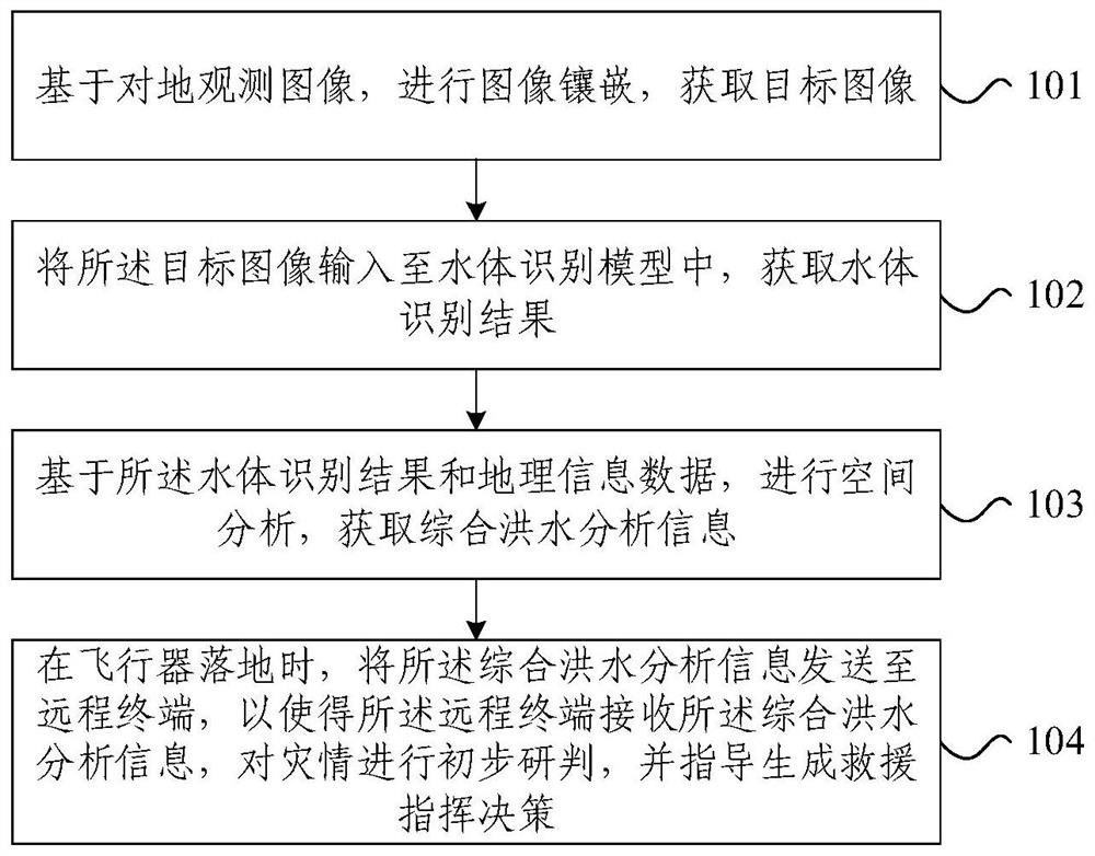
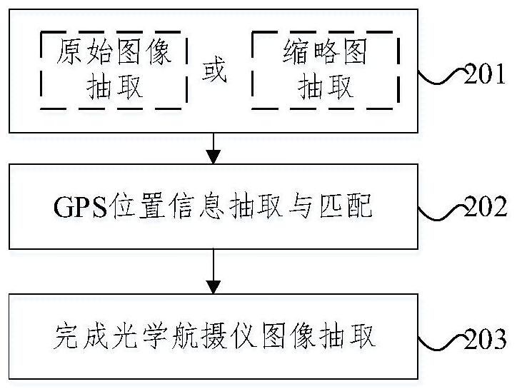
[0135] Step 201 , according to the capability level of the on-board computer and the urgency of the disaster, extract the target observation image or the thumbnail of the target observation image.

[0136] Step 202, extraction and matching of target GPS position information.

[0137] Step 203 , forming a data pair between the target observation image and the target GPS position according to the target exposure time, and completing the extraction of the optical aerial camera image.

[0138] In the embodiment of the present invention, based on the target parameters, the target exposure time is recorded while the target observation image is extracted, and the target GPS position information is associated with the target observation image through the target exposure time. Under the condition of satisfying a certain precision, the overlapping area between images can be reduced, and the image processing efficiency can be improved. Furthermore, improving the efficiency and current s...


PUM


Abstract

The invention provides an airborne flood data processing method, device and system based on an aviation emergency mode, and the method comprises the steps: carrying out the image mosaic based on an earth observation image, and obtaining a target image; inputting the target image into a water body recognition model to obtain a water body recognition result; based on the water body recognition result and the geographic information data, spatial analysis is carried out, and comprehensive flood analysis information is obtained; and when the aircraft lands, the comprehensive flood analysis information is sent to a remote terminal, so that the remote terminal receives the comprehensive flood analysis information, carries out preliminary study and judgment on the disaster situation, and guides and generates a rescue command decision. According to the airborne flood data processing method, device and system based on the aviation emergency mode, splicing, correction, information extraction and the like of flood data can be completed in real time and quasi real time on the aircraft during flight, after the aircraft lands, the information is transmitted to a ground command system, the information processing efficiency and the instantaneity are improved, and the method, the device and the system are suitable for popularization and application. The significance on emergency rescue is obvious.

Description

technical field [0001] The present invention relates to the technical field of aviation remote sensing, in particular to an on-board flood data processing method, device and system based on aviation emergency mode. Background technique [0002] At present, as one of the main natural disasters, flood disasters cause huge casualties and economic losses every year. For flood emergency rescue work, the basic information of the disaster situation in the affected area should be mastered first, and the general assessment of the disaster situation should be completed to provide necessary guidance information for rescue. [0003] However, during floods, it is often accompanied by heavy rain or cloudy weather. Optical satellite remote sensing cannot continuously collect ground image data during the rescue period due to weather restrictions. Microwave remote sensing satellites have a certain ability to penetrate clouds and rain, but due to the technical difficulty of data processing. ...

Claims


Application Information

Patent Timeline
Patent Type & Authority Applications(China)
IPC IPC(8): G06F16/583G06F16/587G06T3/00G06T7/33G06V20/17
Inventor 李儒潘洁杨宏胡晶晶邓飚
Owner AEROSPACE INFORMATION RES INST CAS
Why Eureka
Try Eureka