Digital rural ecological landscape application platform

An ecological landscape and application platform technology, applied in data processing applications, special data processing applications, electrical digital data processing, etc., can solve the problems of inability to realize data interoperability, impossibility of promotion and use, and high professional requirements, and achieve universal applicability , beneficial to promotion and use, and easy to use

Pending Publication Date: 2022-04-19
SOUTHEAST UNIV
5 Cites 0 Cited by

AI-Extracted Technical Summary

Problems solved by technology

[0003] Existing applications such as rural ecological landscape analysis and management and control rely on independent software to achieve data interoperability. Users need to constantly convert dat...

Abstract

The invention relates to the field of rural ecological landscapes, in particular to a digital rural ecological landscape application platform which comprises a basic operation module, a query statistics module, a thematic application module and a data transmission module. The data transmission module comprises a database transmission end, an ArcMap transmission end, an ArcScene transmission end, a simulation experience transmission end, a public feedback transmission end, a weather early warning transmission end and a government information public transmission end, and is connected with the basic operation module, the query statistics module and the thematic application module; the query statistics module comprises a data query unit, an attribute query unit and a measurement statistics unit; and the thematic application module comprises an evaluation identification unit, an environment management and control unit and a simulation experience unit. According to the invention, the digital requirement of the whole process of the rural ecological landscape can be met, the digital analysis, display, experience and management and control functions of the rural ecological landscape are specifically realized, and the industry blank is filled; in addition, the platform is high in usability, wide in universality and beneficial to popularization and use.

Application Domain

Technology Topic

Image

  • Digital rural ecological landscape application platform
  • Digital rural ecological landscape application platform
  • Digital rural ecological landscape application platform

Examples

  • Experimental program(1)

Example Embodiment

[0035] The technical solutions in the embodiments of the present invention will be clearly and completely described below with reference to the accompanying drawings in the embodiments of the present invention. Obviously, the described embodiments are only a part of the embodiments of the present invention, but not all of the embodiments. Based on the embodiments of the present invention, all other embodiments obtained by those of ordinary skill in the art without creative efforts shall fall within the protection scope of the present invention.
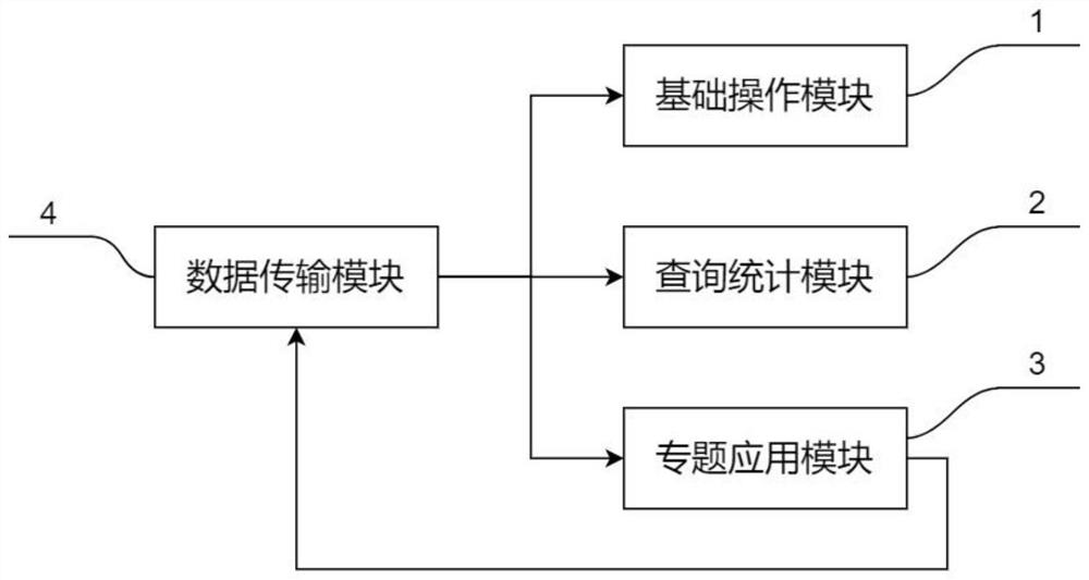
[0036] A digital rural ecological landscape application platform, such as figure 1 As shown, it includes a basic operation module 1, a query statistics module 2, a special application module 3 and a data transmission module 4. The output terminal of the data transmission module 4 and the input terminal of the basic operation module 1, the query statistics module 2 and the special application module 3 are all connected, the output end of the special application module 3 is connected with the input end of the data transmission module 4, and the data transmission module 4 provides the required data and function transmission end for the basic operation module 1, the query statistics module 2 and the special application module 3, At the same time, the new data generated after thematic application can be transferred to the database for management and storage.
[0037] like figure 2 As shown, the data transmission module 4 includes a database transmission terminal, an ArcMap transmission terminal, an ArcScene transmission terminal, a simulation experience transmission terminal, a public feedback transmission terminal, a weather warning transmission terminal and a government information disclosure transmission terminal. On the other hand, it provides the application function docking channel.
[0038] like image 3 As shown, the basic operation module 1 includes a file management unit, a view management unit, a shape drawing unit and a thematic map drawing unit, and the basic operation module 1 is used to realize the basic operation control of the platform.
[0039] Among them, the file management unit is used to load and remove user local data in the platform; the view management unit is used to manage the display layer and adjust the map display effect of the main screen; the shape drawing unit is used to draw rectangles, polygons, circles, curves, etc. A variety of vector shapes; thematic map drawing unit is used to adjust the size of the map, add map decoration such as compass, scale, legend, text, etc., and print the map.
[0040] like Figure 4 As shown, the query statistics module 2 includes a data query unit, an attribute query unit, and a measurement statistics unit, which are used for retrieving data in the database, and viewing and counting the form and attributes of spatial data.
[0041] Among them, the data query unit is connected to the database transmission end, used for fuzzy search of keywords, and by browsing the database catalog, to directly find the required rural ecological landscape data, and then load it into the main window of the platform; the attribute query unit includes click query, graphics Query and query by attribute are used to select the corresponding elements according to a certain selection method, and to query the attributes of the selected elements; the measurement and statistics units include coordinate measurement, distance measurement, and area measurement, which are used for corresponding numerical calculation and statistics.
[0042] like Figure 5 As shown, the thematic application module 3 includes an evaluation and identification unit, an environmental management and control unit and a virtual simulation unit, which are used for rural ecological landscape analysis, management, and experience, and can meet the rural ecological landscape of "basic data-evaluation analysis-governance control-multi-dimensional visualization" Landscape full-process digital requirements.
[0043] Among them, the evaluation and identification unit in the special application module 3 is connected to the ArcMap transmission terminal and the ArcScene transmission terminal at the same time, which are used for the spatial analysis of two-dimensional and three-dimensional states respectively;
[0044]Evaluation and identification units include rural ecological environment evaluation, rural settlement construction evaluation, rural landscape style evaluation, and rural ecological landscape feature identification; among them, rural ecological environment evaluation includes rural ecological sensitivity evaluation, rural ecological suitability evaluation, rural ecological quality evaluation, Rural ecological function evaluation; among them, the evaluation of rural human settlements includes the evaluation of rural landscape development intensity; among them, the evaluation of rural landscape style includes the evaluation of rural landscape characteristics; all kinds of evaluations are based on the calculation methods and models recognized by the academic circles, which are universal and universal ;
[0045] The environmental management and control unit includes administrative management, meteorological inquiry, disaster warning, and public feedback. The environmental management and control unit is connected to the government information disclosure transmission terminal, the weather warning transmission terminal, and the public feedback transmission terminal; among them, the government information disclosure transmission terminal is connected to the administrative management, and the administrative Personnel can issue relevant announcements and notifications through the port; the weather warning transmission terminal is connected to disaster warning and weather query, and can automatically obtain the weather forecast information for the past 5 days directly through the weather forecast network (http://www.weather.com.cn/). The public feedback transmission terminal is connected to the public feedback. Users can give feedback on the rural ecological landscape through the mobile phone applet, and the administrators process the public feedback through the PC terminal of the platform and publish the reply information.
[0046] The simulation experience unit is connected to the simulation experience transmission terminal, including village management, map management, layer management, labeling on the map, panoramic display and online conference hall. It can switch the simulation experience villages and towns online, manage the display map, and adjust the opening and display of simulation data. Add simple positioning tags to the web page, and cooperate with holographic projection technology and VR technology to realize the simulated browsing experience of data overlay scenes and typical rural landscape scenes; online conference hall supports real-time uploading of public opinions and evaluations Online feedback interaction.
[0047] The invention solves the problems of discrete rural ecological landscape information and lack of coordination of application functions through the construction of a digital rural ecological landscape application platform. The function transmission terminal realizes real-time management, control and governance, forming a whole-process, digital operation platform integrating rural ecological landscape information fusion, rural ecological landscape analysis, rural ecological landscape management, control and governance, and rural ecological landscape display.
[0048] The foregoing has shown and described the basic principles, main features and advantages of the present invention. Those skilled in the art should understand that the present invention is not limited by the above-mentioned embodiments, and the descriptions in the above-mentioned embodiments and the description are only to illustrate the principle of the present invention. Without departing from the spirit and scope of the present invention, the present invention will have Various changes and modifications fall within the scope of the claimed invention.

PUM

no PUM

Description & Claims & Application Information

We can also present the details of the Description, Claims and Application information to help users get a comprehensive understanding of the technical details of the patent, such as background art, summary of invention, brief description of drawings, description of embodiments, and other original content. On the other hand, users can also determine the specific scope of protection of the technology through the list of claims; as well as understand the changes in the life cycle of the technology with the presentation of the patent timeline. Login to view more.

Similar technology patents

Management circuit of intelligent material rack

PendingCN114527681AReduce labor and time costsAvoid the influence of uncertain factorsTotal factory controlProgramme control in sequence/logic controllersCommunication interfaceMaterial storage
Owner:深圳铉微科技有限公司

Calculation method and device for feature data of lending user in financial scene

InactiveCN112270599AReduce labor and time costsReduce financial riskFinanceOffice automationEngineeringFeature data
Owner:北京泛钛客科技有限公司

Automatic spraying type reel cleaning device and using method thereof

PendingCN112222052AReduce labor and time costsImprove circulation rateCleaning using liquidsManufacturing engineeringIndustrial engineering
Owner:江苏上达半导体有限公司

Classification and recommendation of technical efficacy words

  • Reduce labor and time costs
  • Good control

Data quality detection method and device and storage medium

PendingCN109656812AImprove accuracy and coverageReduce labor and time costsDigital data information retrievalSoftware testing/debuggingMetadataAutomation
Owner:PING AN TECH (SHENZHEN) CO LTD

IP address batch modification method and system for embedded devices with same IP

InactiveCN107222589AImprove work efficiencyReduce labor and time costsTransmissionClient-sideIp address
Owner:NANJING GUODIAN NANZI WEIMEIDE AUTOMATION CO LTD

Battery module

ActiveCN105655512AImprove efficiencyReduce labor and time costsCell component detailsFastenerSurface plate
Owner:ZAOZHUANG HAIDI ENERGY TECH

Stent Positioning Using Inflation Tube

InactiveUS20070282302A1Less frictionGood controlStentsGuide needlesPush and pullBalloon inflation
Owner:F D CARDIO

Programmable domestic water heating system

InactiveUS6936798B2Good controlReliable indicationCooking vesselsCentral heating component positioningUse of timeTemperature sense
Owner:JOSEPH TIRAN
Why Eureka
Try Eureka