Ionized layer tomography method based on multi-source data driving

A tomography, multi-source data technology, applied in image data processing, 2D image generation, graphic image conversion, etc., can solve the problems of low vertical resolution and insufficient algorithm stability, and achieve the effect of improving reconstruction accuracy.

Pending Publication Date: 2022-04-22
中国电波传播研究所
View PDF0 Cites 1 Cited by
  • Summary
  • Abstract
  • Description
  • Claims
  • Application Information

AI Technical Summary

Problems solved by technology

However, limited by the scanning angle of view and the non-uniform distribution of the number of stations, the quality of ionospheric CT results based on ground-based data is extremely dependent on the accuracy of the background ionospheric model, and there are varying degrees of low vertical resolution, Insufficient algorithm stability and other issues

Method used


Image

  • Ionized layer tomography method based on multi-source data driving
  • Ionized layer tomography method based on multi-source data driving
  • Ionized layer tomography method based on multi-source data driving

Examples


Embodiment 1

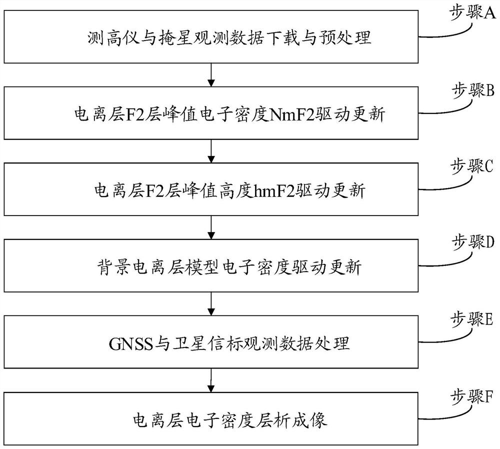
[0118] Example 1, such as figure 1 As shown, this embodiment discloses a multi-source data-driven ionospheric tomography method, including the following steps:

[0119] Step A, downloading and preprocessing of altimeter and occultation observation data:

[0120] Step A1, download the altimeter automatic interpretation data, the data sources include the Global Ionospheric Radio Observatory (Global Ionospheric Radio Observatory, GIRO), the Space Physics Interactive Data Resource Network (TheSpace Physics Interactive Data Resource, SPIDR) and China Radio Propagation Research China Research Institute of Radiowave Propagation (CRIRP) Altimeter Observation Network;

[0121] Step A2, download COSMIC satellite, GRACE satellite, electron density profile data product (IonPrf) released by COSMIC Data Analysis and Archive Center (CDAAC);

[0122] Step A3, extract the ionospheric F2 peak electron density NmF2 value and peak height hmF2 value of all observation data, marked as {x 1 ,x 2...


PUM


Abstract

The invention discloses an ionosphere tomography method based on multi-source data driving. The ionosphere tomography method comprises the following steps: step A, downloading and preprocessing altimeter and occultation observation data; b, the peak electron density NmF2 of the ionized layer F2 is driven and updated; c, performing driving updating on the peak height hmF2 of the ionized layer F2; step D, performing electron density driving updating on the background ionized layer model; step E, GNSS and satellite beacon observation data processing; and step F, ionosphere electron density tomography. According to the method disclosed by the invention, the background ionosphere model is effectively updated by utilizing a data driving method by utilizing the characteristic that the ionosphere altimeter and occultation vertical observation are relatively high in resolution, and on the basis, ionosphere tomography is carried out by utilizing a ground-based GNSS and a TEC observed by a satellite beacon; and the reconstruction precision of the electron density of the three-dimensional ionized layer can be effectively improved.

Description

technical field [0001] The invention belongs to the technical field of ionospheric environment remote sensing, in particular to an ionospheric tomography method driven by multi-source data in this field. Background technique [0002] The ionosphere refers to the ionized region of the atmosphere at an altitude of 60 kilometers to 1000 kilometers above the earth. Radio waves passing through this region will produce refraction, reflection, scattering and absorption effects, thus affecting navigation, communication, measurement and control, remote sensing and many other radio information systems. performance. Using various technical means to obtain the characteristic parameters of the ionosphere, to study various phenomena in the ionosphere, and to reveal the physical mechanism behind it has important scientific and even political, military and economic significance. Electron density is one of the most direct characteristic parameters to characterize the state of the ionosphere...

Claims


Application Information

Patent Timeline
Patent Type & Authority Applications(China)
IPC IPC(8): G01S19/37G06T11/00G06T3/40
CPCG01S19/37G06T11/003G06T3/4007
Inventor 欧明甄卫民冯健吴家燕陈龙江王妍许娜陈亮马宝田刘钝於晓陈丽
Owner 中国电波传播研究所
Why Eureka
Try Eureka