
Multifunctional integrated surveying and mapping instrument for geological survey

A geological survey and surveying and mapping instrument technology, applied in the direction of measuring instrument components, instruments, measuring devices, etc., can solve the problems that the tripod does not have a fine-tuning structure, is not high in practicability, and has high labor intensity, so as to improve flexibility, use convenience, The effect of reducing labor intensity

Inactive Publication Date: 2022-05-10
山东省地质矿产勘查开发局第四地质大队
View PDF0 Cites 4 Cited by
  • Summary
  • Abstract
  • Description
  • Claims
  • Application Information

AI Technical Summary

Problems solved by technology

[0003] However, as far as the supporting tripod of the current surveying and mapping instrument is concerned, it is a first-level telescopic structure with poor flexibility, and the screw rod for adjusting and locking the tripod is arranged at the bottom of the outer rod body. It is necessary to bend down frequently to adjust the use angle of the tripod. The steps are cumbersome and labor-intensive. Fine-tuning is required during the tripod support process. The existing tripod does not have a fine-tuning structure. When fine-tuning the tripod is required, it can only be done by rotating the fixing bolts. It is more troublesome to fine-tune the telescopic length of the tripod rod body according to the degree of tightness, the accuracy is poor, and the practicability is not high.

Method used


Image

  • Multifunctional integrated surveying and mapping instrument for geological survey
  • Multifunctional integrated surveying and mapping instrument for geological survey
  • Multifunctional integrated surveying and mapping instrument for geological survey

Examples


Embodiment

[0035] Example: Please refer to Figure 1 to Figure 10 :

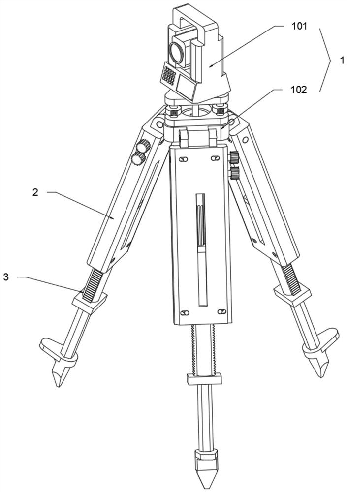
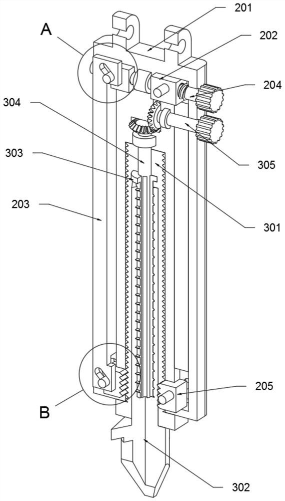
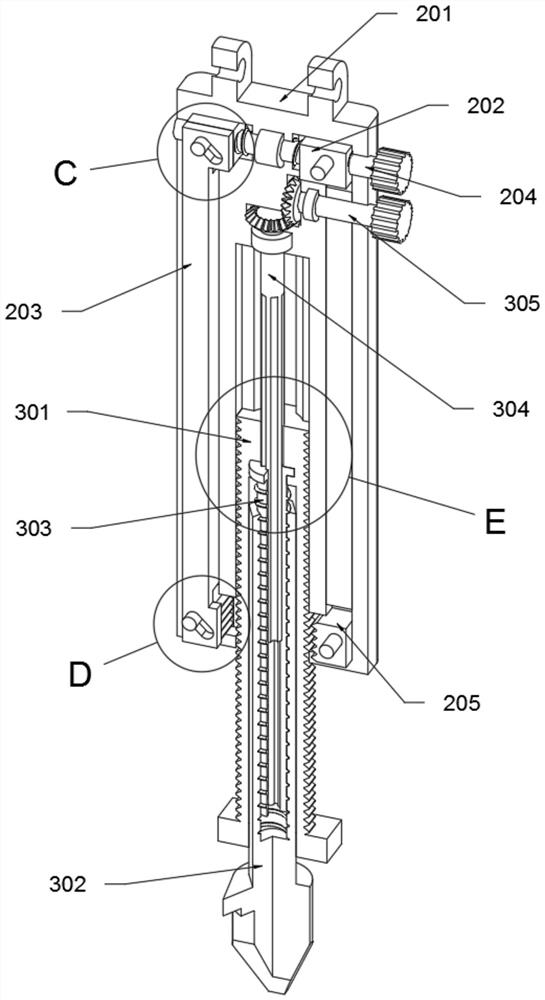
[0036]The present invention proposes a multifunctional integrated surveying instrument for geological survey, comprising: a measuring assembly 1, the measuring assembly 1 includes a surveying instrument body 101 and a mounting seat 102, the surveying instrument body 101 is fixedly installed on the top of the mounting seat 102, and A bracket assembly is installed on the side of the mounting base 102; the bracket assembly is composed of a coarse adjustment mechanism 2 and a fine adjustment mechanism 3, and the coarse adjustment mechanism 2 includes a first-level sleeve rod 201, a control block 202, a linkage vertical rod 203, a locking rod 204 and a lock The stop block 205, the first-level sleeve rod 201 is rotatably connected to the side of the mounting base 102, and the control block 202 is plugged into the top of the first-level sleeve rod 201, and the linkage vertical rod 203 is inserted into the inside of the first-...


PUM


Abstract

The invention provides a multifunctional integrated surveying and mapping instrument for geological survey, and relates to the technical field of surveying and mapping devices, the multifunctional integrated surveying and mapping instrument comprises a fine adjustment mechanism, a three-stage fine adjustment rod is inserted into a two-stage telescopic rod, and a support assembly can realize two-stage telescopic use under the matching action of a first-stage sleeve rod, the two-stage telescopic rod and the three-stage fine adjustment rod; the device is more flexible to support and use, the locking rod and the adjusting rod are both arranged at the top of the first-stage sleeve rod, so that a worker can conveniently support and use the device, the labor intensity of the worker is greatly reduced, the device can be rapidly and roughly supported by the coarse adjusting mechanism, and the use and supporting state of the device can be finely adjusted by the fine adjusting mechanism; the tripod is simple in structure and convenient to use, and the problems that an existing tripod is of a first-level telescopic structure and is poor in flexibility, workers need to frequently bend down to adjust the use angle of the tripod in the instrument erecting process, labor intensity is large, and the tripod is not provided with a fine adjustment structure are solved.

Description

technical field [0001] The invention relates to the technical field of surveying and mapping devices, in particular to a multifunctional integrated surveying and mapping instrument for geological survey. Background technique [0002] In the process of geological survey, surveying and mapping instruments are needed. Simply speaking, surveying and mapping instruments are instruments and devices designed and manufactured for data acquisition, processing, and output. With the development of science and technology, the current surveying and mapping instruments have been It is more and more intelligent, with complete functions, capable of various orientation, distance measurement, angle measurement, height measurement, mapping and photogrammetry, which facilitates the staff's geological survey operations. The surveying and mapping instruments need to be used with a tripod for support. . [0003] However, as far as the supporting tripod of the current surveying and mapping instrum...

Claims


Application Information

Patent Timeline
IPC IPC(8): F16M11/32G01D11/30
CPCF16M11/32G01D11/30F16M2200/028
Inventor 迟娜韩凯
Owner 山东省地质矿产勘查开发局第四地质大队
Learn More