
Karst cave three-dimensional imaging method based on ground penetrating radar multi-attribute fusion

A ground penetrating radar and three-dimensional imaging technology, which is applied in the field of three-dimensional imaging of karst caves, can solve the problems of medium dispersion randomness and anisotropy, calculation accuracy and calculation efficiency restricting ground penetrating radar, etc., and achieve the effect of improving accuracy

Pending Publication Date: 2022-05-10
广西新发展交通集团有限公司 +1
View PDF0 Cites 2 Cited by
  • Summary
  • Abstract
  • Description
  • Claims
  • Application Information

AI Technical Summary

Problems solved by technology

However, most of the current research is still in the stage of theoretical research, and various imaging methods are easily affected by factors such as medium dispersion, randomness, and anisotropy when applied to actual engineering cases.
Calculation accuracy and efficiency are still bottlenecks restricting the development of ground penetrating radar imaging technology

Method used


Image

  • Karst cave three-dimensional imaging method based on ground penetrating radar multi-attribute fusion
  • Karst cave three-dimensional imaging method based on ground penetrating radar multi-attribute fusion
  • Karst cave three-dimensional imaging method based on ground penetrating radar multi-attribute fusion

Examples


Embodiment 1

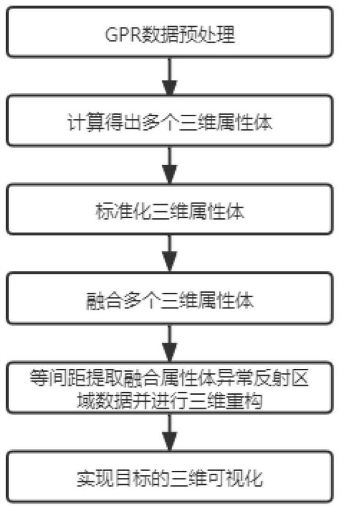
[0040] Such as figure 1 As shown, the three-dimensional imaging method based on ground penetrating radar multi-attribute fusion described in the present invention, the specific operation steps and control conditions are as follows:

[0041] (1) GPR data preprocessing. The main steps of GPR data preprocessing include trace editing, zero-time correction, background removal, gain, band-pass filtering and 3D data synthesis. After multiple data sections are obtained by 3D grid detection on site, each 2D data section is firstly processed according to the above-mentioned preprocessing method. The data preprocessing process and parameter settings of each section should be consistent, and the bandpass filter can be set as 0.5-2.0 times the center frequency, because the spherical dispersion compensation gain (SEC) can maintain the relative amplitude information, so this case chooses the SEC gain function. In addition, for the positions where the diffraction hyperbola is obvious, F-K m...


PUM


Abstract

The invention discloses a karst cave three-dimensional imaging method based on ground penetrating radar multi-attribute fusion. The karst cave three-dimensional imaging method comprises the following steps: (1) preprocessing ground penetrating radar data; (2) calculating the instantaneous amplitude, energy and ground penetrating radar three-dimensional attributes of the maximum amplitude spectrum of the data body obtained through processing in the step (1); (3) normalizing the three three-dimensional attribute bodies in the step (2) by using a range standardization method; (4) fusing the three attribute bodies after the range standardization processing by using a principal component analysis method to obtain a fused attribute body; (5) extracting abnormal reflection region data in the fusion attribute body time slices in the step (4) at equal intervals, and performing three-dimensional reconstruction by using space coordinate information of each slice; and (6) three-dimensional visualization of the tunnel karst cave target body is realized based on the reconstruction data obtained in the step (5) and a volume visualization technology. According to the method, accurate three-dimensional modeling can be effectively carried out on the underground karst cave through the ground penetrating radar, and guidance and help are provided for handling related problems of the underground karst cave in the construction process.

Description

technical field [0001] The invention relates to the field of tunnel geological detection, in particular to a three-dimensional imaging method for karst caves based on multi-attribute fusion of ground penetrating radar. Background technique [0002] When constructing tunnels in karst areas, unfavorable geology such as karst caves and underground rivers are often encountered. The existence of karst seriously restricts the construction period and cost of the tunnel, and poses a serious threat to the safety of construction workers and collective property. The development of karst has the characteristics of complex and changeable and different shapes. Although it can be predicted and estimated macroscopically, it is random and unpredictable locally. Accurately detecting the spatial position and geometry of the cave body and surrounding karst caves during tunnel construction plays an extremely important role in guiding the assessment of disaster risk levels and the formulation of...

Claims


Application Information

Patent Timeline
IPC IPC(8): G01S7/41G01S13/89G01S13/90
CPCG01S7/41G01S7/418G01S13/89G01S13/9094
Inventor 刘宗辉刘毛毛蓝日彦徐一洲高山覃子秀李建合刘家庆王红伟
Owner 广西新发展交通集团有限公司
Learn More