Three-dimensional space shortest path planning method and device based on Beidou grid code

A three-dimensional space, shortest path technology, applied in measurement devices, navigation, instruments, etc., can solve problems affecting user experience, inaccurate calculation results, restricting the development of navigation technology, etc., to improve navigation efficiency and accuracy of navigation results. The effect of user experience

Pending Publication Date: 2022-05-13
GEOVIS CO LTD
View PDF0 Cites 1 Cited by
  • Summary
  • Abstract
  • Description
  • Claims
  • Application Information

AI Technical Summary

Problems solved by technology

However, latitude and longitude are expressed in the form of degrees-minutes-seconds, which is complicated to describe and is not conducive to fast calculation; latitude and longitude represent a point. To represent a planar airspace, it is necessary to determine several corner points of the airspace and the center point of the airspace. Latitude and

Method used


Image

  • Three-dimensional space shortest path planning method and device based on Beidou grid code
  • Three-dimensional space shortest path planning method and device based on Beidou grid code
  • Three-dimensional space shortest path planning method and device based on Beidou grid code

Examples


Embodiment Construction

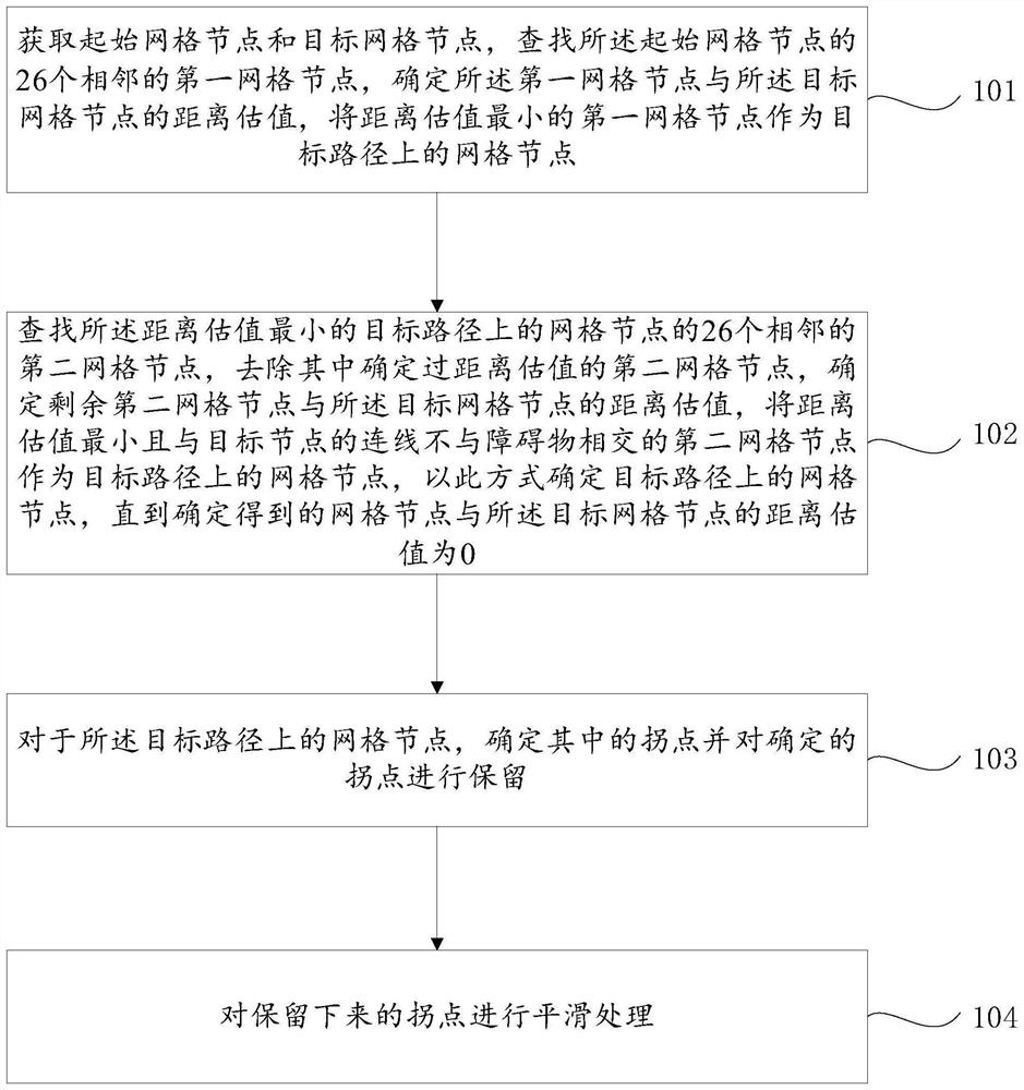
[0045]In order to make the purpose, technical solutions and advantages of the embodiments of the present disclosure clearer, the technical solutions in the embodiments of the present disclosure will be clearly and completely described below in conjunction with the drawings in the embodiments of the present disclosure. Obviously, the described embodiments It is a part of the embodiments of the present disclosure, but not all of them. Based on the embodiments in the present disclosure, all other embodiments obtained by persons of ordinary skill in the art without making creative efforts belong to the protection scope of the present disclosure.

[0046] In addition, the term "and / or" in this article is only an association relationship describing associated objects, which means that there may be three relationships, for example, A and / or B, which may mean: A exists alone, A and B exist at the same time, There are three cases of B alone. In addition, the character " / " in this arti...


PUM


Abstract

The invention provides a three-dimensional space shortest path planning method based on Beidou grid codes, and the method comprises the steps: searching an adjacent grid node of a starting grid node, determining a distance estimation value between the adjacent grid node and a target grid node, and taking the adjacent grid node with the minimum distance estimation value as a grid node on a target path; searching 26 adjacent second grid nodes of the grid nodes on the target path with the minimum distance estimation value, removing the second grid nodes with the determined distance estimation values, and determining the distance estimation values of the remaining second grid nodes and the target grid node, the distance estimation value of the second grid node is minimum, the connecting line of the second grid node and the target node is not intersected with the obstacle, and the grid nodes on the target path are determined in this way; determining an inflection point therein and keeping the inflection point; and carrying out smoothing processing on the reserved inflection points. According to the three-dimensional space shortest path planning method based on the Beidou grid code, the navigation efficiency and the navigation result accuracy can be improved.

Description

technical field [0001] Embodiments of the present disclosure generally relate to the field of space path query, and more specifically, relate to a three-dimensional space shortest path planning method and device based on Beidou grid codes. Background technique [0002] With the rapid development of information technology, the cost of satellite remote sensing and satellite navigation data acquisition has decreased, and geographic information data has shown explosive growth. As a research hotspot in the field of geographic information science, path planning can be obtained from complex and massive geographic information data. Planning out a shortest path from the starting position to the ending position that meets certain criteria in planning has always been one of the key research scenarios in many industries. [0003] There are three main traditional shortest path planning methods, namely breadth-first search algorithm, Dijksra algorithm and best-first search algorithm. [...

Claims


Application Information

Patent Timeline
IPC IPC(8): G01C21/00
CPCG01C21/3863
Inventor 张建学杨光辉王焰辉张敬亮邵宗有
Owner GEOVIS CO LTD
Why Eureka
Try Eureka