Helicopter route planning map processing method based on terrain gradient binaryzation

A processing method and trajectory planning technology, applied in the field of unmanned aerial vehicles, can solve the problems of low efficiency of trajectory planning, information redundancy, large amount of digital elevation map data, etc., to solve the problem of low efficiency of trajectory planning and reduce memory usage , the effect of improving efficiency

Active Publication Date: 2022-05-13
NORTHWESTERN POLYTECHNICAL UNIV
View PDF6 Cites 1 Cited by
  • Summary
  • Abstract
  • Description
  • Claims
  • Application Information

AI Technical Summary

Problems solved by technology

[0003] Aiming at the deficiencies in the prior art, the purpose of the present invention is to provide a method for processing helicopter track planning maps based on terrain gradient binarization, so as to solve the problems caused by the large amount of digital elevation map data and information redundancy in the prior art. Technical problems of low trajectory planning efficiency

Method used


Image

  • Helicopter route planning map processing method based on terrain gradient binaryzation
  • Helicopter route planning map processing method based on terrain gradient binaryzation
  • Helicopter route planning map processing method based on terrain gradient binaryzation

Examples


example 1

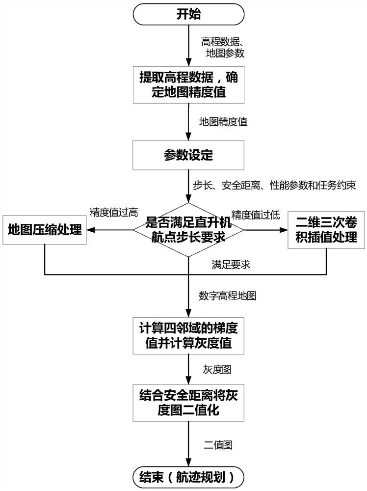
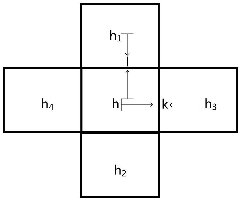
[0129] Using the above-mentioned technical scheme, the track planning test is carried out in the Tibet area, and the original topographic map of the Tibet area is collected, such as Figure 6shown. The map parameters and simulation data extracted from the original topographic map are shown in Table 1. After comparing the step size required by different helicopter waypoints with the map accuracy value calculated by the map parameters, it is judged whether the digital elevation map needs to be processed. Then calculate the gradient value of the elevation data to generate the grayscale image of the maximum terrain gradient value. Figure 7(a) is the grayscale image generated after compression processing, and Figure 7(b) is the grayscale image generated without compression processing. Binarize the obtained gray value combined with the safety distance of helicopter flight to obtain a binary image. Figure 8(a) is the binary image generated after compression processing, and Figure 8(b...

example 2

[0133] Using the above technical scheme, the track planning test is carried out in the hilly terrain area of ​​Shaanxi area, and the original topographic map of the hilly terrain area in Shaanxi area is collected, such as Figure 9 As shown, the map parameters and simulation data extracted from the original topographic map are shown in Table 2. After comparing the step size required by different helicopter waypoints with the map accuracy value calculated by the map parameters, it is judged whether it is necessary to modify the digital elevation map. to process. Then calculate the gradient value of the elevation data to generate the grayscale image of the maximum terrain gradient value. Figure 10(a) is the grayscale image generated after compression processing, and Figure 10(b) is the grayscale image generated without compression processing. Binarize the obtained gray value combined with the safety distance of helicopter flight to obtain a binary image. Figure 11(a) is a binary...


PUM


Abstract

The invention discloses a helicopter flight path planning map processing method based on terrain gradient binaryzation, which comprises the following steps: extracting elevation data and map parameters in a digital elevation map, and determining a map precision value k according to the map parameters; the step length of input waypoints of the helicopter, the safety distance of helicopter flight, helicopter performance parameters and aircraft parameters under task constraints are set; the step length requirement and the map precision value are compared, and the digital elevation map capable of directly meeting the task requirement is obtained through processing by using algorithms such as an interpolation algorithm and map compression, so that the influence of too high or too low map precision value on the flight path planning effect is avoided; a grey-scale map is generated by calculating a gradient value, so that the efficiency of cost calculation of subsequent route planning is improved; the gray-scale map is binarized by combining helicopter performance parameters and parameters under task requirements, so that the algorithm efficiency is greatly improved for subsequent route planning; the technical problem of low flight path planning efficiency caused by large data volume and information redundancy of a digital elevation map in the prior art is solved.

Description

technical field [0001] The invention belongs to the field of unmanned aerial vehicles and relates to a map processing method, in particular to a method for processing a helicopter track planning map based on terrain gradient binarization. Background technique [0002] With the development of modern science and technology, the information that paper maps can display is not enough to meet people's needs, so digital maps have been born. Digital maps use digital storage technology and can be displayed on electronic screens. Extract, display, modify, analyze, etc. the digital map. The information represented by the digital map is far greater than that of the paper map. In addition, based on people's different needs for map information, it can be selectively loaded, spliced, and combined to form digital maps for different applications. On the digital map, topographic and topographic features can be depicted, the map can be zoomed in or out according to the required proportion, a...

Claims


Application Information

Patent Timeline
Patent Type & Authority Applications(China)
IPC IPC(8): G05D1/10
CPCG05D1/101Y02A90/10
Inventor 李靖张泽武晓东周炜黄骏
Owner NORTHWESTERN POLYTECHNICAL UNIV
Why Eureka
Try Eureka