Accumulated snow depth calculation method and device, computer equipment and readable storage medium
A technology of snow depth and calculation method, applied in computer parts, calculations, instruments, etc., can solve the problems of expensive instruments, restricted measurement accuracy and temporal and spatial distribution, and inability to quickly extract large-scale snow depths. The effect of improved temporal resolution and improved acquisition efficiency
- Summary
- Abstract
- Description
- Claims
- Application Information
AI Technical Summary
Problems solved by technology
Method used
Image
Examples
Embodiment 1
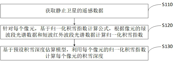
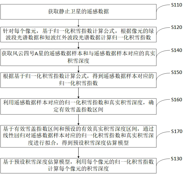
[0041] refer to figure 1 , showing a schematic flowchart of the first method for calculating the snow depth provided by the embodiment of the present invention. The method for calculating the snow depth provided by the embodiment of the present invention includes:
[0042] S110: Acquire remote sensing data of the stationary satellite, wherein the remote sensing data includes the green band spectral data and the short-wave infrared band spectral data of each pixel.
[0043] It is understandable that snow has extremely high visible light (Visible Light) reflectivity and extremely low short-wave infrared (Short Wave Infrared) reflectivity, so in snow-related research, it is often based on the green band spectral data in the image and short-wave infrared (Short Wave Infrared) reflectivity. Infrared spectral data distinguish snow from most cloud types.
[0044] It can also be understood that a geostationary satellite refers to an artificial earth satellite whose orbit is a geostat...
Embodiment 2
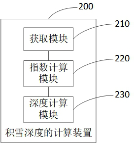
[0101] Corresponding to the method for calculating snow depth provided in Embodiment 1 of the present invention, Embodiment 2 of the present invention provides a device for calculating snow depth. Figure 4 , showing a schematic structural diagram of a device for calculating snow depth provided by an embodiment of the present invention. The device 200 for calculating snow depth provided by an embodiment of the present invention includes:
[0102] an acquisition module 210, configured to acquire remote sensing data of the stationary satellite, wherein the remote sensing data includes the green band spectral data and the short-wave infrared band spectral data of each pixel;
[0103] The index calculation module 220 is configured to, for each pixel, calculate a normalized product according to the green band spectral data and the short-wave infrared band spectral data of the pixel based on a normalized snow cover index calculation formula snow index;
[0104] The depth calculatio...
PUM
 Abstract
Description
Claims
Application Information
 - R&D
- Intellectual Property
- Life Sciences
- Materials
- Tech Scout
- Unparalleled Data Quality
- Higher Quality Content
- 60% Fewer Hallucinations
Browse by: Latest US Patents, China's latest patents, Technical Efficacy Thesaurus, Application Domain, Technology Topic, Popular Technical Reports.
© 2025 PatSnap. All rights reserved.Legal|Privacy policy|Modern Slavery Act Transparency Statement|Sitemap|About US| Contact US: help@patsnap.com


