Sea ice freeboard estimation method and system based on aviation laser altimetry

A laser and aeronautical technology, applied in measuring instruments, measuring devices, mapping and navigation, etc., can solve the problems of underestimation of sea ice freeboard, overestimation of local sea surface high value, indistinguishable inter-ice waterway, etc., to improve reliability. Effect

Active Publication Date: 2022-08-05
WUHAN UNIV
View PDF4 Cites 0 Cited by
  • Summary
  • Abstract
  • Description
  • Claims
  • Application Information

AI Technical Summary

Problems solved by technology

Therefore, it is difficult to effectively distinguish polynyas from Nile ice and gray-white ice by using surface reflectance.
This will lead to an overestimation of the local high value of the sea surface, which in turn leads to an underestimation of the sea ice freeboard

Method used


Image

  • Sea ice freeboard estimation method and system based on aviation laser altimetry

Examples


Embodiment Construction

[0037] The present invention will be described in further detail below with reference to the accompanying drawings and embodiments.

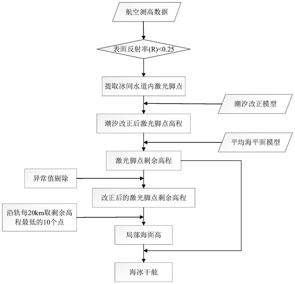
[0038] see figure 1 , a method for estimating sea ice freeboard based on aerial laser altimetry provided by an embodiment of the present invention includes the following steps:

[0039] Step 1, Aerial laser altimetry data processing, including the following sub-steps:

[0040] Step 1.1, extract parameters including longitude, latitude, elevation, track number, surface reflectivity, etc.: The embodiment is based on IceBridge aerial laser altimetry data, taking IceBridge route 20140428_1 as an example, to extract the longitude (lon) and latitude of the laser foot point on the route (lat), elevation (h), surface reflectivity (R), track number (orb), etc.;

[0041] Step 1.2, using the tidal model to perform tidal correction on the laser altimetry data: the embodiment uses the TPX09 tidal model to perform tidal correction on the laser footsteps to ...


PUM


Abstract

The invention provides a north pole sea ice freeboard estimation method and system based on aviation laser altimetry data. The method comprises the steps of processing the aviation laser altimetry data, extracting parameters of laser foot points on a route, carrying out tide correction on the laser altimetry data, and calculating the residual elevation of the laser foot points. According to the surface reflectivity, identifying the inter-ice water channel, and extracting a laser foot point in the inter-ice water channel; calculating the local sea surface height, removing the laser foot points in the abnormal inter-ice water channel according to the large step length, extracting a plurality of points with the minimum residual elevation values of the laser foot points in the inter-ice water channel according to the small step length, and taking the average residual elevation value as the local sea surface height of the section; for the segment without the inter-ice water channel, the local sea surface height is obtained through local sea surface height interpolation of the adjacent segments; and calculating and outputting a sea ice freeboard prediction result by using the residual elevation and the local sea surface height. According to the method, Nile ice and gray ice are effectively removed by using the elevation value of the laser foot point, so that the reliability of a sea ice freeboard estimation result is improved.

Description

technical field [0001] The invention belongs to the field of geodetic surveying and mapping engineering, in particular to a sea ice freeboard estimation method and system based on aerial laser altimetry. Background technique [0002] Sea ice is an important part of the Earth system and plays an important role in mediating the interaction between the atmosphere and ocean in polar regions. Obtaining accurate sea ice parameters is crucial for studying scientific issues related to climate change. Sea ice thickness is one of the most important parameters in the sea ice crowd, and it is also the most difficult to observe. The sea ice freeboard height refers to the height of the sea ice surface relative to the local sea level, and is the basic data for obtaining the thickness and volume of sea ice. Satellite altimetry and aerial altimetry are the main methods for obtaining sea ice freeboard in a wide range. [0003] Compared with satellite altimetry, which can obtain hemispheric-...

Claims


Application Information

Patent Timeline
Patent Type & Authority Applications(China)
IPC IPC(8): G01C5/00G01C15/00G06F30/20G06F119/02
CPCG01C5/00G01C15/00G06F30/20G06F2119/02Y02A90/10
Inventor 张胜凯肖峰朱朝辉李佳星耿通李潇朱本鑫
Owner WUHAN UNIV
Why Eureka
Try Eureka