An electronic map communication device and use based on GPS global position system

A global positioning system and electronic map technology, applied in the field of telecommunications, can solve the problems of long time to determine the location of the crime, long call time, urgent need to know yourself, etc.

Inactive Publication Date: 2007-08-01
吴长松 +1
View PDF5 Cites 0 Cited by
  • Summary
  • Abstract
  • Description
  • Claims
  • Application Information

AI Technical Summary

Problems solved by technology

[0009] The purpose of the present invention is also to provide an emergency alarm method to solve the problems of too long talk time, long dial-up time, and long time for determining the location of the crime in the emergency alarm.
The purpose of the present invention is also to provide a navigation method to solve the problem that people urgently need to know their own position because they get lost in a strange city, field travel or scientific research, or urgently need to know the best route to the destination, etc. question

Method used


Image

  • An electronic map communication device and use based on GPS global position system
  • An electronic map communication device and use based on GPS global position system
  • An electronic map communication device and use based on GPS global position system

Examples


Embodiment 1

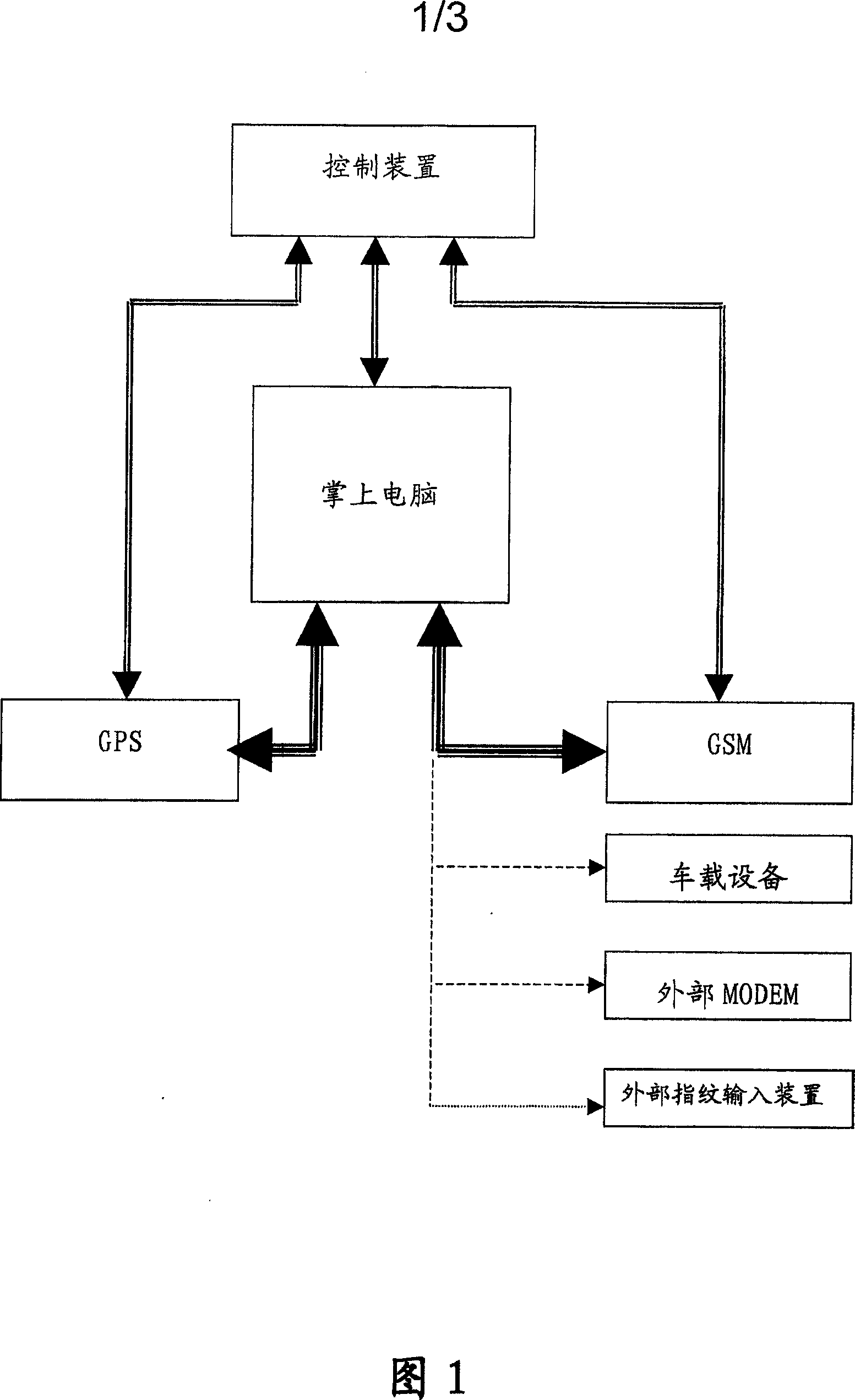
[0074] As shown in Figure 1 and Figure 2, in the implementation of an electronic map communication device based on GPS global positioning system, it includes: a control device, a palmtop computer, a GPS module, and a GSM module; wherein: the palmtop computer is connected with the GPS module, and the palmtop The computer initializes the GPS module, the GPS module transmits data to the handheld computer after initialization, the handheld computer loads the electronic map and receives the data from the GPS module, and the handheld computer displays the position; Initialization, the GSM module transmits data to the handheld computer after initialization; the handheld computer displays an analog keyboard, dials through the analog keyboard to connect to the wireless communication network; the handheld computer displays incoming call information and the analog keyboard, and uses the analog keyboard to select and connect to the wireless communication network; The palmtop computer is co...

Embodiment 2

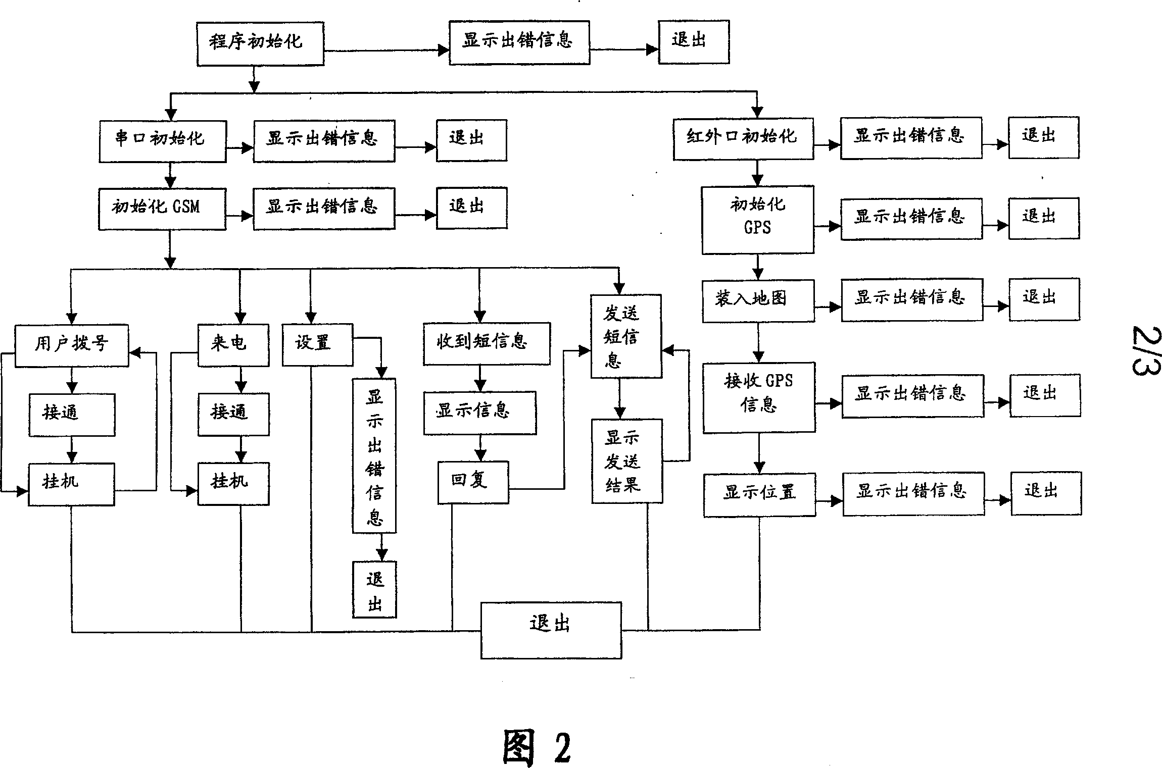
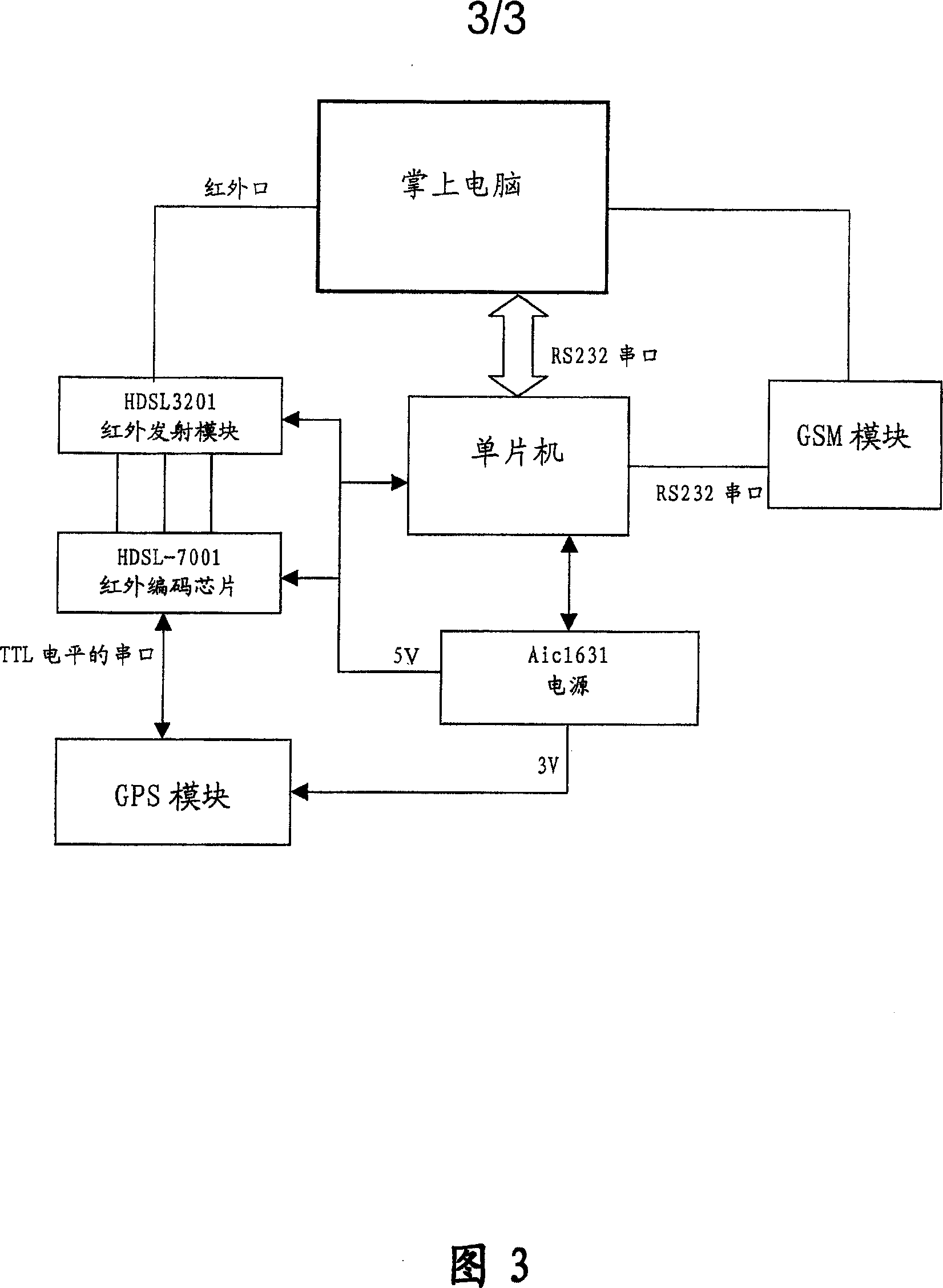
[0077] As shown in Fig. 2 and Fig. 3, in the implementation of a kind of electronic map communication device based on GPS global positioning system, comprise: control device, palmtop computer, GPS module, GSM module; Described control device can be a single-chip microcomputer. Described device can also comprise: infrared emission module HDSL3201, infrared encoding chip HDSL-7001, power supply Aic1631; Wherein: described palmtop computer and GPS module connection can be, palmtop computer is connected with infrared emission module through infrared port, infrared emission The module is connected with the infrared encoding chip, and the infrared encoding chip is connected with the GPS module through the serial port of TTL level; the handheld computer initializes the infrared port; the connection between the handheld computer and the GSM module can be, and the handheld computer is connected with the GSM module through the RS232 serial port The palmtop computer initializes the RS232 ...

Embodiment 3

[0080] As shown in Figure 2 and Figure 3, in the implementation of an emergency alarm method, it includes: a control device, a palm computer, a GPS module, and a GSM module; the control device can be a single-chip microcomputer. Described device can also comprise: infrared emission module HDSL3201, infrared encoding chip HDSL-7001, power supply Aic1631; Wherein: described palmtop computer and GPS module connection can be, palmtop computer is connected with infrared emission module through infrared port, infrared emission The module is connected with the infrared encoding chip, and the infrared encoding chip is connected with the GPS module through the serial port of TTL level; the handheld computer initializes the infrared port; the connection between the handheld computer and the GSM module can be, and the handheld computer is connected with the GSM module through the RS232 serial port The palmtop computer initializes the RS232 serial port; the connection between the control d...


PUM


Abstract

An electronic map communication device based on GPS Global Position System, which includes: controlling means, a palmtop computer, GPS module, GSM module; whichin the Palmtop computer connects to the GPS module, and initializes the GPS, the palmtop computer is provided with an electronic map and receives the data sent from the GPS module; The palmtop computer connects to the GSM module, initializes the GSM module, the palmtop computer shows the simulation keyboard and dials to put through the radio communication network by the simulation keyboard; The palmtop computer displays call information and the simulation keyboard and chooses to put through the radio communication network by the simulation keyboard; the control device connects to the palmtop computer, outputs the control signals to the palmtop computer and receives the signals from the palmtop compter; the control device connects to the GPS module, outputs control signal to the GPS module and receives the signals that were sent from the GPS module; the control device connects to the GSM module and outputs control signals to the GSM module and receives the signals that were sent from GSM module.

Description

technical field [0001] The invention relates to the field of electric communication, in particular to an electronic map communication device based on the GPS global positioning system and its application. Background technique [0002] With the rapid development of communication technology, a system that combines GPS global positioning system and electronic map has appeared, and its purpose is to provide users with satellite navigation. At present, most of GPS is realized by hardware, and its expensive price has caused difficulties in application promotion. However, most of the current electronic maps are re-digitized maps that have been published, and their products are one-dimensional. Therefore, the accuracy of this electronic map is not enough. When accurate navigation is required, this electronic map cannot meet the requirements at all. Although foreign GPS products with expandable map modules have been used, their high prices and the particularity of the country's map ...

Claims


Application Information

Patent Timeline
Patent Type & Authority Patents(China)
IPC IPC(8): H04Q7/34G01S5/14G09B29/10
CPCG09B29/10
Inventor 吴长松杨光进
Owner 吴长松
Why Eureka
Try Eureka