Receiver for assisting satellite in navigation with foundation facilities, and method therefor

A technology of satellite navigation and satellite navigation system, applied in the field of low-priced field equipment, can solve the problem of high hardware cost, and achieve the effect of improving sensitivity and shortening the time of first positioning

Inactive Publication Date: 2002-10-09
FURUNO ELECTRIC CO LTD +1
View PDF2 Cites 27 Cited by
  • Summary
  • Abstract
  • Description
  • Claims
  • Application Information

AI Technical Summary

Problems solved by technology

These factors result in high hardware costs

Method used


Image

  • Receiver for assisting satellite in navigation with foundation facilities, and method therefor
  • Receiver for assisting satellite in navigation with foundation facilities, and method therefor
  • Receiver for assisting satellite in navigation with foundation facilities, and method therefor

Examples


Embodiment Construction

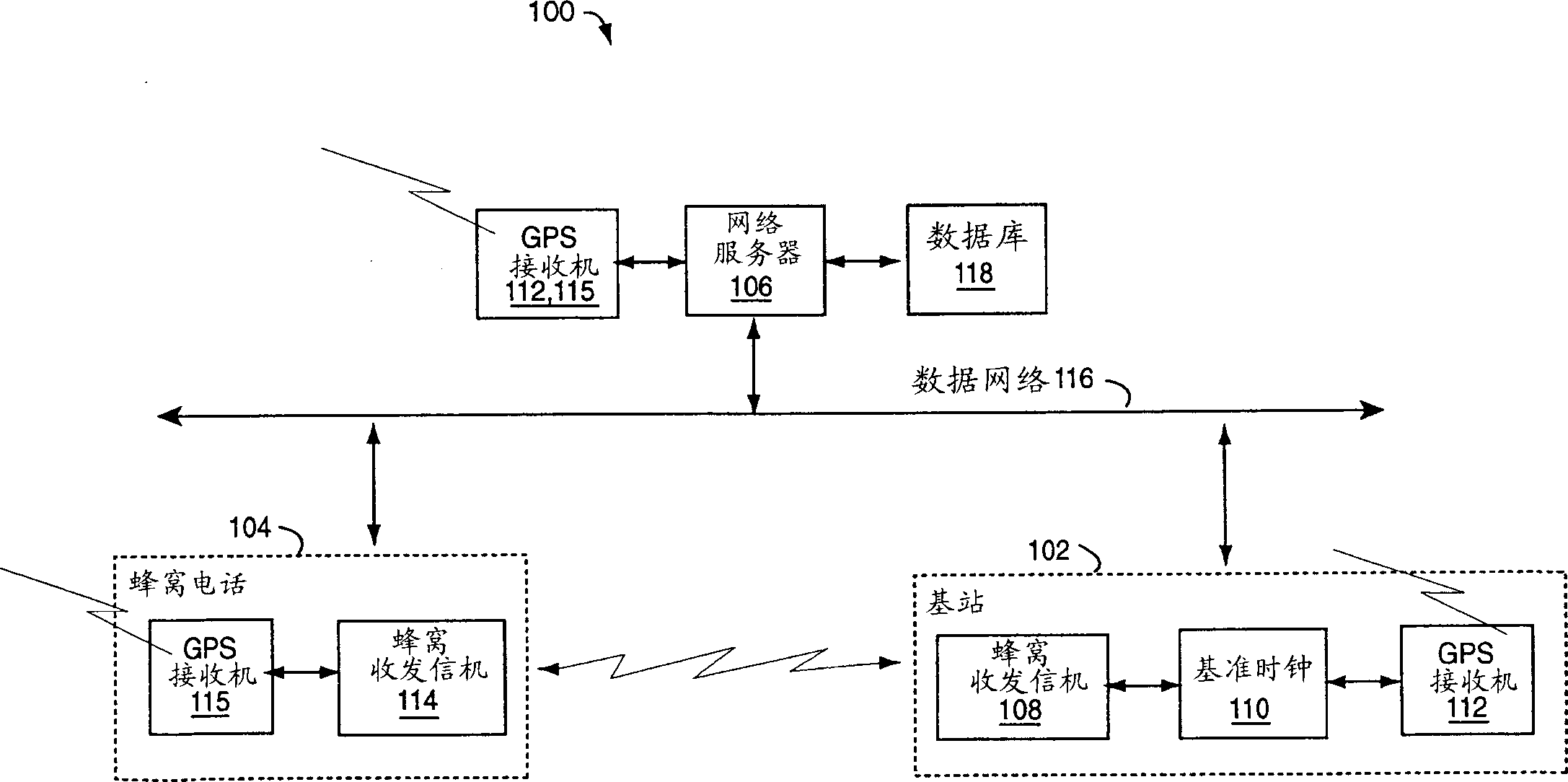
[0029] Three hardware-based measurements can be used to synchronize local clocks in two independent systems, such as (1) time difference, (2) frequency difference, and (3) temperature-frequency model of the crystal. Any or all of these three measurements can be used to synchronize the clocks. In measurable timeDiff, if the time difference of time events of two different time sources is known, an event time of one time source can be used to calculate the event time of another time source. In a freqDiff, if the frequency difference between two clocks is known, finding the frequency of one can be used to predict the frequency of the other. A temperature-frequency correction model can be used to predict the frequency of the local GPS clock by measuring the temperature of the crystal during a measurable tempMeas (temperature measurement). If one of the time sources is a GPS receiver, the other clocks can be related to this GPS time. This makes it possible to synchronize the time ...


PUM


Abstract

A navigation system includes a cellular phone, a base station and a network server. Each of them is paired with a GPS receiver. Cell phone GPS receivers are aided by information received from base stations and web servers, reducing the uncertainty of satellite searches. Time difference and/or frequency difference measurements are used with the collected data, and the cell phone and its GPS receiver assume they are precise time and frequency. The correction information is used to post-process the velocity solution computed by the cell phone to obtain a more accurate solution for the system.

Description

technical field [0001] The present invention relates to satellite navigation receivers and systems, and more particularly to such a low-cost field device that is assisted by network-provided information about precise time and frequency, thereby shortening the time-to-first-fix first-fix), improve accuracy, and reduce manufacturing costs. Background technique [0002] US Patent Application Serial No. 09 / 687,044, filed October 11, 2000, and entitled "Satellite Navigation Receiver and Method" is hereby incorporated by reference. [0003] A Global Positioning System (GPS) receiver uses signals received from typically three or more earth-orbiting satellites to determine navigational data such as position and velocity. GPS signals, which can be received worldwide at no cost, are now used more and more often to determine a car's location to an accuracy of one block or better. Dual carrier frequency GPS receivers typically track a pair of radio carriers L1 and L2 associated with t...

Claims


Application Information

Patent Timeline
Patent Type & Authority Applications(China)
IPC IPC(8): G01C21/00G01S1/00G01S5/10G01S5/14G01S19/06G01S19/25G08G1/0969H04W64/00
CPCG01C21/206G01S5/10G01S19/05G01S19/235G01S19/256G01S19/29G01S19/41
Inventor P·W·麦博尼A·N·沃
Owner FURUNO ELECTRIC CO LTD
Why Eureka
Try Eureka