Method for estimating city road network traffic flow state

An urban road network and state estimation technology, which is applied in the field of intelligent transportation research, can solve the problems of high data error rate, lack of data acquisition, low reliability, etc., and achieves the effect of fast calculation speed, simple calculation and high reliability.

Inactive Publication Date: 2005-12-14
SHANGHAI JIAO TONG UNIV
View PDF0 Cites 54 Cited by
  • Summary
  • Abstract
  • Description
  • Claims
  • Application Information

AI Technical Summary

Problems solved by technology

Martin L. Hazclton effectively considered and modeled the problem of high error rate and low reliability of road detection ring data, and the results are gratifying, but his research was carried out on the highway, which is only applicable to the situation where the traffic flow is a continuous flow , and the traffic flow in the city is discontinuous flow, which is not suitable for the traffic flow state estimation of the urban road network
Using detection ring data to estimate traffic flow in urban road networks has high requirements for urban infrastructure. In many cities, enough required data is often not obtained, and the problem of high error rate cannot be effectively solved.

Method used


Image

  • Method for estimating city road network traffic flow state
  • Method for estimating city road network traffic flow state
  • Method for estimating city road network traffic flow state

Examples


Embodiment Construction

[0026] In order to better explain the technical solution of the present invention, a further detailed description will be made below in conjunction with the accompanying drawings and embodiments.

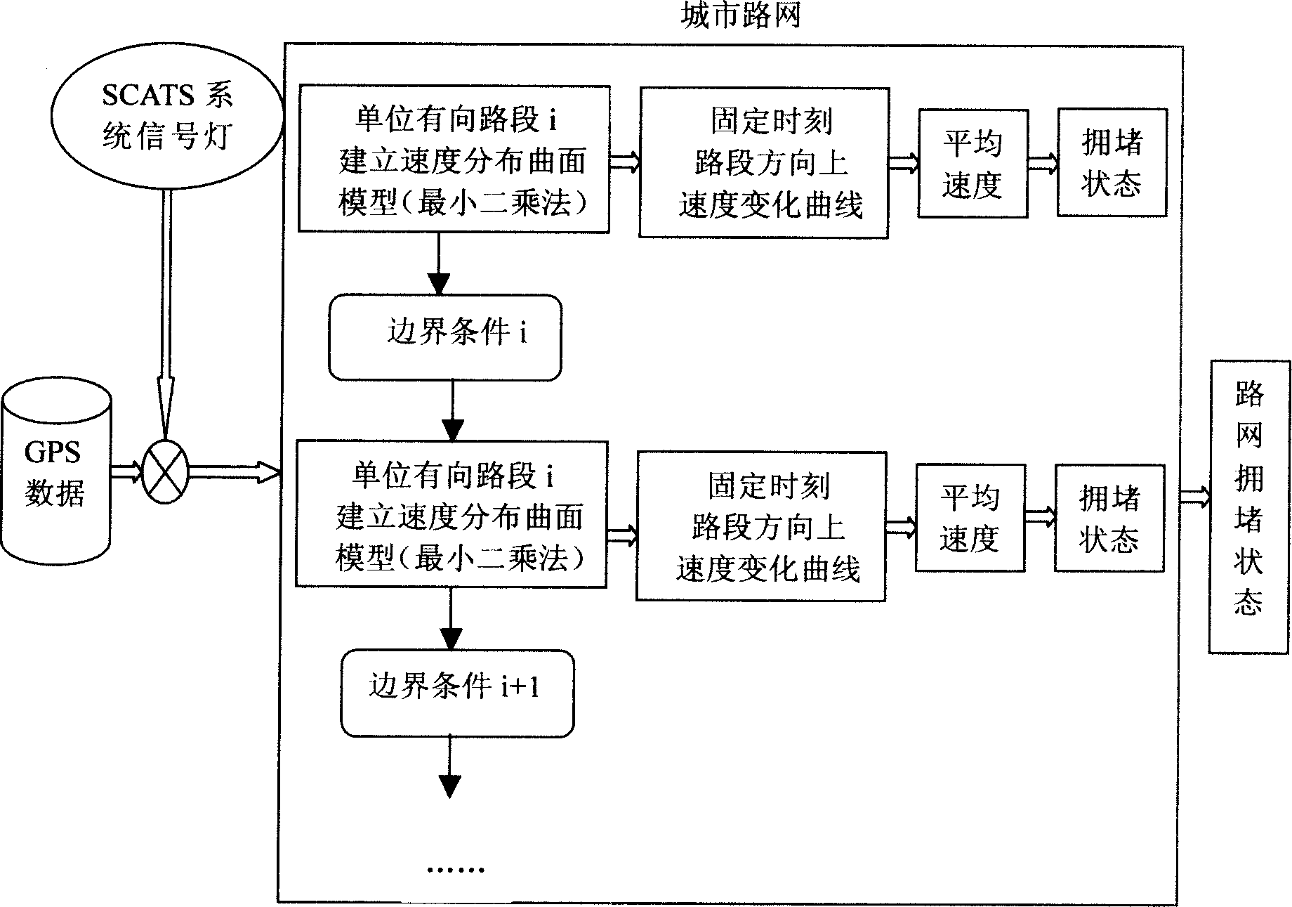
[0027] The input data required by the present invention is vehicle satellite positioning data of the GPS system, which provides dynamic traffic detection information including sampling vehicle number, time, position, speed, running direction, and vehicle status. Auxiliary information is the status information of the signal lamp provided by the SCATS traffic adaptive control system, including the phase of the signal lamp and the phase conversion cycle.

[0028] The present invention adopts figure 1 The specific implementation steps of the urban road network traffic flow state estimation scheme shown are as follows:

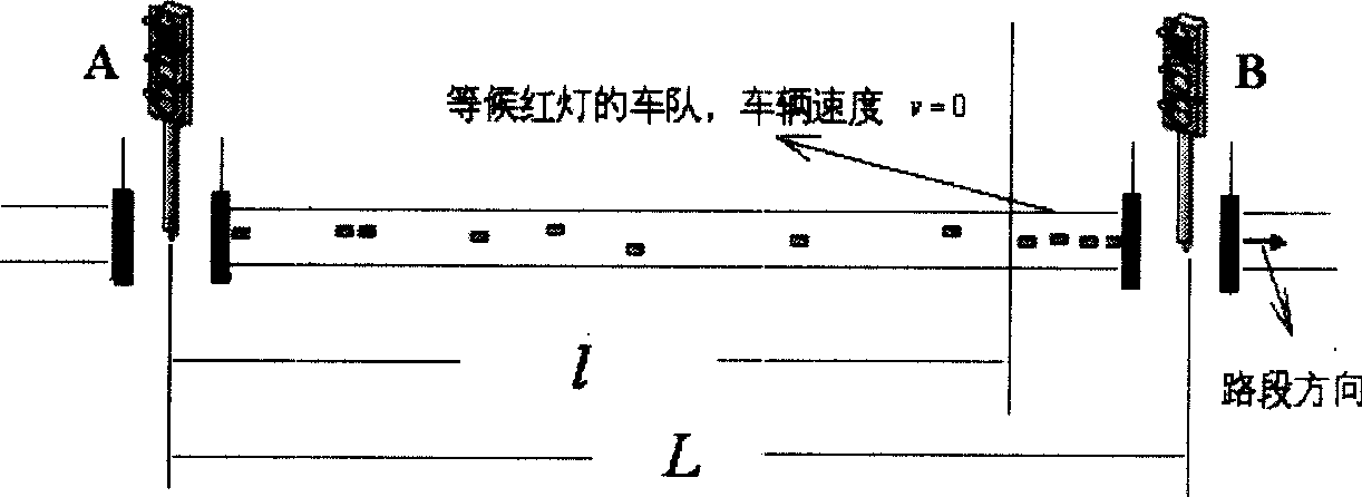
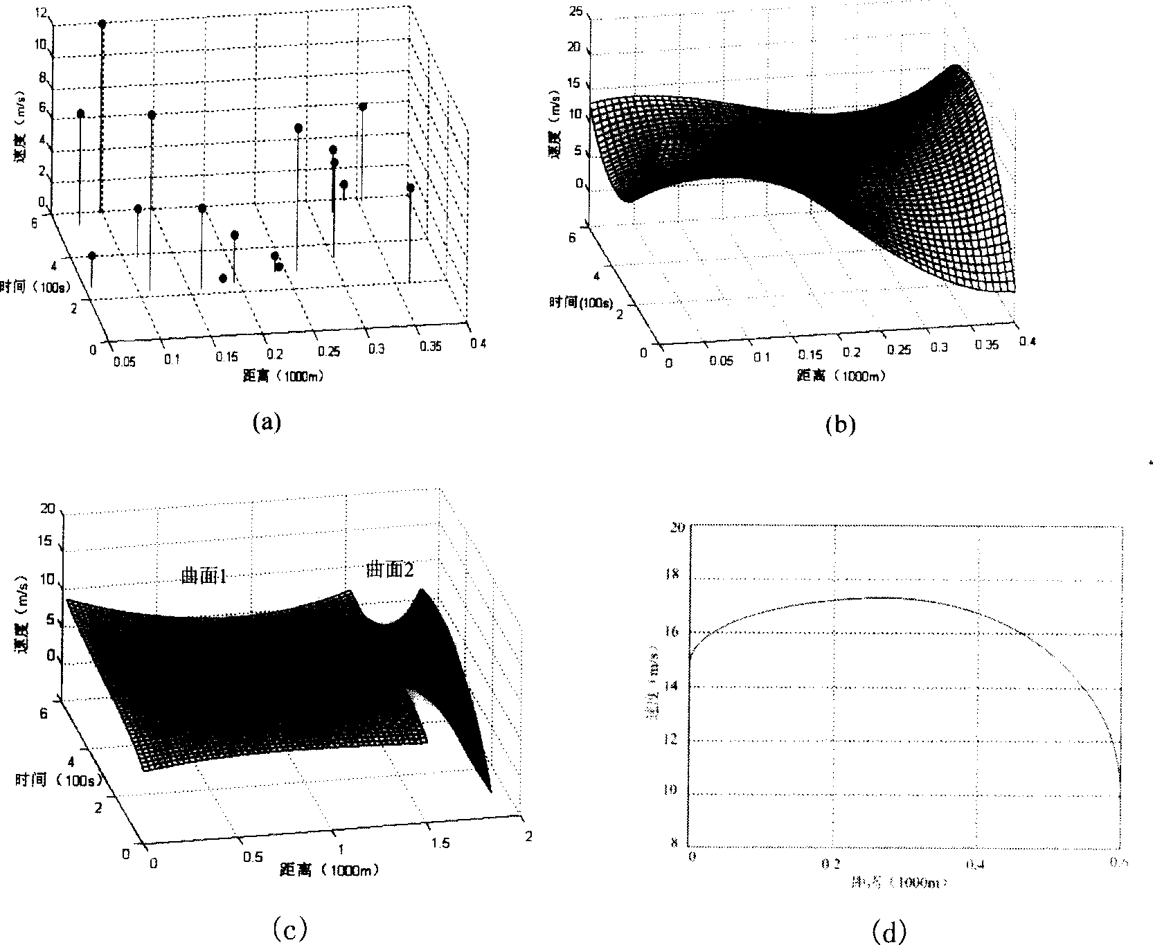
[0029] 1. Data preprocessing for GPS data

[0030] The on-board GPS data points that can provide information including distance, time, and speed are regarded as sampli...


PUM


Abstract

The city road net traffic flow state estimating method is based on vehicular GPS data combined with SCATS provided traffic signal state information. The present invention establishes city road net traffic flow state model by adopting unit oriented road sections as targets and through least-square method fitting in the three-dimensional space of distance, time and speed. Through the conversion from curved surface in the three-dimensional space to the curve in the two-dimensional space, the average speeds in various oriented road sections of the city road net in fixed time are obtained, and the current traffic flow jamming state is analyzed and estimated with speed as index. The traffic flow state estimation is completed through establishing the traffic flow state model for each of the unit oriented road sections between two signal lamps and connecting the curve surface models of adjacent equidirectional road sections.

Description

technical field [0001] The invention relates to a method for estimating the traffic flow state of an urban road network, which is used for estimating the road congestion state in an advanced urban traffic management system and belongs to the field of intelligent traffic research. Background technique [0002] With the rapid development of social economy, on the one hand, the demand for traffic has increased greatly, while the growth of roads has gradually reached its limit, which further intensifies the contradiction between traffic demand and supply; on the other hand, the rapid progress of information technology has brought comprehensive solutions to traffic problems. opportunity. It is against this background that the advanced traffic information management system (ATIMS) has received extensive attention before other systems of the intelligent transportation system (ITS), and has developed rapidly in countries all over the world, and has been applied to dynamic route plan...

Claims


Application Information

Patent Timeline
Patent Type & Authority Applications(China)
IPC IPC(8): G08G1/00
Inventor 喻泉盛志杰刘允才
Owner SHANGHAI JIAO TONG UNIV
Why Eureka
Try Eureka