Method for obtaining average speed of city rode traffic low region

A technology of average speed and urban road network, applied in the field of intelligent transportation, it can solve the problems of difficulty in re-laying induction coils, low precision, and large impact on service life, and achieve great economic and social effects, strong real-time performance, and efficiency. Good results

Inactive Publication Date: 2005-12-21
SHANGHAI JIAO TONG UNIV
View PDF0 Cites 41 Cited by
  • Summary
  • Abstract
  • Description
  • Claims
  • Application Information

AI Technical Summary

Problems solved by technology

These studies have achieved success in some aspects and have practical value, but there are limitations in the calculation of urban road network traffic flow speed: 1) The induction coil monitor can obtain a variety of traffic flow parameters, and the speed estimation is an indirect calculation result , the accuracy is not high, and the calculation is complicated; it is difficult to re-lay the induction coil, the cost of adding equipment is high, and the service life is greatly affected by human damage factors
2) Video detection requires high hardware equipment and is greatly affected by weather
3) There is a problem that the detection range is affected by the hardware laying conditions, and only the main roads in the city can be detected
The real-time calculation of the vehicle's precise positioning and driving track's average speed in the direct application interval is calculated from GPS data, which is simple and practical. There are no specific research results and practical application systems in China at present.

Method used


Image

  • Method for obtaining average speed of city rode traffic low region
  • Method for obtaining average speed of city rode traffic low region
  • Method for obtaining average speed of city rode traffic low region

Examples


Embodiment Construction

[0027] The technical solutions of the present invention will be further described below in conjunction with the accompanying drawings and specific embodiments.

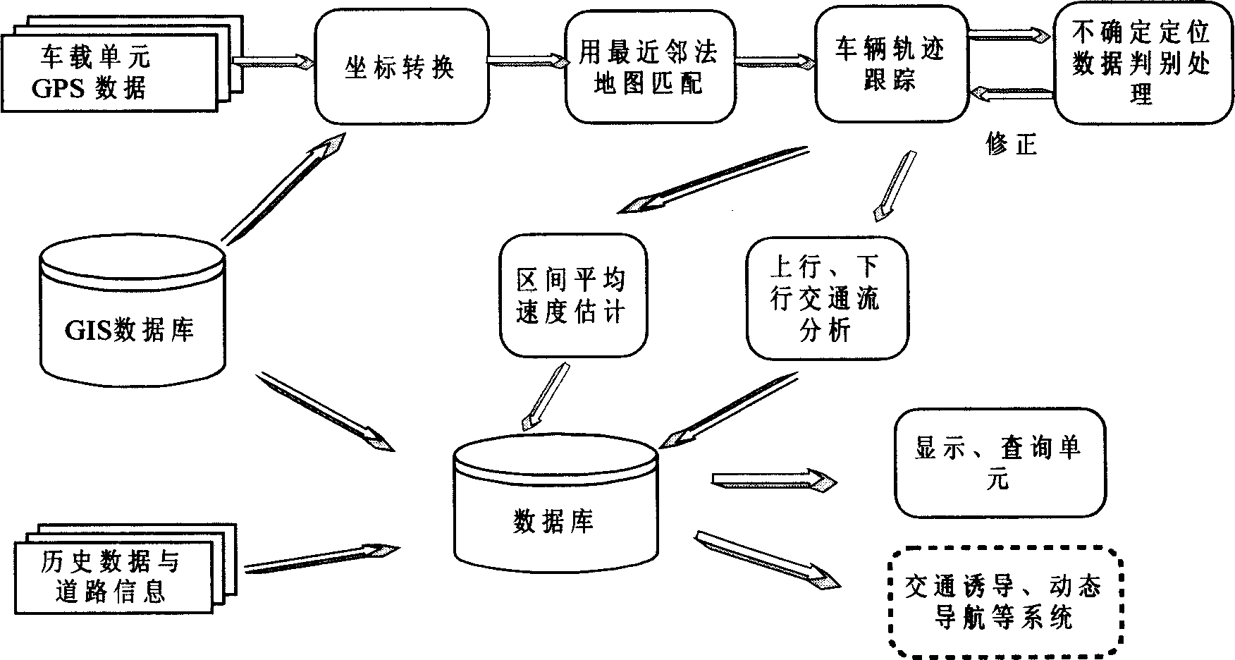
[0028] The embodiment takes Shanghai GIS data and the GPS data of about 3,000 taxis provided by Volkswagen Taxi Company as an example data processing, and the processing cycle T is 10 minutes. The cycle selection mainly takes into account the periodic changes of traffic lights and traffic behavior. The GPS positioning data interval of the taxi data in actual travel is 20 seconds, the data is relatively sparse, and the continuous data may span one or more road sections, without the direction data provided by the gyroscope, the DR algorithm cannot be used; the road network in the city The spacing is small, the topology is complex, and the information is diverse.

[0029] The present invention adopts such as figure 1The processing flow shown uses the real-time GPS vehicle data and GIS data as input data, uniformly appli...


PUM


Abstract

Based on considering each error existed in data received by GPS, features of roads in GIS, and artificial factors of drivers synthetically, the invention uses a method of nearest neighbor to obtain preliminary matched result in map. Accurate positioning location of vehicle is obtained from following steps: through A* algorithm finds out shortcut between two points; recovering run locus of vehicle in real time and intelligence; considering relation between fore and after as well as load condition of data of vehicle, the method carries out modification for doubtful matching points and formed run locus of vehicle. Finally, average up going speed, down going speed and average speed in mixed-use area are calculated from run locus of vehicle, and displayed on digital map. Features are: high real time and precision, without need of angular transducer etc. hardware facilities so as to lower system cost and complexity of designing system, and raising system performance

Description

technical field [0001] The invention relates to a method for obtaining the average speed of the urban road network traffic flow section, which is used to obtain the precise positioning and driving track of the vehicle from the global positioning system (GPS) data in real time and dynamically, and to carry out urban traffic in combination with the geographic information system (GIS) The invention relates to the calculation of the average speed of the two-way section of the flow, which belongs to the technical field of intelligent transportation. Background technique [0002] Intelligent Transportation System (ITS) is an ideal solution to many transportation problems brought about by economic development, and it represents the development trend of transportation system. With the maturity of micro-embedded technology, GPS satellite positioning technology, communication technology and geographic information system (GIS), the development and application of urban traffic informati...

Claims


Application Information

Patent Timeline
Patent Type & Authority Applications(China)
IPC IPC(8): G08G1/01
Inventor 吴卉盛志杰刘允才
Owner SHANGHAI JIAO TONG UNIV
Why Eureka
Try Eureka