Multi-parameter dimension-reducing oil-gas-water-layer identifying method
An identification method, multi-parameter technology, applied in water resources assessment, climate sustainability, electrical/magnetic detection for logging records, etc. and other problems, to achieve the effect of high plate accuracy and discriminating coincidence rate, improving construction success rate and improving economic benefits
- Summary
- Abstract
- Description
- Claims
- Application Information
AI Technical Summary
Problems solved by technology
Method used
Image
Examples
Embodiment 1
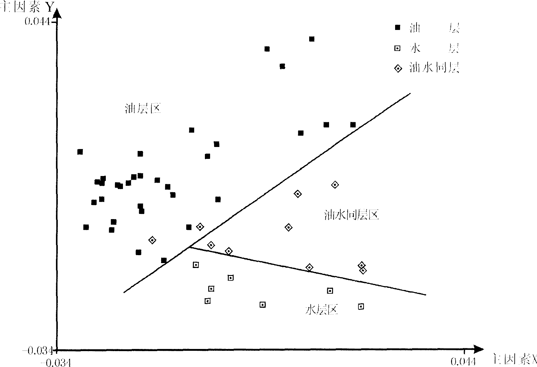
[0061] ① Investigate and study the geological conditions of the reservoir, collect oil test, test production or oil production data of the reservoir.
[0062] The XZ structure is located in the XZ nose structure in the south of the Qijia-Gulong sag in the central depression area of the Songliao Basin, and the main target layer is the Putaohua oil layer of the first member of the Yaojia Formation of the Lower Cretaceous system. The main body of the top surface of the Putaohua oil layer is a wide and gentle nose-shaped structure dipping from northeast to southwest, and the southwest is the transitional saddle of the XZ nose-shaped structure dipping to the northeast. The overall structural form is high in the east and low in the west, high in the north and low in the south, with two nose-shaped structures and two synclines distributed alternately. Cut by faults, it has the structural characteristics of east-west zoning, and developed some quaternary structures dominated by faul...
Embodiment 2
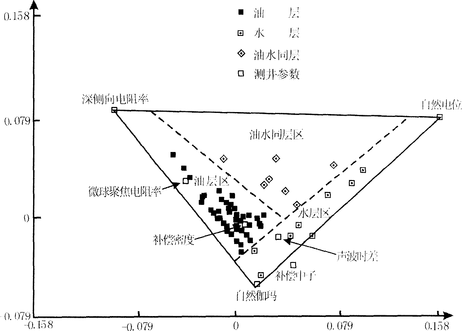
[0079] ① Investigate and study the geological conditions of the reservoir, and obtain the oil test, test production or oil production data of the reservoir.
[0080] The Bycg reservoir structure is located in the west of the central depression in the northern part of the Songliao Basin, across two secondary structural belts, the Longhupao-Da'an Terrace and the Qijia-Gulong Sag. The main target layer for exploration is the FY oil layer in the upper part of Quan 4 Member and Quan 3 Member of Lower Cretaceous Cretaceous.
[0081] From the structural map of the top surface of the F oil layer, this area is located in the west of the central depression in the northern Songliao Basin. There are two secondary structural belts in the middle part of Kualonghupao-Da'an Terrace and Qijia-Gulong Sag. In general, it is a paleo-monocline that is uplifted westward by the Talaha syncline, with well-developed faults, and three groups of north-north-east fault zones play a leading role. From ea...
PUM
| Property | Measurement | Unit |
|---|---|---|
| Thickness | aaaaa | aaaaa |
| Thickness | aaaaa | aaaaa |
| Permeability | aaaaa | aaaaa |
Abstract
Description
Claims
Application Information
 - R&D
- Intellectual Property
- Life Sciences
- Materials
- Tech Scout
- Unparalleled Data Quality
- Higher Quality Content
- 60% Fewer Hallucinations
Browse by: Latest US Patents, China's latest patents, Technical Efficacy Thesaurus, Application Domain, Technology Topic, Popular Technical Reports.
© 2025 PatSnap. All rights reserved.Legal|Privacy policy|Modern Slavery Act Transparency Statement|Sitemap|About US| Contact US: help@patsnap.com


