Interstellar cruising self-nevigation method based on multi-star road sign

An autonomous navigation, multi-celestial body technology, applied in the direction of integrated navigator, etc., can solve the problems of complicated navigation process, difficult operation, low precision, etc.

Inactive Publication Date: 2006-10-25
HARBIN INST OF TECH
View PDF0 Cites 18 Cited by
  • Summary
  • Abstract
  • Description
  • Claims
  • Application Information

AI Technical Summary

Problems solved by technology

[0003] The purpose of the present invention is to provide a self-navigation method for interstellar cruise based on multi-celestial body landmarks to solve the problems of complex navigation process, low precision and difficult operation in the existing optical navigation method

Method used


Image

  • Interstellar cruising self-nevigation method based on multi-star road sign
  • Interstellar cruising self-nevigation method based on multi-star road sign
  • Interstellar cruising self-nevigation method based on multi-star road sign

Examples


specific Embodiment approach 1

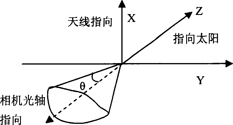
[0074] Specific implementation mode one: (see Figure 1 ~ Figure 3 ) The steps of this embodiment are as follows:

[0075] First, the list of asteroids for planning and navigation:

[0076] 1) Navigation star selection criteria,

[0077] selection criteria

scope

distance from aircraft

0~1000000km

Relative speed to the aircraft

0~7km / s

absolute magnitude

0~12

sun angle

±40 degrees

[0078] 2) Planning the asteroid list Step 1: You can get the asteroid list from the JPL laboratory in the United States, including the asteroid's ephemeris, stars and other physical characteristics. The current position and velocity of the asteroid are obtained by using the two-body orbit calculation method. The distance and relative velocity from the spacecraft can be obtained from the nominal orbit and the asteroid's ephemeris.

[0079] 3) The second step of planning the asteroid list: the aircraft is oriented to the sun, and t...


PUM


Abstract

The invention relates to the space cruising autonomous navigation method based on plural globe route sign. It includes the following steps: programming the navigation using minor planet table, processing navigation minor planet image, and determine the autonomous path. The center of figure of plural minor planet determines the path of craft. The error of craft path is very low. The location error could be closed to 100Km and the speed error could be bellow 0.3m/s. It could satisfy the path accuracy request of the detector.

Description

technical field [0001] The invention relates to an autonomous orbit determination method in deep space exploration interstellar cruising. Background technique [0002] Autonomous navigation technology for deep space exploration is an important technology in the development of aerospace science and technology. Its fundamental purpose is to realize the autonomy of deep space exploration orbit determination, reduce operational complexity and reduce mission costs. Especially in the stage of interstellar cruising, autonomous navigation technology is particularly important. Autonomous navigation can be divided into three categories according to the method of obtaining information: 1) Inertial navigation: continuously integrate the measured acceleration or velocity with respect to time to obtain position information; 2) Celestial navigation / GPS: obtain position information directly from measurement information; 3) Optical navigation / radar graphic matching navigation: process measu...

Claims


Application Information

Patent Timeline
Patent Type & Authority Applications(China)
IPC IPC(8): G01C21/24
Inventor 崔祜涛崔平远刘宇飞张泽旭徐瑞史雪岩
Owner HARBIN INST OF TECH
Why Eureka
Try Eureka