Video data and GIS mapping for traffic monitoring, event detection and change prediction

a technology of which is applied in the field of video data and gis mapping for traffic monitoring, event detection and change prediction, can solve the problems of high cost, severe system constraints, and hampered systems of today's systems, and achieve the effect of reducing the amount of information and low bandwidth

Inactive Publication Date: 2019-03-05
ECHELON CORP
View PDF43 Cites 5 Cited by
  • Summary
  • Abstract
  • Description
  • Claims
  • Application Information

AI Technical Summary

Benefits of technology

[0021]In accordance with an example embodiment of the invention, a plurality of video cameras located at the at least one video unit, configured to analyze and combine multiple views of a same event and only send a reduced amount of information to the central controller, the at least one video unit, configured to prepare a low bandwidth event message representing the reduced amount of information.

Problems solved by technology

But these systems are severely constrained by the massive amounts of monitoring data needed for a complete picture of traffic activity.
Today's systems are also hobbled by energy limitations, high costs, inability to effectively search video, inability to correlate multiple data inputs and the limiting reality of constrained multi-hop communications in sensor network deployments.
Finally, the biggest problem of all is the inability of these systems to accurately replay traffic events or provide insight into future behavior as environment factors are changed, such as the weather, timing of stop lights, restricting vehicle sizes or widening the road.
The ongoing monitoring problem is the appetite for information is always growing, which is driving technology to evolve from simple scalar traffic counting to more complex traffic classification technology.
But the application of AI at the edge of the network in a distributed IoT sensor based environment is new and presents substantial challenges.
The key problem is to mine the information embedded in the video data where it is captured and to monitor for, and detect events which are programmed into the system, often remotely.
But it is difficult to form a comprehensive understanding of an environment based on simple scalar information.
But simple compression is not enough for the upcoming flood of future data.
Increasingly, new applications cannot be supported by typical scalar sensor networks because they require vast amounts of information which can only be obtained from an image or video.
Scalar data is insufficient for many important applications such as GIS, video surveillance, traffic monitoring and the combination of GIS and traffic monitoring information.
Clearly, the scalar approach of counting the events such as the passage of individual cars is not enough.
In addition, simple scalar data collection will not provide enough information to allow the accurate replaying of traffic activity with all the environment nuances for an end user.
Due to the lack of flexible sensors, energy requirements, network connectivity and video platforms, there has been little progress on controlling a distributed system of IoT video sensors.

Method used


Image

  • Video data and GIS mapping for traffic monitoring, event detection and change prediction
  • Video data and GIS mapping for traffic monitoring, event detection and change prediction
  • Video data and GIS mapping for traffic monitoring, event detection and change prediction

Examples


Embodiment Construction

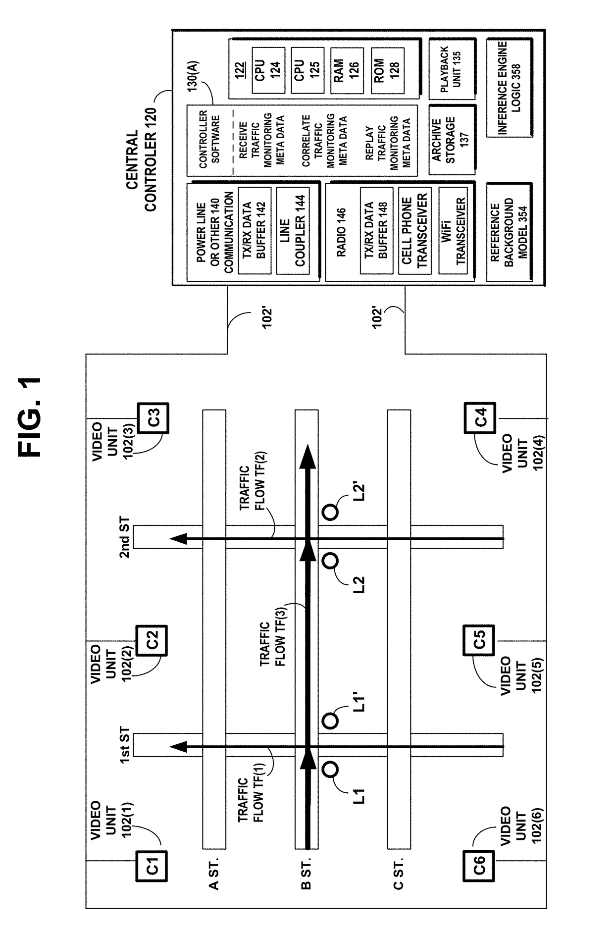
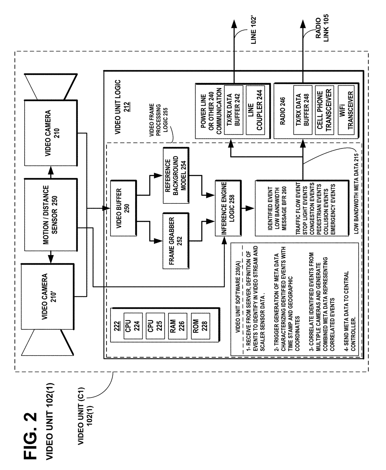
[0037]Example embodiments of the invention solve the problem of mining information embedded in video data representing events to be monitored, at the location where the video data has captured a dynamically changing scene, transmitting the mined information as low bandwidth meta data to a central controller, and constructing representations of the monitored events at the server, which may be replayed to analyze or redesign the location.

[0038]FIG. 1 illustrates an example embodiment of the invention, of a distributed system for traffic monitoring and event detection. The system includes a plurality of video units 102(1) C1, 102(2) C2, 102(3) C3, 102(4) C4, 102(5) C5, and 102(6) C6 located within viewing distance of at least one thoroughfare to be monitored. The thoroughfares shown are the north-south roadways of 1st Street and 2nd Street, and the east-west roadways of A Street, B Street, and C Street. The system also includes a central controller 120 configured to correlate the traff...


PUM


Abstract

A distributed system for traffic monitoring and event detection includes a plurality of video units within viewing distance of a thoroughfare to be monitored. Each video unit processes a video stream while monitoring events at the thoroughfare, identifies and analyzes events, encodes traffic meta data characterizing the analysis, and transmits the meta data to a central controller. The central controller stores a geographic map representing the thoroughfare, correlates the meta data received from the video units, and forms a composite representation of the geographic map and the correlated meta data. The central controller replays previously stored composite representations of the geographic map and the correlated meta data, which were monitored under mutually different event conditions. The central controller is also configured to allow changes to previously stored composite representations of the geographic map and to the correlated meta data for the purpose of understanding the impact of change.

Description

FIELD OF THE INVENTION[0001]The invention disclosed broadly relates to capturing traffic activity, and more particularly relates to employing traffic monitoring and event detection data to drive activity replays or simulations over Geographic Information System (GIS) maps for improved traffic behavior insight and the ability to understand the impact of changes.BACKGROUND OF THE INVENTION[0002]The ability to monitor traffic is important for many business and government reasons. One especially important reason is to acquire underlying data necessary to understand human behavior when driving vehicles and the relationships between drivers and between drivers and the environment and both. The ultimate aim of data collection is allow analysis via replays or utilize other understanding approaches that enable subsequent improvements resulting in smoothing the flow of goods and services, expedite emergency vehicles and, in general, improve the quality of human life. The ability to monitor fo...

Claims


Application Information

Patent Timeline
Patent Type & Authority Patents(United States)
IPC IPC(8): G08G1/01G08G1/08H04W4/80H04W4/70G08G1/095G08G1/048G08G1/04H04W64/00H04W4/00H04L29/08H04W84/04H04W84/12
CPCG08G1/0145G06F16/444G08G1/0129G08G1/0133G08G1/04G08G1/048G08G1/08G08G1/095H04L67/12H04L67/22H04W4/70H04W4/80H04W64/006G06F16/29G06F16/738G08G1/0116H04W84/042H04W84/12H04L67/535
Inventor MODI, SOHRABSINGH, SHALENDER
Owner ECHELON CORP
Why Eureka
Try Eureka