Unified geographic database and method of creating, maintaining and using the same

a geographic database and database technology, applied in the field of unified geographic database, can solve the problems of disparate sources continuously in flux, no universal clearinghouse method or system of acquiring and distributing location-based basic, enhanced and/or real-time information, etc., and achieve the effect of increasing the resolution

Inactive Publication Date: 2005-12-22
WGRS LICENSING
View PDF1 Cites 144 Cited by
  • Summary
  • Abstract
  • Description
  • Claims
  • Application Information

AI Technical Summary

Benefits of technology

[0019]FIG. 2 shows a single cell of FIG. 1 with hierarchical gridding to increase the addressing resolution.

Problems solved by technology

Notwithstanding the power of the Internet as a means of gathering and disseminating information, there is currently no universal “clearinghouse” method or system of acquiring and distributing location-based basic, enhanced and / or real-time information about the millions of real-world businesses and other addresses in the world.
These disparate sources are continually in flux, but on different schedules, and often materially inaccurate in one way or another.
No single source exists to provide or link to correct, up-to-date information regarding all businesses and other entities.
Further, it is impossible currently to synthesize the many sources of information on a timely basis, and also to distribute it to the myriad systems where it is needed and used.
Still, Yellow Pages publishers, whether via physical books or the Internet, do not possess listings of all locations, e.g. city parks.
Nevertheless, it is clearly not the LEC's primary business to create and distribute address and location information.
In addition, many businesses now use competitive local exchange carriers (a “CLEC”), so there is not one clear source for local business telephone listings.
Some individuals, and a few businesses, are foregoing wireline telephone service entirely, which means that the addresses may never be captured in the LEC or CLEC system.
Furthermore, LECs and CLECs typically only obtain basic information such as name, street address and telephone number.
These street addresses may or may not be geocoded (through various geocoding engines, with uneven results), so that their actual position in space, and on maps is unreliable.
Enhanced information is typically obtained by Yellow Page providers, but this information rarely makes it into any type of universal, location-based database designed to provide immediate access to all users of Internet-enabled devices and services.
Finally, the LEC and CLEC information is not updated quickly or, with changes in carriers, even regularly: Yellow-Page books are typically printed annually, and, thus, provide an incredibly inefficient method of address and location handling that ultimately takes little advantage of the power of the Internet.
Accordingly, large amounts of resources, including time, personnel and money, are currently being wasted on (1) multiple solicitations of the same information from the same businesses and (2) storage and distribution of that information.

Method used


Image

  • Unified geographic database and method of creating, maintaining and using the same
  • Unified geographic database and method of creating, maintaining and using the same
  • Unified geographic database and method of creating, maintaining and using the same

Examples


example 1

A. EXAMPLE 1

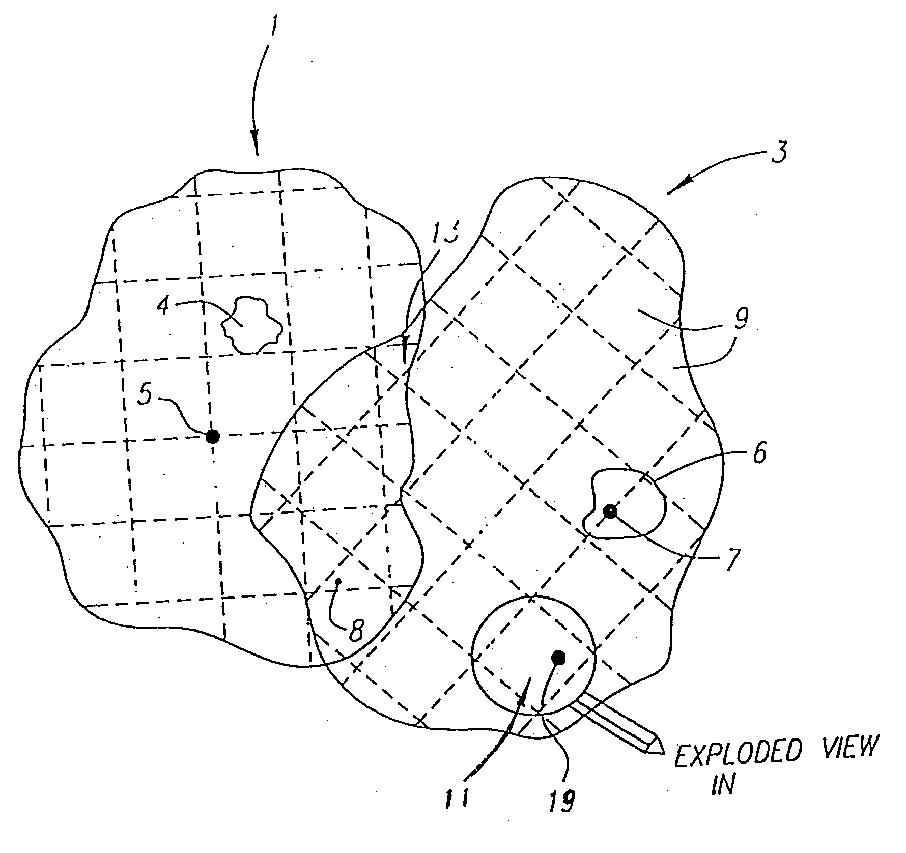
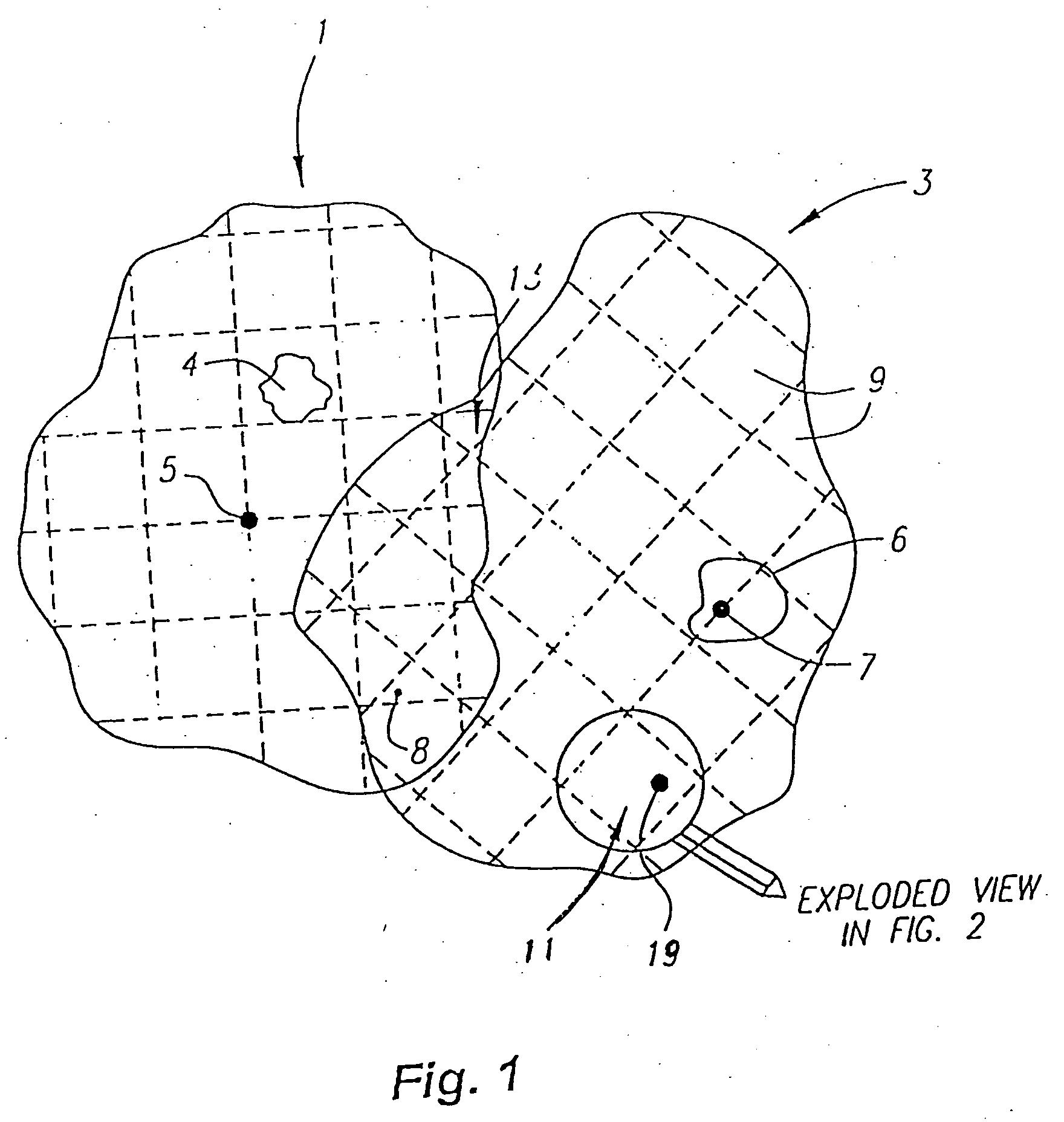
[0076] Hierarchical Identifiers For Country, State / Province, City

[0077] The example assumes the existence of higher levels of hierarchical codes for identifying countries, states / provinces, and cities. The top level codes can be used, implied by context, or specifically ignored by the use of dots (periods) to make it clear how many codes have been omitted. A code of ‘US.CA.LA’ might be represented as ‘LA’, ‘ . . . LA’, or by ‘CA.LA’, depending on the geographic context or the need for clarity.

[0078] In all cases, upper level codes are dropped when the geographic context is clear, to prefix with dots (periods) when necessary to insure clarity, and to append lower levels to add precision.

[0079] Country Codes

[0080] Top level: two alpha character mnemonic (possibly based on Internet domain codes).

[0081] Examples: [0082] United States=US [0083] Australia=AU [0084] Canada=CA

[0085] State / Province Codes

[0086] Second level: two character mnemonics (advantageously based on ...

example 1a

B. EXAMPLE 1A

[0123] In addition to the example above which demonstrates one means for implementing the city grid, this example describes an alternative means for implementing the city grid based on the Transverse Mercator projection system.

[0124] In a preferred implementation a conventional map projection / coordinate system grid is selected. While Lambert Conformal Conic, Stereographic, or local tangent plane system might well be used, in this example, the Transverse Mercator (TM) projection is selected. The TM projection is preferred over other projections suitable for use in local mapping systems because it is most likely an available projection in many GIS and GPS platforms.

[0125] To make city centroid selection less contentious an issue, one preferably uses lists of centroids from the Digital Chart of The World (VMapO) or other sources and moves them to arbitrary points that are defined in controlled lists. In order to remove the slight differences in city centroids from differ...

example 2

C. EXAMPLE 2

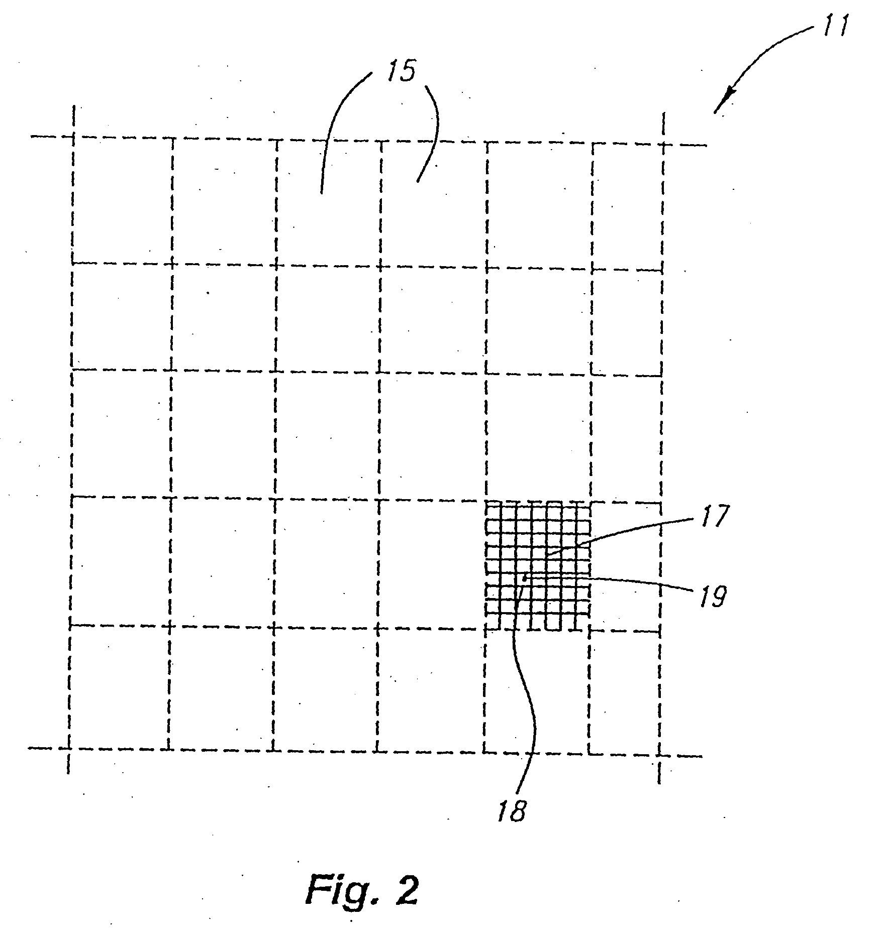
[0148] In addition to the example above which demonstrates the logic and structure of the XYZ.12.34.56.78 format, this example describes the use of a grid format and ULA utilizing the XYZ.12.aa.34.aa format. The Country, State / Province, City and Proprietary Codes remain as described in the previous example, but the optional City Grid is structured differently. The grid code is still initially identified by a pair of numeric characters, and the city grid origin is defined at the ten minute of latitude and ten minute of longitude intersection nearest the city centroid as in the previous example. The definition of each grid and the false easting and northing, as well as the structure of the first grid level, is also as described in the preceding example.

[0149] The next lower level of the grid divides each numeric grid into a twenty by twenty grid (400 grid rectangles) area. East is always first, north is always second. The minimum is A from a character set consisting of AB...


PUM


Abstract

The present invention involves a Universal Geographic Database (“UGD”). The UGD is an automated, central or distributed, registry of real-world locations and location-related information for businesses and other entities, analogous to the registry of domain names for Internet and web sites. By this central registry, businesses and other entities are facilitated to post their location and location-related information in a single place, for all users who need or want it; and users can refer to this single place, via the Internet, Web, and other telecommunications devices, to obtain accurate, complete and timely location and location-based information about the registered businesses and other entities. Each record of the UGD is keyed by a proprietary location address (PLA) based on the World Geographic Referencing System (WGRS), and optionally may have one or more proprietary location addresses (PLAs), which also may serve as keys. Associated with the PLA keys, each UGD record generally includes the full name for the business or other entity, its street address, and miscellaneous contact information (e.g., telephone number, facsimile number, e-mail address, internet website address, wireless website address). Other more dynamic, customized information (e.g., store hours, credit cards accepted, inventory, prices, specials, hours, parking) also may be available in the UGD record or linked to the UGD record. Users of any device or service can access the UGD through one or more location name servers (LNS), which can provide access to the UGD or other location-based information linked to the UGD or LNS. Based on the WGRS, PLAs provide, in addition to unique keys for UGD records, a user-friendly notation for location naming in the real-world and on all types of location-sensitive electronic devices, from web phones to in-car navigation systems. Given the UGD, these ULA/PLAs are as important to real-world businesses as their domain names because these WGRS addresses drive real-world commerce to physical business locations just as domain names drive e-commerce Internet or web sites.

Description

RELATED APPLICATIONS [0001] This application is a continuation-in-part of U.S. patent application Ser. No. 09 / 257,462, filed Feb. 25, 1999, now pending, which is a continuation-in-part of U.S. patent application Ser. No. 09 / 188,153, filed Nov. 4, 1998, now U.S. Pat. No. 6,047,236, which is a continuation of U.S. patent application Ser. No. 08 / 701,586, filed Aug. 22, 1996, now U.S. Pat. No. 5,839,088. The above referenced patents and patent applications are incorporated herein by reference as if set forth in full.BACKGROUND OF THE INVENTION [0002] 1. Field of the Invention [0003] The present invention relates to a Unified Geographic Database (“UGD”), and methods of creating, acquiring, managing, maintaining, using and distributing location-based information through both centralized and distributed databases referred to as a Location Name Servers. The Location Name Servers are accessible through a variety of devices and computer systems, including the Internet, communications networks...

Claims


Application Information

Patent Timeline
Patent Type & Authority Applications(United States)
IPC IPC(8): G01C21/20G01C21/26G06F7/00G06F17/30G09B29/10H04L29/06H04L29/08H04L29/12
CPCG01C21/20H04L69/329G06F17/30241G06F17/3087G06F2216/01G09B29/106H04L29/06H04L29/12009H04L29/12047H04L61/15H04L67/16H04L67/42H04L67/04H04L67/02H04L67/18G01C21/26G06F16/29G06F16/9537H04L61/45H04L61/00H04L67/52H04L67/51G01C21/3878G01C21/3881H04L9/40H04L67/01
Inventor HANCOCK, S. LEEHASTINGS, JORDANMORRISON, SCOTT D.
Owner WGRS LICENSING
Why Eureka
Try Eureka