Use of geo-stationary satellites to augment wide_area multilateration synchronization

a multi-lateration synchronization and satellite technology, applied in direction finders, instruments, measurement devices, etc., can solve problems such as satellite availability, availability and spoofing, and use of gps, so as to improve the accuracy and reliability of wide-area multi-lateration systems, and improve wamlat timing availability

Inactive Publication Date: 2007-01-04
OMNIPOL
View PDF99 Cites 63 Cited by
  • Summary
  • Abstract
  • Description
  • Claims
  • Application Information

AI Technical Summary

Benefits of technology

[0038] The present invention improves WAMLAT Timing Availability by using timing from one or more of a variety of sources. These sources include unaugmented SATNAV timing, from GPS or / and GALILEO, GEO timing from pseudo SATNAV signals, additional GEO timing for non SATNAV applications, timing signals from analog and digital television and radio transmitters, and stable on board oscillators to withstand short term interruptions in satellite timing. The use of one or more of these multiple sources of timing improves the accuracy and reliability of wide area multilateration systems.

Problems solved by technology

While ADS-B promises global accurate tracking of aircraft using a significantly lower-cost surveillance infrastructure than today's conventional radar surveillance, there are issues regarding availability and spoofing.
Satellite availability is another issue affecting the use of GPS in wide-area multilateration.

Method used


Image

  • Use of geo-stationary satellites to augment wide_area multilateration synchronization
  • Use of geo-stationary satellites to augment wide_area multilateration synchronization
  • Use of geo-stationary satellites to augment wide_area multilateration synchronization

Examples


Embodiment Construction

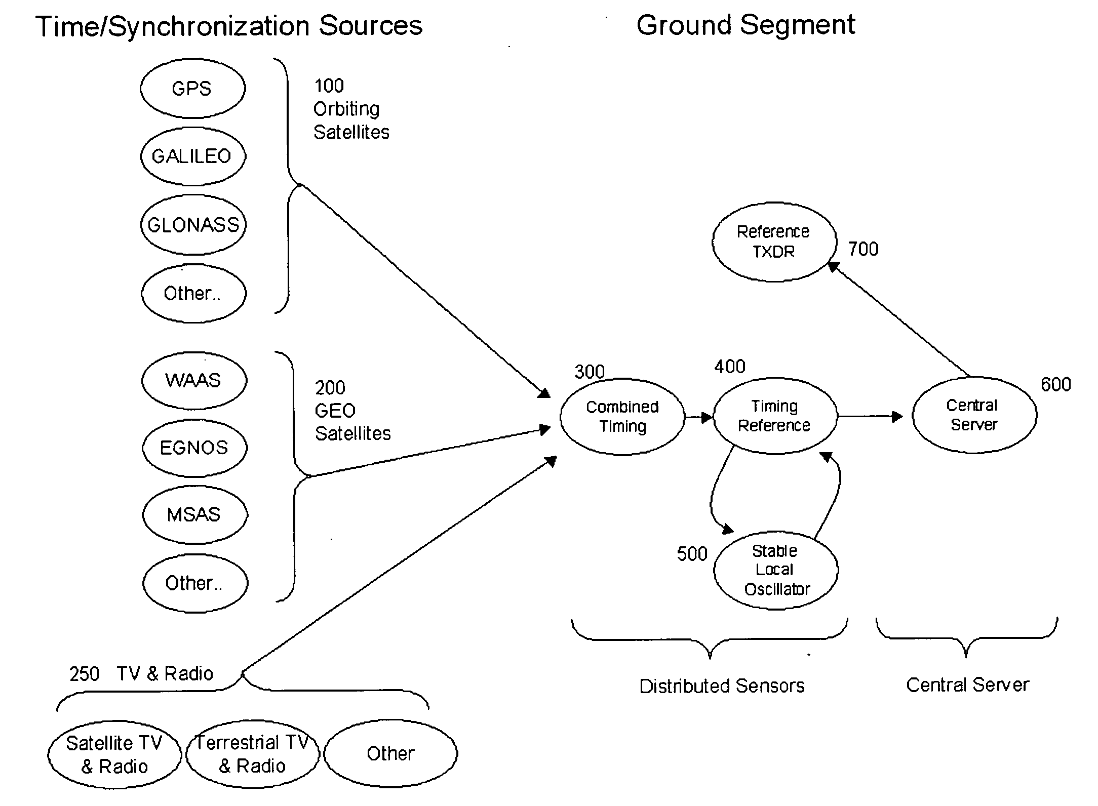
[0049]FIG. 10 is a block diagram illustrating one embodiment of the present invention with a space segment and a ground segment. Orbiting satellites 100 shown to include the U.S. GPS, the European GALILEO, the Russian GLONASS, and other orbiting satellite-based navigation and television and radio broadcast systems. The GEO timing is shown 200 from the U.S. WAAS system, the European EGNOS system, the Japanese MSAS system, and other overlays and GEO services. Similarly, both terrestrial and satellite-based television and radio transmitters 250 shown to include the U.S. ATSC system, European DVB system, and Japanese ISDB as well as the XM, Sirius, Worldspace, and DAB radio systems, will also provide time synchronization information.

[0050] In this embodiment, all the timing sources are combined to give a best estimate of synchronization at sensor 300. Note that it is possible to combine the orbiting and GEO timing information in different ways. For example, depending on preference a pr...


PUM


Abstract

The present invention improves WAMLAT Timing Availability by using timing from one or more of a variety of sources. These sources include unaugmented SATNAV timing, from GPS or / and GALILEO, GEO timing from pseudo SATNAV signals, additional GEO timing for non SATNAV applications, timing derived from both terrestrial and satellite television and radio transmissions, and stable on board oscillators to withstand short term interruptions in satellite timing. The use of one or more of these multiple sources of timing improves accuracy and reliability of wide area multilateration systems.

Description

CROSS-REFRENCE TO RELATED APPLICATIONS [0001] The present application is a Continuation-In-Part application of U.S. patent application Ser. No. 10 / 457,439, filed on Jun. 10, 2003, (RANN-0013) now U.S. Pat. No. 6,885,340 and incorporated herein by reference in its entirety; U.S. patent application Ser. No. 10 / 457,439 in turn is a Continuation-In-Part application of U.S. patent application Ser. No. 09 / 971,672, filed on Oct. 9, 2001, (RANN-0009) entitled “METHOD AND APPARATUS FOR IMPROVING THE UTILITY OF AUTOMATIC DEPENDENT SURVEILLANCE”, now U.S. Pat. No. 6,567,043 which in turn is a Divisional Application of Ser. No. 09 / 516,215, filed Mar. 5, 1999, (RANN-0005) entitled “METHOD AND APPARATUS FOR IMPROVING THE UTILITY OF AUTOMATIC DEPENDENT SURVEILLANCE”, now U.S. Pat. No. 6,633,259, all of which are incorporated herein by reference in their entirety; U.S. patent application Ser. No. 10 / 457,439 is also a Continuation-In-Part of U.S. patent application Ser. No. 10 / 319,725, filed Dec. 16...

Claims


Application Information

Patent Timeline
Patent Type & Authority Applications(United States)
IPC IPC(8): G01S1/24G01S3/02
CPCG01S5/0221G01S5/06G01S19/48G01S19/15G01S19/33G01S19/07G01S19/072G01S5/02216
Inventor SMITH, ALEXANDER E.BREEN, THOMAS J.
Owner OMNIPOL
Why Eureka
Try Eureka