System and method for detecting false navigation signals

a false navigation and signal detection technology, applied in the field of navigation, can solve the problems of generating an inaccurate estimate of position, velocity and time, subject to spoofing, etc., and achieve the effect of high degree of confiden

Active Publication Date: 2007-08-23
HONEYWELL INT INC
View PDF13 Cites 47 Cited by
  • Summary
  • Abstract
  • Description
  • Claims
  • Application Information

AI Technical Summary

Benefits of technology

[0004] The present invention provides a system and method for detecting and excluding false GPS signals, by predicting a GPS measurement value with a high degree of confidence, comparing the predicted value with measured values, and rejecting a false measurement based on the comparison results. In accordance with a preferred embodiment of the present invention, a tightly coupled GPS / Inertial Navigation System (GPS / INS) is provided, which uses a Kalman filter for comparison of a predicted GPS measurement value with measured values (e.g., the residuals) to form the basis for the rejection of false measurements. This rejection is referred to as a chi-squared reject, and can be extended in time in order to apply the same test to a reacquired signal following the loss of an original GPS signal. The Kalman filter propagates the receiver's clock bias rate, and enables the system to predict the GPS measurements at the time of reacquisition. The residuals are compared to a limit defined by the uncertainties of the prediction and the measurement errors expected to be involved.

Problems solved by technology

A significant problem with existing GPS receivers is that they are subject to jamming and spoofing.
This indirect, deceptive GPS signal is received by a GPS receiver, which produces an inaccurate estimate of position, velocity and time, as a result.

Method used


Image

  • System and method for detecting false navigation signals
  • System and method for detecting false navigation signals
  • System and method for detecting false navigation signals

Examples


Embodiment Construction

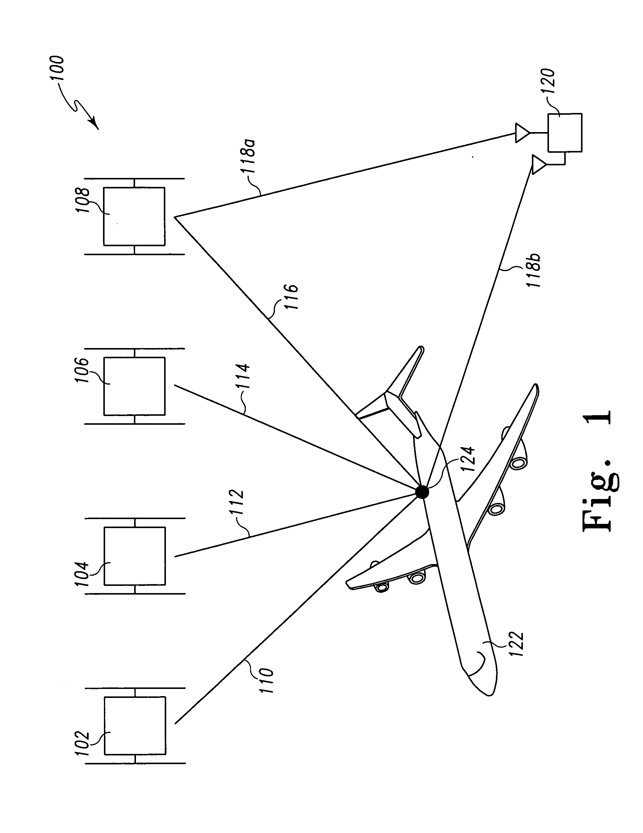
[0009] With reference now to the figures, FIG. 1 depicts a pictorial representation of an example system 100 for detecting false satellite navigation signals, in accordance with a preferred embodiment of the present invention. Notably, the satellite navigation system signals described for this example embodiment are GPS signals, but the present invention is not intended to be so limited and can include within its scope signals from other types of radio-navigation systems (e.g., GBAS, GNSS, etc.). For this example embodiment, system 100 includes a plurality of radio-navigation satellites 102, 104, 106, 108. For clarity, only four satellites are shown, but it should be understood that existing and future satellite navigation systems can include more than four satellites visible at any time. Each satellite 102, 104, 106, 108 includes a transmitter, which transmits a respective navigation signal 110, 112, 114, 116. System 100 also includes a satellite navigation receiver 124, which rece...


PUM


Abstract

A system and method for detecting and excluding false GPS signals are disclosed, which predict a GPS measurement value with a high degree of confidence, compare the predicted value with measured values, and reject a false measurement based on the comparison results. As one example, a tightly coupled GPS / Inertial Navigation System (GPS / INS) is disclosed, which uses a Kalman filter for comparison of a predicted GPS measurement value with measured values (e.g., the residuals) to form the basis for the rejection of false measurements. This rejection is referred to as a chi-squared reject, and can be extended in time in order to apply the same test to a reacquired signal following the loss of an original validated GPS signal. The Kalman filter propagates the receiver's clock bias rate, and enables the system to predict the GPS measurements at the time of reacquisition. The residuals are compared to a limit defined by the uncertainties of the prediction and the measurement errors expected to be involved.

Description

FIELD OF THE INVENTION [0001] The present invention relates generally to the navigation field, and more specifically, but not exclusively, to a system and method for detecting false navigation signals such as, for example, false Global Positioning System (GPS) signals. BACKGROUND OF THE INVENTION [0002] The GPS is a constellation of 24 earth-orbiting radio-navigation satellites whose orbits are arranged so that at least four of the satellites are visible anywhere on the Earth at any time. A GPS receiver receives signals from four or more of these satellites, and uses trilateration techniques to determine the precise position (e.g., altitude, and latitudinal and longitudinal coordinates) of the receiver on or near the Earth. Also, using the received signals, a GPS receiver computes velocity and time. Thus, GPS receivers are used to provide precise position, velocity and time information for users that include, but are not limited to, aircraft, missiles, ships, ground-based vehicles, ...

Claims


Application Information

Patent Timeline
Patent Type & Authority Applications(United States)
IPC IPC(8): G01S5/14G01S19/21G01S19/29G01S19/30
CPCG01S19/21G01S19/215
Inventor WAID, JAMES D.
Owner HONEYWELL INT INC
Why Eureka
Try Eureka